 PDF(2513 KB)

成都市鸟类多样性时空分布格局及热点区域识别
任诗超, 张银龙, 曹铭昌, 刘威, 乔姝凡, 朱晓泾, 罗康宁
南京林业大学学报(自然科学版) ›› 2024, Vol. 48 ›› Issue (5) : 189-196.
PDF(2513 KB)
 PDF(2513 KB)
成都市鸟类多样性时空分布格局及热点区域识别
The bird diversity spatial and temporal distribution patterns and its hotspot areas identification in Chengdu City
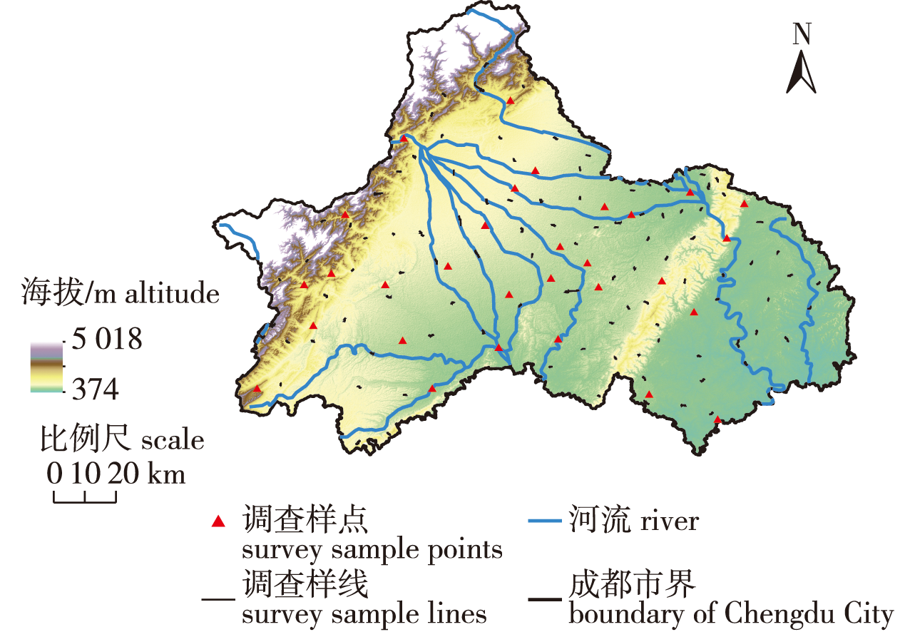
【目的】探究成都市鸟类群落结构及空间分布格局特征,分析不同生境和季节的鸟类组成差异,识别鸟类热点区域,为成都市及相似区域的鸟类多样性保护提供依据。【方法】2020年,采用样线法和样点法对成都市20个行政区开展不同季节的鸟类多样性调查,通过计算物种丰富度、Shannon-Wiener多样性指数、Simpson指数、Pielou均匀度指数以及群落相似性系数对成都市鸟类进行多样性分析,选取41种重点鸟类并按照生态习性将其分为猛禽、陆禽、游禽、涉禽4类,应用MaxEnt模型进行成都市重点鸟类潜在生境预测,识别成都市鸟类多样性热点区域。【结果】共调查到鸟类17目62科261种,包括国家一级重点保护鸟类1种,国家二级重点保护鸟类29种。其中留鸟99种,夏候鸟61种,冬候鸟60种,旅鸟41种。在不同季节间鸟类物种数和个体数、Shannon-Wiener多样性指数、Simpson指数和Pielou均匀度指数皆表现为冬季>春季>秋季>夏季。6种生境中,森林(200种)和湿地(169种)鸟类物种数较多,城镇用地和湿地的鸟类个体数和种群规模较大,森林生境中鸟类Shannon-Wiener多样性指数、Simpson指数最高,城镇用地中鸟类均匀度指数最高。MaxEnt模型预测结果显示,猛禽分布受土地覆被类型、距湖泊距离、距森林距离影响较大,陆禽分布受距森林距离、海拔、居民点密度影响较大,游禽、涉禽等水鸟分布则受土地覆被类型、距湖泊距离等影响较大。成都市鸟类多样性热点区域主要分布在自然保护区、西部龙门山脉,西南部朝阳湖,东部龙泉山森林公园,南部三岔湖、兴隆湖、青龙湖湿地公园及岷江、沱江河流等区域。【结论】成都市丰富的鸟类多样性与其自然环境密切相关,其中森林面积较大、空间异质性高且食物来源丰富,是鸟类重要的栖息地;湿地面积虽占比较小(仅约占全市总面积的2%),但鸟类丰富度仅次于森林,在今后鸟类生物多样性保护中同样应重点关注。
【Objective】This study aims to explore the structural composition and spatial distribution patterns of bird communities in Chengdu, Sichuan, China, analyze the differences in bird diversity across various habitats and seasons, and identify bird hotspots to provide a basis for bird diversity protection in Chengdu and similar areas.【Method】In 2020, a survey of bird diversity was conducted across different seasons in 20 administrative districts of Chengdu using the line transect method and the sampling point methods. Species richness, Shannon-Wiener diversity index, Simpson index, Pielou evenness index, and community similarity coefficient were calculated to analyze bird diversity in Chengdu. Additionally, 41 key bird species were selected and categorized into raptorial birds, terrestrial birds, natatorial birds, and wading birds based on their ecological habits. The MaxEnt model was used to predict the potential habitats of key birds and identify bird biodiversity hotspots in Chengdu.【Result】A total of 261 bird species across 17 Orders and 62 Families were identified, including one species under national first-class key protection and 29 species under national second-class key protection. Among these, there are 99 species of resident birds, 61 species of summer migratory birds, 60 species of winter migratory birds, and 41 species of transient birds. The number of bird species and individuals, the Shannon-Wiener diversity index, the Simpson index, and the Pielou evenness index were highest in winter, followed by spring, autumn, and summer. Among the six habitats studied, forests (200 species) and wetlands (169 species) had the highest bird species counts. Urban land and wetlands had the highest number of individual birds and population sizes. Forest habitats exhibited the highest Shannon-Wiener diversity index and Simpson index, while urban land had the highest evenness index. The MaxEnt model predictions showed that the distribution of raptorial birds was significantly influenced by land cover type, distance from lakes, and distance from forests. Terrestrial birds distribution was largely affected by distance from forests, altitude, and settlement density. The distribution of waterbirds, including natatorial birds and wading birds, was heavily influenced by land cover type and distance from lakes. Chengdu’s bird diversity hotspots are primarily located in nature reserves, the Longmen Mountain Range, Chaoyang Lake, Longquan Mountain Forest Park, Sancha Lake, Xinglong Lake, Qinglonghu Wetland Park, and along the Minjiang and Tuojiang Rivers.【Conclusion】The rich bird diversity in Chengdu is closely linked to its natural environment, characterized by extensive forest areas, high spatial heterogeneity, and abundant food sources, making it a crucial habitat for birds. Although wetlands comprise only about 2% of the city’s land area, they rank second to forests in bird richness and should be a focal point in future bird biodiversity conservation efforts.
鸟类多样性 / 群落结构 / 空间分布 / MaxEnt模型 / 潜在生境分布 / 热点区域 / 成都市
bird diversity / community structure / spatial distribution / MaxEnt model / potential habitat distribution / hotspot areas / Chengdu City
| [1] |
|
| [2] |
李俊冬, 査禄慧, 马国强, 等. 云南楚雄小百草岭鸟类多样性空间格局[J]. 南京林业大学学报(自然科学版), 2023, 47(2):225-233.
|
| [3] |
张健嵩, 陆文朱, 汤锦涛, 等. 云南省永德县繁殖季鸟类多样性[J]. 生态与农村环境学报, 2021, 37(11):1423-1429.
|
| [4] |
孙孝平, 张银龙, 曹铭昌, 等. 黄河三角洲自然保护区秋冬季水鸟群落组成与生境关系分析[J]. 生态与农村环境学报, 2015, 31(4):514-521.
|
| [5] |
邵君学, 胡昕欣, 王俪玢, 等. 湿地公园鸟类栖息地禾本科群落盖度对雀形目鸟类集团的影响[J]. 南京林业大学学报(自然科学版), 2022, 46(4):194-200.
|
| [6] |
王茜, 刘智存, 刘天宇, 等. 城市鸟类多样性研究中的多维度探索研究进展[J]. 生态学杂志, 2022, 41(10):2058-2063.
|
| [7] |
杨永炳, 普布, 杨乐. 西藏东南横断山区鸟类多样性概述[J]. 西部林业科学, 2021, 50(6):149-158,165.
|
| [8] |
王恩平, 陈爽. 成都市区麻雀夜宿规律初步观察[J]. 四川动物, 2004, 23(4):352-354.
|
| [9] |
唐林芳, 贾陈喜. 四川都江堰东方草鸮的繁殖记录[J]. 动物学杂志, 2015, 50(2):251,321.
|
| [10] |
姜明敏, 曹林, 肖治术, 等. 都江堰林区取食樱桃果实(种子)的鸟类及其种子扩散作用[J]. 动物学杂志, 2010, 45(1):27-34.
|
| [11] |
廖婷, 廖静, 冉江洪, 等. 四川彭州市的鸟类多样性[J]. 四川动物, 2021, 40(1):99-114.
|
| [12] |
张尚明玉, 何兴成, 王燕, 等. 都江堰地区繁殖期鸟类多样性[J]. 生物多样性, 2022, 30(3):90-98.
|
| [13] |
李云, 韦毅, 董鑫, 等. 四川省湿地水鸟资源现状与保护[J]. 生态学杂志, 2020, 39(6):1847-1857.
|
| [14] |
罗艳, 杨一川, 沈松平, 等. 城市化对成都市植被景观格局影响研究[J]. 四川林业科技, 2021, 42(5):29-39.
|
| [15] |
|
| [16] |
约翰·马敬能, 卡伦·菲力普斯. 中国鸟类野外手册[M].卢何芬,译. 长沙: 湖南教育出版社, 2000.
|
| [17] |
郑光美. 中国鸟类分类与分布名录[M]. 3版. 北京: 科学出版社, 2017.
|
| [18] |
张荣祖. 中国动物地理[M]. 北京: 科学出版社, 2011.
|
| [19] |
马克平, 刘玉明. 生物群落多样性的测度方法 Ⅰ.α多样性的测度方法(下)[J]. 生物多样性, 1994, 2(4):231-239.
|
| [20] |
邢丁亮, 郝占庆. 最大熵原理及其在生态学研究中的应用[J]. 生物多样性, 2011, 19(3):295-302.
|
| [21] |
赵宁, 夏少霞, 于秀波, 等. 基于MaxEnt模型的渤海湾沿岸鸻鹬类栖息地适宜性评价[J]. 生态学杂志, 2020, 39(1):194-205.
|
| [22] |
张琼悦, 邓卓迪, 胡学斌, 等. 粤港澳大湾区城市化进程对区域内鸟类分布及栖息地连通性的影响[J]. 生物多样性, 2023, 31(3):72-84.
|
| [23] |
吕环鑫, 夏少霞, 顾婧婧, 等. 基于MaxEnt模型的仙居县大型兽类和珍稀鸟类栖息地适宜性评价[J]. 生态学杂志, 2023, 42(11):2797-2805.
|
| [24] |
|
| [25] |
罗绮琪, 胡慧建, 徐正春, 等. 基于Maxent模型的粤港澳大湾区水鸟多样性热点研究[J]. 生态学报, 2021, 41(19):7589-7598.
|
| [26] |
环境保护部, 中国科学院. 中国生物多样性红色名录——脊椎动物卷(2020)[EB/OL].[2023-05-19]. https://www.mee.gov.cn/xxgk2018/xxgk/xxgk01/202305/t20230522-1030745.html.
|
| [27] |
阙品甲, 朱磊, 张俊, 等. 四川省鸟类名录的修订与更新[J]. 四川动物, 2020, 39(3):332-360.
|
| [28] |
尹世轩, 吴永波, 黄潇宇. 常州市金坛生态红线区鸟类多样性研究[J]. 南京林业大学学报(自然科学版), 2023, 47(4):219-225.
|
| [29] |
王玄, 崔鹏, 丁晶晶, 等. 江苏南部沿海越冬水鸟群落结构及多样性分析[J]. 南京林业大学学报(自然科学版), 2021, 45(5):178-184.
|
| [30] |
汪婷, 周立志. 合肥市小微湿地鸟类多样性的时空格局及其影响因素[J]. 生物多样性, 2022, 30(7):146-158.
|
/
| 〈 |
|
〉 |


