 PDF(3897 KB)
 PDF(3897 KB)
 PDF(3897 KB)
基于空间光谱信息协同的城市不透水层提取方法比较研究
Comparing four methods for extracting impervious surfaces using spectral information in synergy with spatial heterogeneity of remotely sensed imagery

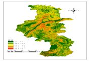
【目的】利用不同的端元提取方法及混合像元分解算法计算南京市2018年城市不透水层覆盖度,评估各方法的精度,为城市可持续发展提供可靠的基础数据支撑。【方法】采用Landsat 8 OLI遥感影像,基于像元纯度指数(pixel purity index,PPI)并考虑空间光谱信息协同提出空间像元纯度指数(spatial pixel purity index,SPPI),精炼提纯植被、裸土、高反照度不透水层及低反照度不透水层4种类型端元,利用线性混合光谱模型(linear mixed spectral model,LMM)、混合调制匹配滤波(mixture tuned matched filtering,MTMF)、双线性混合光谱模型(bilinear mixed spectral model,BMM)及BP神经网络(BP neural network,BPNN)算法提取南京城市不透水层,采用同年的Google Earth遥感影像目视解译结果对提取的不透水层丰度进行精度验证。【结果】SPPI能有效结合多光谱波段的光谱信息和全色波段的空间信息,提高端元提取精度并减少计算量;同时,基于SPPI的BP神经网络算法提取精度最高,为90.45%;而基于PPI的线性混合光谱模型精度最低,为80.62%。BP神经网络算法在复杂城市中的解混精度高于线性混合光谱模型、混合调制匹配滤波和双线性混合光谱模型。【结论】采用全色波段像元亮度空间异质性辅助提取端元的方法,用空间信息弥补多光谱波段光谱信息较少的缺点,对于改进或发展适用于中/高分辨率多光谱影像的端元提取方法具有一定的参考价值,将其与神经网络模型结合可以在城市不透水层提取中推广应用。
【Objective】 In order to provide a reliable foundation for the sustainable development of Nanjing City, this study compared different endmember extraction methods and mixed pixel decomposition algorithms to calculate the coverage of urban impervious surfaces (UISs) in Nanjing in 2018, and evaluated the accuracy of each method. 【Method】 Using Landsat 8 OLI images, an improved spatial pixel purity index (SPPI), based on the pixel purity index (PPI), was first proposed to refine or purify the endmembers for four land cover types including vegetation, bare soil, high albedo UISs and low albedo UISs. Next, based on the two extracted suites of endmembers derived from PPI and SPPI, a linear spectral mixed model, a mixture tuned matched filtering, a bilinear mixed spectral model and a BP neural network were implemented to extract UISs in Nanjing. The extracted UIS abundance was validated using visual interpretation of high spatial resolution Google Earth images for 2018. 【Result】 The results showed that SPPI could improve the identification accuracy of endmembers effectively and reduce the computational load by combining the spectral information from multi-spectral bands with the spatial heterogeneity of the panchromatic band. The UIS extraction accuracy of the SPPI-based BP network algorithm was the highest, at 90.45%, while the PPI-based linear spectral mixed model was the lowest at 80.62%. Overall, the BP network model outperformed the other three models in UIS extraction, regardless of whether PPI-based or SPPI-based endmembers were used. 【Conclusion】 The proposed method of using the panchromatic band to assist with extracting endmembers effectively integrated spatial heterogeneity to compensate for inadequate spectral information in the multispectral bands. The study provides methodological references to improve or develop means for endmember extraction from medium/high-resolution multispectral images. Additionally, integration of the SPPI and BP network model can be popularized in the UIS extraction domain.
城市不透水层 / 空间像元纯度指数 / 混合调制匹配滤波 / 双线性混合光谱模型 / BP神经网络 / 线性混合光谱模型
urban impervious surface / spatial pixel purity index(SPPI) / mixture tuned matched filtering(MTMF) / bilinear mixed spectral model(BMM) / BP neural network(BPNN) / linear mixing spectral model(LMM)
| [1] |
|
| [2] |
|
| [3] |
仵宏基. 基于长时间序列陆地卫星数据的南京城市不透水层动态制图研究[D]. 南京:南京林业大学, 2017.
|
| [4] |
|
| [5] |
吴志杰, 赵书河. 基于TM图像的“增强的指数型建筑用地指数”研究[J]. 国土资源遥感, 2012,24(2):50-55.
以Landsat TM/ETM+图像为数据源,研究城镇和农村建筑用地信息的提取方法。首先利用TM 7,4,2波段创建归一化差值裸地与建筑用地指数(normalized difference bareness and built-up index, NDBBI ); 然后根据裸地在裸土指数(bare doil index, BSI)图像上的亮度值最高、在改进型归一化差值水体指数(modified normalized difference water index, MNDWI)图像的亮度值最低的特征,提出了增强型裸土指数(enhanced bare soil index, EBSI); 最后选用NDBBI,EBSI,MNDWI和SAVI(soil adjustment vegetation index, SAVI)4个指数,构建一种新型的建筑用地指数,称为"增强的指数型建筑用地指数"(enhanced index-based built-up index,EIBI),可快速地提取建筑用地信息。实验结果表明,用EIBI提取的建筑用地信息客观,人为干预少,可信度高,提取精度可达90%以上,适合于同时提取城市和农村建筑用地信息。
|
| [6] |
|
| [7] |
甘玉泉. 高光谱遥感图像光谱解混方法研究及其应用[D]. 北京:中国科学院大学, 2018.
|
| [8] |
蓝金辉, 邹金霖, 郝彦爽, 等. 高光谱遥感影像混合像元分解研究进展[J]. 遥感学报, 2018,22(1):13-27.
|
| [9] |
|
| [10] |
|
| [11] |
杨斌, 王斌. 高光谱遥感图像非线性解混研究综述[J]. 红外与毫米波学报, 2017,36(2):173-185.
|
| [12] |
Is perception of the whole based on perception of its parts? There is psychological and physiological evidence for parts-based representations in the brain, and certain computational theories of object recognition rely on such representations. But little is known about how brains or computers might learn the parts of objects. Here we demonstrate an algorithm for non-negative matrix factorization that is able to learn parts of faces and semantic features of text. This is in contrast to other methods, such as principal components analysis and vector quantization, that learn holistic, not parts-based, representations. Non-negative matrix factorization is distinguished from the other methods by its use of non-negativity constraints. These constraints lead to a parts-based representation because they allow only additive, not subtractive, combinations. When non-negative matrix factorization is implemented as a neural network, parts-based representations emerge by virtue of two properties: the firing rates of neurons are never negative and synaptic strengths do not change sign.
|
| [13] |
|
| [14] |
This paper presents a nonlinear mixing model for hyperspectral image unmixing. The proposed model assumes that the pixel reflectances are nonlinear functions of pure spectral components contaminated by an additive white Gaussian noise. These nonlinear functions are approximated using polynomial functions leading to a polynomial postnonlinear mixing model. A Bayesian algorithm and optimization methods are proposed to estimate the parameters involved in the model. The performance of the unmixing strategies is evaluated by simulations conducted on synthetic and real data.
|
| [15] |
|
| [16] |
夏俊士, 杜培军, 曹文. 基于非线性光谱混合模型的遥感影像提取城市不透水层[J]. 光子学报, 2011,40(1):13-18.
针对传统方法在提取城市不透水层中的许多局限性,采用两种非线性光谱混合分解模型,包括混合调谐匹配滤波和多层感知器神经网络,通过混合像元分解获取城市不透水层.混合调谐匹配滤波利用用户选择的端元,通过最大化端元响应并减少未知背景信息的影响,进行局部分解端元.多层感知器由多个感知器组成,能够很好的进行非线性学习.对Landsat TM遥感影像进行最大噪声分离,使其转换到另外一个特征空间.利用新生成数据集的前三个成分(占90%以上信息量)进行纯净像元提取,并利用N维可视化分析器寻找出四个进行分解的端元:植被、高反射率地物、低反射率地物和土壤.不透水层则由高反射率和低反射率两个分量估算而成.对不同模型提取的结果,利用QuickBird多光谱图像评价其准确性.实验结果表明人工神经网络的精度最高,即非线性光谱混合模型同样可以有效地提取不透水层,精度甚至优于线性模型.
|
| [17] |
|
| [18] |
|
| [19] |
|
| [20] |
|
| [21] |
焦俊男. 基于空间光谱信息协同的多光谱影像端元精确提取方法研究[D]. 南京:南京大学, 2017.
|
| [22] |
南京市规划和自然局. 2018年季度国土资源综合统计报告[R/OL].(2019-04-28)[2019-10-29] http://zrzy.jiangsu.gov.cn/gtapp/nrglIndex.action?type=2&messageID=2c9082b56a2e4062016a62ac17c40a60.html.
|
| [23] |
The surface reflectance, i.e., satellite derived top of atmosphere (TOA) reflectance corrected for the temporally, spatially and spectrally varying scattering and absorbing effects of atmospheric gases and aerosols, is needed to monitor the land surface reliably. For this reason, the surface reflectance, and not TOA reflectance, is used to generate the greater majority of global land products, for example, from the Moderate Resolution Imaging Spectroradiometer (MODIS) and Visible Infrared Imaging Radiometer Suite (VIIRS) sensors. Even if atmospheric effects are minimized by sensor design, atmospheric effects are still challenging to correct. In particular, the strong impact of aerosols in the Visible and Near Infrared spectral range can be difficult to correct, because they can be highly discrete in space and time (e.g., smoke plumes) and because of the complex scattering and absorbing properties of aerosols that vary spectrally and with aerosol size, shape, chemistry and density. This paper presents the Landsat 8 Operational Land Imager (OLI) atmospheric correction algorithm that has been developed using the Second Simulation of the Satellite Signal in the Solar Spectrum Vectorial (6SV) model, refined to take advantage of the narrow OLI spectral bands (compared to Thematic Mapper/Enhanced Thematic Mapper (TM/ETM+)), improved radiometric resolution and signal-to-noise. In addition, the algorithm uses the new OLI Coastal aerosol band (0.433-0.450mum), which is particularly helpful for retrieving aerosol properties, as it covers shorter wavelengths than the conventional Landsat, TM and ETM+ blue bands. A cloud and cloud shadow mask has also been developed using the
|
| [24] |
徐涵秋. 利用改进的归一化差异水体指数(MNDWI)提取水体信息的研究[J]. 遥感学报, 2005,9(5):589-595.
在对M cfeeters提出的归一化差异水体指数(NDWI)分析的基础上,对构成该指数的波长组合进行了修改,提出了改进的归一化差异水体指数MNDWI(M odified NDWI),并分别将该指数在含不同水体类型的遥感影像进行了实验,大部分获得了比NDWI好的效果,特别是提取城镇范围内的水体。NDWI指数影像因往往混有城镇建筑用地信息而使得提取的水体范围和面积有所扩大。实验还发现MNDWI比NDWI更能够揭示水体微细特征,如悬浮沉积物的分布、水质的变化。另外,MNDWI可以很容易地区分阴影和水体,解决了水体提取中难于消除阴影的难题。
|
| [25] |
苏红军, 刘浩. 一种利用空间和光谱信息的高光谱遥感多分类器动态集成算法[J]. 国土资源遥感, 2017,29(2):15-21.
|
| [26] |
王靖, 吴见. 融入空间信息的湿地信息提取技术[J]. 南京林业大学学报(自然科学版), 2014,38(4):19-22.
|
| [27] |
杨斌, 王斌, 吴宗敏. 基于双线性混合模型的高光谱图像非线性光谱解混[J]. 红外与毫米波学报, 2018,37(5):631-641.
|
/
| 〈 |
|
〉 |


