基于生态环境质量评价的酒泉市生态空间网络优化

仇实, 于强, 刘泓君, 王慧媛, 李松, 岳德鹏

南京林业大学学报(自然科学版) ›› 2024, Vol. 48 ›› Issue (2) : 199-208.

PDF(3686 KB)
PDF(3686 KB)
南京林业大学学报(自然科学版) ›› 2024, Vol. 48 ›› Issue (2) : 199-208. DOI: 10.12302/j.issn.1000-2006.202204070
研究论文

基于生态环境质量评价的酒泉市生态空间网络优化

作者信息 +

The optimization of ecological spatial network in Jiuquan City based on the evaluation of ecological environment quality

Author information +
文章历史 +

摘要

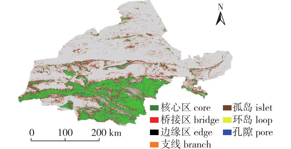
【目的】 构建并优化酒泉地区生态空间网络,提升生态环境质量,发挥区域生态作用,防止沙漠扩张。【方法】 将遥感生态指数(RSEI)与生态空间网络结合,评估酒泉地区景观格局空间,基于复杂网络理论确定薄弱生态源地,提出优化策略。【结果】 ①酒泉市RSEI呈现北部地区低,中南部地区高的空间格局。②酒泉市潜在生态空间网络由332个生态节点,656条生态廊道组成,依照RSEI最低的区域进行增边优化,模拟增边242条,增加生态踏脚石9个。③增边优化后,网络的节点鲁棒性和连接鲁棒性有明显的提升,网络边的鲁棒性略有提升但不明显。【结论】 对生态环境质量弱节点采取增边以及增加踏脚石的优化策略,可使酒泉市生态空间网络的稳定性和生态恢复能力得到一定程度的提升。针对新增生态廊道开展建设,增强源地间的连接,有利于发挥区域生态效益,为酒泉市未来生态工程建设提供策略。

Abstract

【Objective】 The objective of this study is to construct and optimize the ecological spatial network in Jiuquan City, aiming to enhance the quality of the ecological environment, harness regional ecological functions, and prevent desert expansion. 【Method】 By integrating remote sensing ecological index (RSEI) with the ecological spatial network, this study assessed the spatial pattern of landscape in Jiuquan City. By using complex network theory, the study identified weak ecological source areas and proposed optimization strategies. 【Result】 (1) The RSEI exhibited a spatial pattern in the Jiuquan City, with low values in the northern region and high values in the central and southern regions. (2) The potential ecological spatial network in Jiuquan City comprised 332 ecological nodes and 656 ecological corridors. Through the simulation of additional edges based on the region with the lowest RSEI, 242 edges were added, resulting in the inclusion of nine ecological stepping stones. (3) After the addition of edges, there was a noticeable improvement in the robustness of network nodes and connections, while the improvement in edge robustness was slight and not significant. 【Conclusion】 The optimization strategies of adding edges and stepping stones to weak ecological areas can enhance the stability and ecological restoration capacity of the ecological spatial network in Jiuquan City. The construction of new ecological corridors to enhance connectivity between source areas would facilitate regional ecological benefits and provide strategies for future ecological engineering projects in Jiuquan City.

关键词

遥感生态指数(RSEI) / 生态质量评价 / 生态空间网络 / 增边优化 / 鲁棒性

Key words

remote sensing ecological index(RSEI) / ecological quality evaluation / ecological spatial network / edge-increasing optimization / robustness

引用本文

导出引用
仇实, 于强, 刘泓君, . 基于生态环境质量评价的酒泉市生态空间网络优化[J]. 南京林业大学学报(自然科学版). 2024, 48(2): 199-208 https://doi.org/10.12302/j.issn.1000-2006.202204070
QIU Shi, YU Qiang, LIU Hongjun, et al. The optimization of ecological spatial network in Jiuquan City based on the evaluation of ecological environment quality[J]. JOURNAL OF NANJING FORESTRY UNIVERSITY. 2024, 48(2): 199-208 https://doi.org/10.12302/j.issn.1000-2006.202204070
中图分类号: X171.4;P931.1   

参考文献

[1]
徐涵秋. 城市遥感生态指数的创建及其应用[J]. 生态学报, 2013, 33(24):7853-7862.
XU H Q. A remote sensing urban ecological index and its application[J]. Acta Ecol Sin, 2013, 33(24):7853-7862.DOI: 10.5846/stxb201208301223.
[2]
孙桂凯, 王国帅, 魏义熊, 等. 基于改进遥感生态指数的岩溶山区生态质量评价:以澄碧河流域为例[J]. 水土保持通报, 2021, 41(2):230-239,F0003.
SUN G K, WANG G S, WEI Y X, et al. Improvement of remote sensing ecological index in Karst mountainous areas:taking Chengbi River basin as an example[J]. Bull Soil Water Conserv, 2021, 41(2):230-239,F0003.DOI: 10.13624/j.cnki.issn.1001-7445.2020.0248.
[3]
王小宇. 基于遥感生态指数的石漠化地区生态环境质量评价:以贵州花江示范区为例[D]. 贵阳: 贵州师范大学, 2019.
WANG X Y. Evaluation of eco-environmental quality in rocky desertification area based on remote sensing ecological index:a case study of Huajiang Demonstration Zone in Guizhou Province[D]. Guiyang: Guizhou Normal University, 2019.
[4]
彭燕, 何国金, 张兆明, 等. 赣南稀土矿开发区生态环境遥感动态监测与评估[J]. 生态学报, 2016, 36(6):1676-1685.
PENG Y, HE G J, ZHANG Z M, et al. Eco-environmental dynamic monitoring and assessment of rare earth mining area in southern Ganzhou using remote sensing[J]. Acta Ecol Sin, 2016, 36(6):1676-1685.
[5]
于强, 张启斌, 牛腾, 等. 绿色生态空间网络研究进展[J]. 农业机械学报, 2021, 52(12):1-15.
YU Q, ZHANG Q B, NIU T, et al. Research progress and prospect of green ecological space network[J]. Trans Chin Soc Agric Mach, 2021, 52(12):1-15.DOI: 10.6041/j.issn.1000-1298.2021.12.001.
[6]
于强, 岳德鹏, 张启斌, 等. 磴口县景观格局演变特征及生态网络构建[J]. 中国沙漠, 2017, 37(3):601-609.
YU Q, YUE D P, ZHANG Q B, et al. The evolution of landscape pattern and the construction of ecological infrastructure network in Dengkou,Inner Mongolia,China[J]. J Desert Res, 2017, 37(3):601-609.
[7]
马仲武, 王新源, 王小军, 等. 甘肃省酒泉市土地沙漠化现状及动态分析[J]. 中国农业资源与区划, 2018, 39(3):141-147.
MA Z W, WANG X Y, WANG X J, et al. Present situation and dynamic analysis of land desertification in Jiuquan City,Gansu Province[J]. Chin J Agric Resour Reg Plan, 2018, 39(3):141-147.DOI: 10.7621/cjarrp.1005-9121.20180320.
[8]
刘凌冰, 李世平. 西北荒漠化地区土地生态安全评价:以酒泉市为例[J]. 水土保持研究, 2014, 21(4):190-194,202.
LIU L B, LI S P. Evaluation on land ecological security in desertification areas of northwest China:a case study of Jiuquan city[J]. Res Soil Water Conserv, 2014, 21(4):190-194,202.DOI: 10.3969/j.issn.1001-8158.2011.05.008.
[9]
牛腾, 岳德鹏, 张启斌, 等. 潜在生态网络空间结构与特性研究[J]. 农业机械学报, 2019, 50(8):166-175.
NIU T, YUE D P, ZHANG Q B, et al. Spatial structure and characteristics of potential ecological networks[J]. Trans Chin Soc Agric Mach, 2019, 50(8):166-175.DOI: 10.6041/j.issn.1000-1298.2019.08.019.
[10]
王戈, 于强, YANG D, 等. 基于复杂网络分析法的层级生态网络结构研究[J]. 农业机械学报, 2019, 50(7):258-266,312.
WANG G, YU Q, YANG D, et al. Hierarchical ecological network structure based on complex network analysis[J]. Trans Chin Soc Agric Mach, 2019, 50(7):258-266,312.DOI: 10.6041/j.issn.1000-1298.2019.07.028.
[11]
裴燕如, 孙炎浩, 于强, 等. 黄河流域典型矿区生态空间网络优化:以鄂榆地区为例[J]. 煤炭学报, 2021, 46(5):1541-1554.
PEI Y R, SUN Y H, YU Q, et al. Optimization of ecological spatial network in typical mining areas of the Yellow River basin:take Ordos and Yulin areas of the Yellow River basin as examples[J]. J China Coal Soc, 2021, 46(5):1541-1554.DOI: 10.13225/j.cnki.jccs.ST21.8218.
[12]
XIONG Y, XU W H, LU N, et al. Assessment of spatial-temporal changes of ecological environment quality based on RSEI and GEE:a case study in Erhai Lake basin,Yunnan Province,China[J]. Ecol Indic, 2021, 125:107518.DOI: 10.1016/j.ecolind.2021.107518.
[13]
SAHANI N. Assessment of spatio-temporal changes of land surface temperature (LST) in Kanchenjunga Biosphere Reserve (KBR), India using Landsat satellite image and single channel algorithm[J]. Remote Sens Appl, 2021, 24:100659.DOI: 10.1016/j.rsase.2021.100659.
[14]
KNAAPEN J P, SCHEFFER M, HARMS B. Estimating habitat isolation in landscape planning[J]. Landsc Urban Plan, 1992, 23(1):1-16.DOI: 10.1016/0169-2046(92)90060-D.
[15]
王雪然, 万荣荣, 潘佩佩. 太湖流域生态安全格局构建与调控:基于空间形态学-最小累积阻力模型[J]. 生态学报, 2022, 42(5):1968-1980.
WANG X R, WAN R R, PAN P P. Construction and adjustment of ecological security pattern based on MSPA-MCR model in Taihu Lake basin[J]. Acta Ecol Sin, 2022, 42(5):1968-1980.DOI: 10.5846/stxb202103020571.
[16]
张启斌. 乌兰布和沙漠东北缘生态网络构建与优化研究[D]. 北京: 北京林业大学.
ZHANG Q B. Study on the construction and optimization of ecological network in the northeast edge of Wulanbuhe desert[D]. Beijing: Beijing Forestry University.
[17]
王戈, 于强, YANG D, 等. 包头市层级生态网络构建方法研究[J]. 农业机械学报, 2019, 50(9):235-242,207.
WANG G, YU Q, YANG D, et al. Construction method of hierarchical ecological network in Baotou City[J]. Trans Chin Soc Agric Mach, 2019, 50(9):235-242,207.DOI: 10.6041/j.issn.1000-1298.2019.09.028.
[18]
王戈. 京津冀生态空间网络与区域热环境关系研究[D]. 北京: 北京林业大学.
WANG G. Study on the relationship between Beijing-Tianjin-Hebei ecological space network and regional thermal environment[D]. Beijing: Beijing Forestry University.
[19]
周东东. 城市存量开发中生态空间优化策略研究——“生态踏脚石”在存量生态空间的应用模型[C]// 持续发展理性规划——2017中国城市规划年会论文集(08城市生态规划). 2017:232-241.
[20]
周涛, 柏文洁, 汪秉宏, 等. 复杂网络研究概述[J]. 物理, 2005, 34(1):31-36.
ZHOU T, BAI W J, WANG B H, et al. A brief review of complex networks[J]. Physics, 2005, 34(1):31-36.DOI: 10.3321/j.issn:0379-4148.2005.01.007.
[21]
张娟, 文广超, 王恩营, 等. 基于遥感生态指数的焦作市生态环境动态监测与评价[J]. 水土保持通报, 2020, 40(6):107-114.
ZHANG J, WEN G C, WANG E Y, et al. Dynamic monitoring and evaluation of ecological environment at Jiaozuo City based on remote sensing ecological index[J]. Bull Soil Water Conserv, 2020, 40(6):107-114.DOI: 10.3969/j.issn.1674-3504.2020.01.011.
[22]
张亚球, 姜放, 纪梦达, 等. 基于遥感指数的区县级生态环境评价[J]. 干旱区研究, 2020, 37(6):1598-1605.
ZHANG Y Q, JIANG F, JI M D, et al. Assessment of the ecological environment at district and county level based on remote sensing index[J]. Arid Zone Res, 2020, 37(6):1598-1605.DOI: 10.13866/j.azr.2020.06.26.
[23]
褚馨德, 贾伟, 张峻豪, 等. 基于RSEI模型的祁连山自然保护区生态环境质量评价[J]. 环境监测管理与技术, 2022, 34(1):38-42.
CHU X D, JIA W, ZHANG J H, et al. Ecological environment quality evaluation of Qilian Mountain nature reserve based on RSEI model[J]. Adm Tech Environ Monit, 2022, 34(1): 38-42. DOI:10.3969/j.issn.1006-2009.2022.01.008.
[24]
胡其玉, 陈松林. 基于生态系统服务供需的厦漳泉地区生态网络空间优化[J]. 自然资源学报, 2021, 36(2):342-355.
HU Q Y, CHEN S L. Optimizing the ecological networks based on the supply and demand of ecosystem services in Xiamen-Zhangzhou-Quanzhou region[J]. J Nat Resour, 2021, 36(2):342-355. DOI:10.31497/zrzyxb.20210206.
[25]
卢杰, 王戈, 马骏, 等. 基于复杂网络理论的西藏巴宜区森林景观空间结构研究[J]. 农业机械学报, 2021, 52(4):152-158.
LU J, WANG G, MA J, et al. Forest ecological network construction and structure evaluation based on complex network theory in Bayi District of Tibet[J]. Trans Chin Soc Agric Mach, 2021, 52(4):152-158. DOI:10.6041/j.issn.1000-1298.2021.04.016.
[26]
张启舜, 李飞雪, 王帝文, 等. 基于生态网络的江苏省生态空间连通性变化研究[J]. 生态学报, 2021, 41(8):3007-3020.
ZHANG Q S, LI F X, WANG D W, et al. Analysis on changes of ecological spatial connectivity in Jiangsu Province based on ecological network[J]. Act Ecol Sin, 2021, 41(8):3007-3020. DOI:10.5846/stxb202005181264.
[27]
潘竟虎, 刘晓. 疏勒河流域景观生态风险评价与生态安全格局优化构建[J]. 生态学杂志, 2016, 35(3):791-799.
PAN J H, LIU X. Landscape ecological risk assessment and landscape security pattern optimization in Shule River basin[J]. Chin J Ecol, 2016, 35(3):791-799.DOI: 10.13292/j.1000-4890.201603.022.
[28]
WU J S, ZHANG S Y, LUO Y H, et al. Assessment of risks to habitat connectivity through the stepping-stone theory:a case study from Shenzhen,China[J]. Urban For Urban Green, 2022, 71:127532.DOI: 10.1016/j.ufug.2022.127532.

基金

国家自然科学青年基金项目(42001211)

编辑: 郑琰燚
PDF(3686 KB)

Accesses

Citation

Detail

段落导航
相关文章

/