基于Sentinel 1 & 2主被动遥感数据和冠层高度的森林净初级生产力估测

田春红, 李明阳, 李陶, 李登攀, 田雷

南京林业大学学报(自然科学版) ›› 2024, Vol. 48 ›› Issue (4) : 132-140.

PDF(1801 KB)
PDF(1801 KB)
南京林业大学学报(自然科学版) ›› 2024, Vol. 48 ›› Issue (4) : 132-140. DOI: 10.12302/j.issn.1000-2006.202205014
专题报道Ⅲ:智慧林业之森林可视化研究(执行主编 李凤日、张怀清、曹林)

基于Sentinel 1 & 2主被动遥感数据和冠层高度的森林净初级生产力估测

作者信息 +

Estimation of forest net primary productivity based on sentinel active and passive remote sensing data and canopy height

Author information +
文章历史 +

摘要

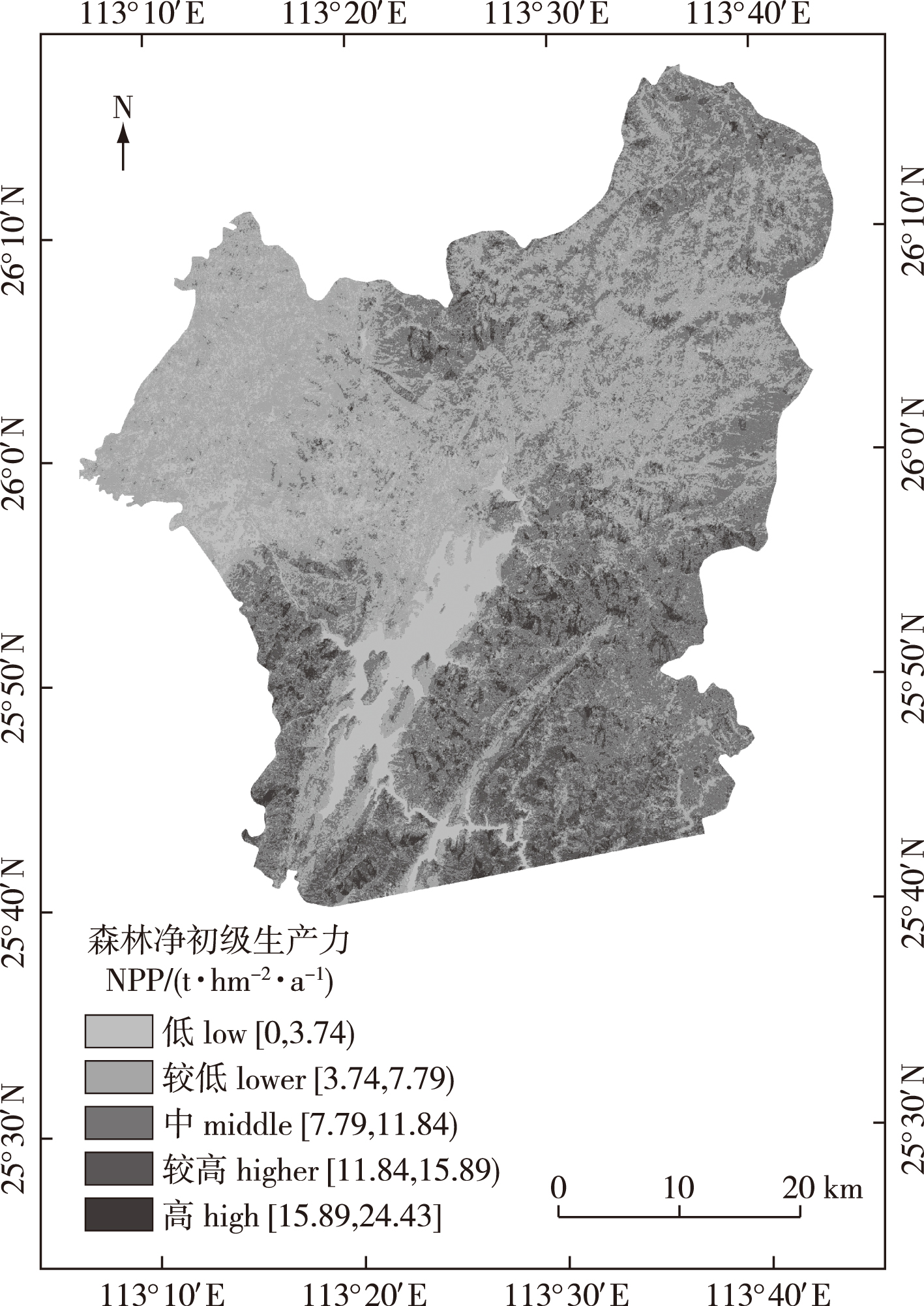
【目的】利用Sentinel-1 & 2主被动遥感数据结合森林冠层高度,对区域森林净初级生产力(NPP)进行高效、准确的估测,为森林精准经营措施以及“双碳”目标的制定提供科学依据。【方法】以南方重点林区资兴市为研究区,基于Sentinel-1和Sentinel-2主被动遥感数据,采用了多元逐步回归、人工神经网络、K最邻近、随机森林4种模型估算NPP。在此基础上加入了Sentinel-1通过InSAR与SRTM DEM差分得到的冠层高度,分析其对NPP估测精度的影响。【结果】①研究区2019年的森林NPP均值为7.79 t/hm2,呈中南部高、西北低的空间分布特征。②4种模型中,主被动遥感结合估测NPP的精度均高于单源遥感方式;随机森林估测区域森林NPP的精度最高,模型表现最好。③加入冠层高度可一定程度提高森林NPP估测精度,R2从0.70提高到了0.75。【结论】基于Sentinel 1 & 2主被动遥感数据并结合DEM差分法获取的冠层高度因子,可有效提高NPP估测精度。

Abstract

【Objective】Using open source active and passive remote sensing data (Sentinel-1 & -2) combined with forest canopy height can improve the estimation accuracy of forest net primary productivity (NPP), to provide a scientific basis for the formulation of forest precision management stragtegies and a “carbon peaking and carbon neutrality” strategy.【Method】Zixing City, which is a key forest area in the south, was used as the research area. Based on Sentinel-1 and Sentinel-2 active and passive remote sensing data, four models, namely multiple stepwise regression, artificial neural network, K-nearest neighbor, and random forest, were used to estimate NPP. On this basis, the canopy height obtained by Sentinel-1 through the difference between InSAR and SRTM DEM was added to analyze its effect on the accuracy of NPP estimation.【Result】(1) The mean value of forest NPP in the study area in 2019 was 7.79 t/hm2, showing the spatial distribution characteristics of high in the central southwest and low in the northwest. (2) Among the four models, the accuracy of NPP estimation by active and passive remote sensing was higher than that by single remote sensing; the accuracy of random forest estimation of regional forest NPP was the highest, and the model performed the best. (3) Adding canopy height improved the estimation accuracy of forest NPP to a certain extent, with R2 increased from 0.70 to 0.75.【Conclusion】The accuracy of NPP estimation can be improved based on Sentinel active and passive remote sensing data and canopy height factor, which is obtained by DEM difference method.

关键词

森林净初级生产力 / Sentinel-1 / Sentinel-2 / ICESat-2 / 森林冠层高度 / 资兴市 / 智慧林业 / 森林精准经营

Key words

forest net primary productivity / sentinel data / ICESat-2 / forest canopy height / Zixing City / smart forestry and forest precision management

引用本文

导出引用
田春红, 李明阳, 李陶, . 基于Sentinel 1 & 2主被动遥感数据和冠层高度的森林净初级生产力估测[J]. 南京林业大学学报(自然科学版). 2024, 48(4): 132-140 https://doi.org/10.12302/j.issn.1000-2006.202205014
TIAN Chunhong, LI Mingyang, LI Tao, et al. Estimation of forest net primary productivity based on sentinel active and passive remote sensing data and canopy height[J]. JOURNAL OF NANJING FORESTRY UNIVERSITY. 2024, 48(4): 132-140 https://doi.org/10.12302/j.issn.1000-2006.202205014
中图分类号: S757   

参考文献

[1]
陈利军, 刘高焕, 励惠国. 中国植被净第一性生产力遥感动态监测[J]. 遥感学报, 2002, 6(2):129-135.
CHEN L J, LIU G H, LI H G. Estimating net primary productivity of’ terrestrial vegetation in China using remote sensing[J]. J Remote Sens, 2002, 6(2):129-135, 164.
[2]
刘国华, 傅伯杰, 方精云. 中国森林碳动态及其对全球碳平衡的贡献[J]. 生态学报, 2000, 20(5):733-740.
LIU G H, FU B J, FANG J Y. Carbon dynamics of Chinese forests and its contribution to global carbon balance[J]. Acta Ecol Sin, 2000, 20(5):733-740. DOI: 10.3321/j.issn:1000-0933.2000.05.004.
[3]
朱文泉, 潘耀忠, 张锦水. 中国陆地植被净初级生产力遥感估算[J]. 植物生态学报, 2007, 31(3):413-424.
ZHU W Q, PAN Y Z, ZHANG J S. Estimation of net primary productivity of Chinese terrestrial vegetation based on remote sensing[J]. J Plant Ecol, 2007, 31(3):413-424. DOI: 10.17521/cjpe.2007.0050.
[4]
郭睿妍, 田佳, 杨志玲, 等. 基于GEE平台的黄河流域森林植被净初级生产力时空变化特征[J]. 生态学报, 2022, 42(13):5437-5445.
GUO R Y, TIAN J, YANG Z L, et al. Spatio-temporal variation characteristics of forest net primary productivity in the Yellow River basin based on Google Earth Engine cloud platform[J]. Acta Ecol Sin, 2022, 42(13):5437-5445. DOI: 10.5846/stxb202104271113.
[5]
RAFIQUE R, ZHAO F, DE JONG R, et al. Global and regional variability and change in terrestrial ecosystems net primary production and NDVI: a model-data comparison[J]. Remote Sens, 2016, 8(3):177. DOI: 10.3390/rs8030177.
[6]
SANNIGRAHI S. Modeling terrestrial ecosystem productivity of an estuarine ecosystem in the Sundarban Biosphere region,India using seven ecosystem models[J]. Ecol Model, 2017, 356:73-90. DOI: 10.1016/j.ecolmodel.2017.03.003.
[7]
林文鹏, 王臣立, 赵敏, 等. 基于森林清查和遥感的城市森林净初级生产力估算[J]. 生态环境, 2008, 17(2):766-770.
LIN W P, WANG C L, ZHAO M, et al. Estimation urban forests NPP based on forest inventory data and remote sensing[J]. Ecol Environ, 2008, 17(2):766-770. DOI: 10.16258/j.cnki.1674-5906.2008.02.076.
[8]
TAN K, ZHOU S Y, LI E Z, et al. Assessing the impact of urbanization on net primary productivity using multi-scale remote sensing data: a case study of Xuzhou, China[J]. Front Earth Sci. 2015, 9(2):319-329. DOI: 10.1007/s11707-014-0454-7.
[9]
REICH P B, TURNER D P, BOLSTAD P. An approach to spatially distributed modeling of net primary production (NPP) at the landscape scale and its application in validation of EOS NPP products[J]. Remote Sens Environ, 1999, 70(1):69-81. DOI: 10.1016/S0034-4257(99)00058-9.
[10]
SHANG E P, XU E Q, ZHANG H Q, et al. Analysis of spatiotemporal dynamics of the Chinese vegetation net primary productivity from the 1960s to the 2000s[J]. Remote Sens, 2018, 10(6):860. DOI: 10.3390/rs10060860.
[11]
李陶, 李明阳, 钱春花. 结合冠层密度的森林净初级生产力遥感估测[J]. 南京林业大学学报(自然科学版), 2021, 45(5):153-160.
LI T, LI M Y, QIAN C H. Combining crown density to estimate forest net primary productivity by using remote sensing data[J]. J Nanjing For Univ (Nat Sci Ed), 2021, 45(5):153-160. DOI: 10.12302/j.issn.1000-2006.202008007.
[12]
MA H, SONG J L, WANG J D, et al. Comparison of the inversion ability in extrapolating forest canopy height by integration of LiDAR data and different optical remote sensing products[C]// 2012 IEEE International Geoscience and Remote Sensing Symposium.Munich, Germany: IEEE, 2012:3363-3366. DOI: 10.1109/IGARSS.2012.6350700.
[13]
李登秋. 亚热带森林碳收支变化特征及其成因模拟分析[D]. 南京: 南京大学, 2014.
LI D Q. Variations of forest carbon budget and underlying driving forces in the subtropical area of China: a case study for Jiangxi Province[D]. Nanjing: Nanjing University, 2014.
[14]
史瑶. 基于MSPA和MCR模型的资兴市生态网络构建研究[D]. 长沙: 中南林业科技大学, 2019.
SHI Y. Ecological network construction and research using MSPA and MCR models in Zixing City, Hunan Province, China[D]. Changsha: Central South University of Forestry & Technology, 2019.
[15]
李轲敏, 傅丽华, 郭湘. 资兴市自然保护地空间冲突与重构研究[J]. 湖南工业大学学报, 2022, 36(2):86-94.
LI K M, FU L H, GUO X. Research on spatial conflict and reconstruction of protected natural areas in Zixing City[J]. J Hunan Univ Technol, 2022, 36(2):86-94. DOI: 10.3969/j.issn.1673-9833.2022.02.012.
[16]
余超, 王斌, 刘华, 等. 中国森林植被净生产量及平均生产力动态变化分析[J]. 林业科学研究, 2014, 27(4):542-550.
YU C, WANG B, LIU H, et al. Dynamic change of net production and mean net primary productivity of China’s forests[J]. For Res, 2014, 27(4):542-550. DOI: 10.13275/j.cnki.lykxyj.2014.04.016.
[17]
温小荣, 蒋丽秀, 刘磊, 等. 江苏省森林生物量与生产力估算及空间分布格局分析[J]. 西北林学院学报, 2014, 29(1):36-40.
WEN X R, JIANG L X, LIU L, et al. Estimation of forest biomass, net primary production and analysis on spatial distribution pattern for Jiangsu Province[J]. J Northwest For Univ, 2014, 29(1):36-40. DOI: 10.3969/j.issn.1001-7461.2014.01.07.
[18]
董佳臣, 倪文俭, 张志玉, 等. ICESat-2植被冠层高度和地表高程数据产品用于森林高度提取的效果评价[J]. 遥感学报, 2021, 25(6):1294-1307.
DONG J C, NI W J, ZHANG Z Y, et al. Performance of ICESat-2 ATL08 product on the estimation of forest height by referencing to small footprint LiDAR data[J]. Natl Remote Sens Bull, 2021, 25(6):1294-1307. DOI: 10.11834/jrs.202194491.
[19]
孙美美. 黄土丘陵区三种典型森林类型生产力形成及影响因素[D]. 杨凌: 西北农林科技大学, 2021.
SUN M M. Net primary productivity and its influencing factors in three typical forest types in the loess hilly region[D]. Yangling: Northwest A&F University, 2021.
[20]
黄昕. 高分辨率遥感影像多尺度纹理、形状特征提取与面向对象分类研究[D]. 武汉: 武汉大学, 2009.
HUANG X. Multiscale texture and shape feature extraction and object-oriented classification for very high resolution remotely sensed imagery[D]. Wuhan: Wuhan University, 2009.
[21]
刘俊, 毕华兴, 朱沛林, 等. 基于ALOS遥感数据纹理及纹理指数的柞树蓄积量估测[J]. 农业机械学报, 2014, 45(7):245-254.
LIU J, BI H X, ZHU P L, et al. Estimating stand volume of Xylosma racemosum forest based on texture parameters and derivative texture indices of ALOS imagery[J]. Trans Chin Soc Agric Mach, 2014, 45(7):245-254. DOI: 10.6041/j.issn.1000-1298.2014.07.038
[22]
陈琳. 基于光学和干涉雷达的森林地上生物量遥感估算模型研究[D]. 长春: 中国科学院大学(中国科学院东北地理与农业生态研究所), 2020.
CHEN L. Modeling of forest aboveground biomass based on optical and interferometric synthetic aperture radar[D]. Changchun: Northeast Institute of Geography and Agroecology, Chinese Academy of Sciences, 2020.
[23]
KENYI L W, DUBAYAH R, HOFTON M, et al. Comparative analysis of SRTM-NED vegetation canopy height to LIDAR-derived vegetation canopy metrics[J]. Int J Remote Sens, 2009, 30(11):2797-2811. DOI: 10.1080/01431160802555853.
[24]
NI W J, GUO Z F, SUN G Q, et al. Investigation of forest height Retrieval using SRTM-DEM and ASTER-GDEM[C]// 30th IEEE International Geoscience and Remote Sensing Symposium (IGARSS) on Remote Sensing-Global Vision for Local Action: 20102111- 2114. DOI: 10.1109/IGARSS.2010.5651443.
[25]
BALLHORN U, JUBANSKI J, SIEGERT F. ICESat/GLAS data as a measurement tool for peatland topography and peat swamp forest biomass in Kalimantan, Indonesia[J]. Remote Sens, 2011, 3(9):1957-1982. DOI: 10.3390/rs3091957.
[26]
范文义, 张海玉, 于颖, 等. 三种森林生物量估测模型的比较分析[J]. 植物生态学报, 2011, 35(4):402-410.
FAN W Y, ZHANG H Y, YU Y, et al. Comparison of three models of forest biomass estimation[J]. Chin J Plant Ecol, 2011, 35(4):402-410. DOI: 10.3724/SP.J.1258.2011.00402.
[27]
陈尔学, 李增元, 武红敢, 等. 基于k-NN和Landsat数据的小面积统计单元森林蓄积估测方法[J]. 林业科学研究, 2008, 21(6):745-750.
CHEN E X, LI Z Y, WU H G, et al. Forest volume estimation method for small areas based on k-NN and Landsat data[J]. For Res, 2008, 21(6):745-750. DOI: 10.3321/j.issn:1001-1498.2008.06.002.
[28]
LI T, LI M Y, REN F, et al. Estimation and spatio-temporal change analysis of NPP in subtropical forests: a case study of Shaoguan, Guangdong, China[J]. Remote Sens, 2022, 14(11):2541.DOI: 10.3390/rs14112541.
[29]
李欣海. 随机森林模型在分类与回归分析中的应用[J]. 应用昆虫学报, 2013, 50(4):1190-1197.
LI X H. Using “random forest” for classification and regression[J]. Chin J Appl Entomol, 2013, 50(4):1190-1197.DOI: 10.7679/j.issn.2095-1353.2013.163.
[30]
BOLÓN-CANEDO V, SÁNCHEZ-MAROÑO N, ALONSO-BETANZOS A. Feature selection for high-dimensional data[J]. Prog Artif Intell, 2016, 5(2):65-75.DOI: 10.1007/s13748-015-0080-y.
[31]
潘磊, 孙玉军, 王轶夫, 等. 基于Sentinel-1和Sentinel-2数据的杉木林地上生物量估算[J]. 南京林业大学学报(自然科学版), 2020, 44(3):149-156.
PAN L, SUN Y J, WANG Y F, et al. Estimation of aboveground biomass in a Chinese fir(Cunninghamia lanceolata)forest combining data of Sentinel-1 and Sentinel-2[J]. J Nanjing For Univ (Nat Sci Ed), 2020, 44(3):149-156.DOI: 10.3969/j.issn.1000-2006.201811012.
[32]
SERVIA H, PAREETH S, MICHAILOVSKY C I, et al. Operational framework to predict field level crop biomass using remote sensing and data driven models[J]. Int J Appl Earth Obs Geoinf, 2022, 108:102725.DOI: 10.1016/j.jag.2022.102725.
[33]
高志强, 刘纪远. 中国植被净生产力的比较研究[J]. 科学通报, 2008, 53(3):317-326.
GAO Z Q, LIU J Y. Comparative study on net productivity of vegetation in China[J]. Chin Sci Bull, 2008, 53(3):317-326. DOI: 10.1360/csb2008-53-3-317.
[34]
陈晓玲, 曾永年. 亚热带山地丘陵区植被NPP时空变化及其与气候因子的关系:以湖南省为例[J]. 地理学报, 2016, 71(1):35-48.
CHEN X L, ZENG Y N. Spatial and temporal variability of the net primary production (NPP) and its relationship with climate factors in subtropical mountainous and hilly regions of China: a case study in Hunan Province[J]. Acta Geogr Sin, 2016, 71(1):35-48.DOI: 10.11821/dlxb201601003.
[35]
闫妍, 覃金华, 房磊, 等. 湖南省植被净初级生产力时空动态及其与气候因素的关系[J]. 生态学杂志, 2022, 41(8):1535-1544.
YAN Y, QIN J H, FANG L, et al. Spatiotemporal dynamics of vegetation net primary productivity and its relationships with climatic factors in Hunan Province[J]. Chin J Ecol, 2022, 41(8):1535-1544. DOI: 10.13292/j.1000-4890.202208.015.
[36]
江源通. 湘江流域植被NPP时空动态及影响因素分析[D]. 湘潭: 湖南科技大学, 2015.
JIANG Y T. Analysis of spatio-temporal dynamics and factors influencing vegetation NPP in Xiangjiang River basin[D]. Xiangtan: Hunan University of Science and Technology, 2015.
[37]
张骏. 中国中亚热带东部森林生态系统生产力和碳储量研究[D]. 杭州: 浙江大学, 2008.
ZHANG J. NPP and carbon storage in subtropical forest,eastern China[D]. Hangzhou: Zhejiang University, 2008.

基金

国家自然科学基金项目(31770679)

编辑: 郑琰燚
PDF(1801 KB)

Accesses

Citation

Detail

段落导航
相关文章

/