 PDF(14482 KB)

基于GIS-AHP与视域断面分析的浙西南自然保护地富集区游憩风景道规划
唐晓岚, 张杰, 周铭杰, 宋天锐
南京林业大学学报(自然科学版) ›› 2025, Vol. 49 ›› Issue (2) : 221-232.
PDF(14482 KB)
 PDF(14482 KB)
基于GIS-AHP与视域断面分析的浙西南自然保护地富集区游憩风景道规划
Planning of recreational scenic roads abundant region in southwest Zhejiang nature reserve based on GIS-AHP and longitudinal view section analysis
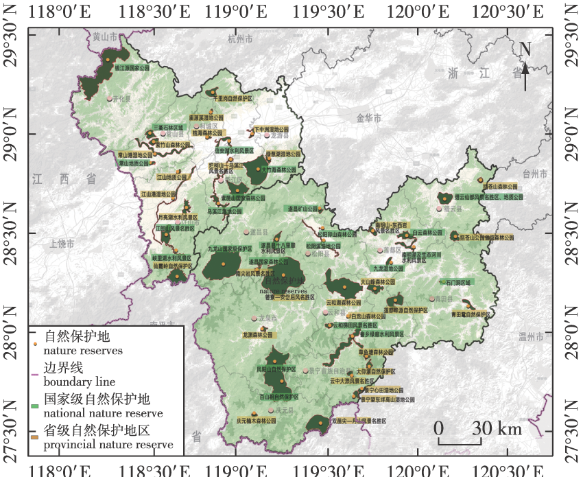
【目的】风景道建设顺应了自然保护地资源整合和全域旅游的发展趋势,以自然保护地富集区游憩资源入手,从区域角度出发探索一套游憩风景道的选线规划方法和思路。【方法】运用AHP法与ArcGIS空间分析,结合定量评价指标体系,建立研究区潜在风景道综合体系,初步筛选浙西南自然保护地富集区潜在风景道,结合视域断面分析主要风景道特色。【结果】通过GIS空间分析,得出每条潜在风景道的评价结果,最终结合现状,叠加分析,得到23条潜在风景道,根据选线影响因素的综合评价,选出G205、G235、S222等10条最优风景道;同时将浙西南游憩风景道分为一级、二级、三级,直观地描述每级风景道的特征。【结论】将浙西南地区游憩风景道规划为“2+6+7+N”的建设格局,即围绕两大国家公园作为核心区域,6条主要风景道作为沟通廊道,串联区域内7个生态游憩区,呈现多条支线廊道陈列其间的格局。同时对其中主要游憩风景道的视域断面分析进行相应主题设计,为浙西南地区风景道网络科学选线提供理论依据与数据支撑。
【Objective】This study addresses the construction of scenic trails, aligning with the trend of resource integration in abundant region of nature reserves and the growth of global tourism. It begins with the recreational resources of abundant region of nature reserves and puts forward a comprehensive set of methods for selecting and planning recreational scenic trails from a regional perspective. This is intended to fill gaps in existing theoretical research on scenic trails at both the resource and regional levels within nature reserves. 【Method】Utilizing the analytic hierarchy process (AHP) and ArcGIS spatial analysis, potential scenic roads were preliminarily screened. Combined with the natural and human geographical characteristics of the study area, comprehensive evaluations of potential scenic roads were conducted. Key features of these roads were then summarized using visual field sections. 【Result】GIS spatial analysis yielded evaluations of each potential scenic road. After considering the current conditions and conducting overlay analysis, 23 potential scenic roads were identified. The comprehensive assessment of factors influencing route selection revealed 10 optimal scenic roads, including G205, G235, S222, among others. Furthermore, recreational scenic roads in southwestern Zhejiang were classified into three levels, with the distinct characteristics of each level described intuitively. 【Conclusion】The recreational scenic roads in the southwest of Zhejiang Province are meticulously planned according to a “2+6+7+N” construction pattern. This involves two national parks serving as core areas, six primary scenic roads functioning as communication corridors, and seven ecological recreation areas being interconnected in a series. Additionally, numerous branch corridors are prominently displayed. Concurrently, a visual area section analysis of these main recreational scenic roads has been designed, offering a theoretical foundation and data support for the scientific selection of scenic road routes in southwest Zhejiang.
GIS-AHP法 / 视域断面分析 / 游憩风景道 / 游憩资源 / 浙西南 / 自然保护地富集区
geographic information system-analytic hierarchy process (GIS-AHP) method / longitudinal view section analysis / scenic road / recreational resources / southwest Zhejiang / abundatn region of nature reserve
| [1] |
余青, 樊欣, 刘志敏, 等. 国外风景道的理论与实践[J]. 旅游学刊, 2006, 21(5):91-95.
|
| [2] |
|
| [3] |
张朝枝, 曹静茵, 罗意林. 旅游还是游憩?我国国家公园的公众利用表述方式反思[J]. 自然资源学报, 2019, 34(9):1797-1806.
|
| [4] |
张圆刚, 陈希, 余润哲, 等. 线型旅游体验空间:风景道的体验性逻理嬗变[J]. 自然资源学报, 2020, 35(2):284-296.
|
| [5] |
侯琳, 张丹, 李磊峰. 浅析成德区域骑游绿道选线建设[J]. 云南地理环境研究, 2017, 29(3):35-40.
|
| [6] |
|
| [7] |
|
| [8] |
|
| [9] |
吴必虎, 李咪咪. 小兴安岭风景道旅游景观评价[J]. 地理学报, 2001, 56(2):214-222.
|
| [10] |
魏遐, 白梅, 鞠远江. 基于景观评价的高速公路风景道旅游规划:以福宁高速风景道为例[J]. 经济地理, 2007, 27(1):161-165,156.
|
| [11] |
崔晨. 基于地理热力图的风景道景观评价:以北京市延庆区百里画廊为例[J]. 文化月刊, 2019(8):132-137.
|
| [12] |
姚朋, 孙一豪, 奚秋蕙, 等. 耦合多元价值的生态风景道规划研究:以乌兰察布四横交通带风景道为例[J]. 中国园林, 2019, 35(4):101-106.
|
| [13] |
李果, 钟静玲. 全域旅游背景下长株潭地区风景道开发潜力评价[J]. 公路, 2021, 66(12):288-295.
|
| [14] |
叶文, 马有明, 杨殷迪. 绿色通道在保护地游憩规划中的应用研究:以西双版纳热带雨林国家公园绿道规划设计为例[J]. 旅游研究, 2011, 3(1):32-36.
|
| [15] |
朱高儒, 衷平, 程逸楠, 等. 四川康定“川藏木雅” 风景道景观规划设计[J]. 交通标准化, 2014(3):11-15.
|
| [16] |
唐晓岚, 刘小涵, 刘政. 基于GIS-AHP的皖南山区风景道选线研究[J]. 内蒙古农业大学学报(自然科学版), 2020, 41(5):25-31.
|
| [17] |
余青, 宫连虎. 风景道游憩服务设施建设研究:以美国蓝岭风景道为例[J]. 中外公路, 2010, 30(3):14-19.
|
| [18] |
胡传东, 李露苗, 罗尚焜. 基于网络游记内容分析的风景道骑行体验研究:以318国道川藏线为例[J]. 旅游学刊, 2015, 30(11):99-110.
|
| [19] |
朱高儒, 衷平, 徐洪磊, 等. 试论中国国家风景道体系的构建[J]. 公路, 2015, 60(9):156-162.
|
| [20] |
孙盼盼, 余青. 基于政策文本量化分析的我国风景道政策演进特征研究[J]. 公路交通科技, 2021, 38(2):146-158.
|
| [21] |
徐颖, 张淑萍. 论全域旅游背景下我国旅游风景道的建设发展[J]. 齐齐哈尔大学学报(哲学社会科学版), 2022(2):68-71.
|
| [22] |
李磊, 徐婷, 王涵, 等. 风景道的交通文化价值:挖掘、整合与重构:以哈密东天山风景道规划为例[J]. 公路交通科技, 2020, 37(S1):96-102.
|
| [23] |
钟其. 浙西南山区城镇化发展路径研究[J]. 浙江学刊, 2015(5):213-218.
|
| [24] |
肖练练, 钟林生, 虞虎, 等. 功能约束条件下的钱江源国家公园体制试点区游憩利用适宜性评价研究[J]. 生态学报, 2019, 39(4):1375-1384.
|
| [25] |
陈尚超. 城市仿真:一种交互式规划和公众参与的创新工具[J]. 城市规划, 2001, 25(8):34-36.
|
| [26] |
王颖, 王云, 孔亚平, 等. 基于层次分析法和模糊数学的中巴喀喇昆仑公路沿线景观综合评价[J]. 生态科学, 2014, 33(6):1106-1113.
|
| [27] |
张颖, 杨志耕. 江西省三清山森林游憩资源价值评价[J]. 中国人口·资源与环境, 2011, 21(S2):221-225.
|
| [28] |
刘润, 李巍, 尹秀, 等. 藏区大尺度同质景观格局背景下风景道的建构研究:以甘南藏族自治州为例[J]. 开发研究, 2012(1):109-112.
|
| [29] |
马坤, 唐晓岚, 王奕文, 等. 小尺度丘陵山地风景区游览路线的规划与优化[J]. 南京林业大学学报(自然科学版), 2020, 44(1):163-170.
|
| [30] |
李东和, 吴润华, 张莹. 我国风景道研究综述[J]. 资源开发与市场, 2018, 34(2):292-296.
|
/
| 〈 |
|
〉 |


