GEDI与ICESat-2星载激光雷达数据反演树高研究

孔得伦, 邢艳秋

南京林业大学学报(自然科学版) ›› 2025, Vol. 49 ›› Issue (2) : 175-184.

PDF(3223 KB)
PDF(3223 KB)
南京林业大学学报(自然科学版) ›› 2025, Vol. 49 ›› Issue (2) : 175-184. DOI: 10.12302/j.issn.1000-2006.202309009
研究论文

GEDI与ICESat-2星载激光雷达数据反演树高研究

作者信息 +

Inversion of tree height from GEDI and ICESat-2 spaceborne lidar

Author information +
文章历史 +

摘要

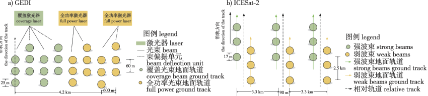
【目的】全球生态系统动力学调查(GEDI)多波束激光雷达与冰、云和陆地高程卫星二代(ICESat-2) 光子云使用不同激光雷达技术,导致两个任务之间的树高提取值存在差异。比较两种星载激光雷达数据在不同情况下有效反演树高的能力,为空间连续大区域高分辨率森林树高制图提供理论基础。【方法】通过对GEDI L2A字段信息进行定位和筛选,并进行地形高程精度验证,对比6种算法组反演树高;对ICESat-2数据去噪并提出基于坡度变化的光子云分类算法,建立地面光子线和冠层顶线反演树高,利用实测数据和机载激光雷达数据,验证并比较GEDI和ICESat-2在研究区内反演树高的精度。最后,定量分析GEDI和ICESat-2数据在不同地形坡度、植被覆盖度和森林类型情况下反演树高的差异。【结果】针对GEDI L2A产品数据,通过比较6组GEDI L2A算法中最优算法的反演精度为:R2=0.94,均方根误差(RMSE)为2.31 m,绝对平均误差(MAE)为1.27 m。针对ICESat-2 数据,通过使用50 m窗口计算,基于坡度变化的光子云分类算法提取树高与机载树高的R2=0.81,RMSE为3.68 m,MAE为2.45 m。植被覆盖度相对于地形坡度和森林类型对两种星载激光雷达反演树高产生更大的影响。【结论】对于较为平缓且森林类型以针叶林为主的较密集区域,其GEDI数据相比于ICESat-2数据表现出更优的评价精度。

Abstract

【Objective】Global ecosystem dynamics investigation (GEDI) multibeam lidar and ice, cloud and land elevation satellite-2 (ICESat-2) photon clouds use different lidar technologies, resulting in differences in tree height extraction values between the two tasks. The purpose of this study is to compare the ability of two spaceborne lidar data to effectively invert forest height under different conditions. 【Method】By locating and filtering the GEDI L2A field information, and verifying the terrain elevation accuracy, the tree height of six algorithm groups was compared. The ICESat-2 data was denoised, a photonic cloud classification algorithm based on slope change was proposed, the ground photon line and the canopy top line inversion forest height were established, and the accuracy of GEDI and ICESat-2 in the study area was verified and compared by using the measured data and airborne lidar data. Finally, the differences of GEDI and ICESat-2 data in different terrain slopes, vegetation coverage and forest types were quantitatively analyzed. 【Result】According to the GEDI L2A product data, by comparing the optimal algorithms in GEDI L2A algorithm group from a1 to a6, the inversion accuracy of a4 was better: R2=0.94, root mean square error was 2.31 m, and mean absolute error was 1.27 m. For ICESat-2 data, R2=0.81, the root mean square error was 3.68 m, and the mean absolute error was 2.45 m, calculated using a 50 m window. Vegetation coverage had a greater impact on the tree height of the two spaceborne lidars compared to the terrain slope and forest type. 【Conclusion】Compared with ICESat-2 data, GEDI data showed a better evaluation accuracy standard for the more gentle and densely populated areas with coniferous forest types.

关键词

全球生态系统动力学调查(GEDI) / 冰、云和陆地高程卫星二代(ICESat-2) / 反演树高 / 地形坡度 / 植被覆盖度 / 森林类型 / 星载激光雷达

Key words

global ecosystem dynamics investigation(GEDI) / ice, cloud and land elevation satellite-2 (ICESat-2) / invert tree height / terrain slope / vegetation coverage / forest type / spaceborne LiDAR

引用本文

导出引用
孔得伦, 邢艳秋. GEDI与ICESat-2星载激光雷达数据反演树高研究[J]. 南京林业大学学报(自然科学版). 2025, 49(2): 175-184 https://doi.org/10.12302/j.issn.1000-2006.202309009
KONG Delun, XING Yanqiu. Inversion of tree height from GEDI and ICESat-2 spaceborne lidar[J]. JOURNAL OF NANJING FORESTRY UNIVERSITY. 2025, 49(2): 175-184 https://doi.org/10.12302/j.issn.1000-2006.202309009
中图分类号: S771.8   

参考文献

[1]
HAYASHI M, SAIGUSA N, OGUMA H, et al. Measuring forest canopy height using ICESat/GLAS data for applying to Japanese spaceborne lidar mission[C]// Lidar Remote Sensing for Environmental Monitoring XIII.Kyoto,Japan.SPICE, 2012,8526:85260.DOI:10.1117/12.981583.
[2]
URBAZAEV M, HESS L L, HANCOCK S, et al. Assessment of terrain elevation estimates from ICESat-2 and GEDI spaceborne LiDAR missions across different land cover and forest types[J]. Sci Remote Sens, 2022,6:100067. DOI:10.1016/j.srs.2022.100067.
[3]
MA L, HURTT G, TANG H, et al. Spatial heterogeneity of global forest aboveground carbon stocks and fluxes constrained by spaceborne lidar data and mechanistic modeling[J]. Glob Chang Biol, 2023, 29(12):3378-3394.DOI:10.1111/gcb.16682.
[4]
SUN T, QI J B, HUANG H G. Discovering forest height changes based on spaceborne lidar data of ICESat-1 in 2005 and ICESat-2 in 2019:a case study in the Beijing-Tianjin-Hebei region of China[J]. For Ecosyst, 2020, 7(1):53. DOI:10.1186/s40663-020-00265-w.
[5]
LIN X D, SHANG R, CHEN J M, et al. High-resolution forest age mapping based on forest height maps derived from GEDI and ICESat-2 space-borne lidar data[J]. Agric For Meteor, 2023,339:109592. DOI:10.1016/j.agrformet.2023.109592.
[6]
ZHU W D, YANG F, QIU Z G, et al. Enhancing forest canopy height retrieval: insights from integrated GEDI and Landsat data Analysis[J]. Sustainability, 2023, 15(13):10434.DOI:10.3390/su151310434.
[7]
胡艳, 王迪, 刘凌菲, 等. 利用大光斑激光雷达估测小兴安岭平均树高[J]. 安徽农业科学, 2014, 42(15):4707-4709.
HU Y, WANG D, LIU L F, et al. Estimation of forest tree average heights from GLAS data in lesser Khingan mountains[J]. J Anhui Agric Sci, 2014, 42(15):4707-4709.DOI:10.13989/j.cnki.0517-6611.2014.15.094.
[8]
董瀚元, 于颖, 范文义. 星载激光雷达GEDI数据林下地形反演性能验证[J]. 南京林业大学学报(自然科学版), 2023, 47(2):141-149.
DONG H Y, YU Y, FAN W Y. Verification of performance of understory terrain inversion from spaceborne lidar GEDI data[J]. J Nanjing For Univ (Nat Sci Ed), 2023, 47(2):141-149.
[9]
吴伟东. 联合卫星遥感影像与光子雷达数提取山林地区数字高程模型[D]. 广州: 广东工业大学, 2022.
WU W D. Extraction of digital elevation model in mountain forest area by combining satellite remote sensing image and photon radar number[D]. Guangzhou: Guangdong University of Technology, 2022.
[10]
黄佳鹏. 基于ICESat-2/ATLAS光子计数LiDAR数据反演森林冠层高度研究[D]. 哈尔滨: 东北林业大学, 2021.
HUANG J P. Inversion of forest canopy height based on ICESat-2/ATLAS photon counting LiDAR data[D].Harbin: Northeast Forestry University, 2021.DOI: 10.27009/d.cnki.gdblu.2021.000073.
[11]
覃志刚, 尤号田, 黄元威, 等. 不同植被覆盖区ICESat-2和GF-7卫星地表高程信息对比研究[J]. 航天返回与遥感, 2023, 44(5):91-104.
QIN Z G, YOU H T, HUANG Y W, et al. Research on comparsion of surface elevation information of different vegetation cover types based on ICESat-2 and GF-7 satellite data[J]. Spacecr Recovery Remote Sens, 2023, 44(5):91-104.DOI: 10.3969/j.issn.1009-8518.2023.05.011.
[12]
张少伟. 基于多源数据的内蒙古大兴安岭林区森林资源变化监测研究[D]. 北京: 中国林业科学研究院, 2019.
ZHANG S W. Monitoring of forest resources change in Daxinganling forest region of Inner Mongolia based on multi-source data[D]. Beijing: Chinese Academy of Forestry, 2019.
[13]
GUPTA R, SHARMA L K. Mixed tropical forests canopy height mapping from spaceborne LiDAR GEDI and multisensor imagery using machine learning models[J]. Remote Sens Appl Soc Environ, 2022, 27(2):100817.DOI:10.1016/j.rsase.2022.100817.
[14]
DUBAYAH R, BLAIR J B, GOETZ S, et al. The global ecosystem dynamics investigation:high-resolution laser ranging of the earth’s forests and topography[J]. Sci Remote Sens, 2020,1:100002.DOI:10.1016/j.srs.2020.100002.
[15]
MARKUS T, NEUMANN T, MARTINO A, et al. The ice,cloud, and land elevation satellite-2 (ICESat-2):science requirements,concept,and implementation[J]. Remote Sens Environ, 2017, 190:260-273.DOI:10.1016/j.rse.2016.12.029.
[16]
陆大进, 黎东, 朱笑笑, 等. 基于卷积神经网络的ICESat-2光子点云去噪分类[J]. 地球信息科学学报, 2021, 23(11):2086-2095.
LU D J, LI D, ZHU X X, et al. Denoising and classification of ICESat-2 photon point cloud based on convolutional neural network[J]. J Geo Inf Sci, 2021, 23(11):2086-2095.
[17]
NEUENSCHWANDER A, PITTS K. The ATL08 land and vegetation product for the ICESat-2 Mission[J]. Remote Sens Environ, 2019, 221:247-259.DOI:10.1016/j.rse.2018.11.005.
[18]
ZOU S, PAN H, ZOU Z, et al. ICESat-2 laser altimetry data-guided high-accuracy positioning of satellite stereo images[J]. ISPRS Ann Photogramm Remote Sens Spatial Inf Sci, 2022, 41(1):41-48.DOI:10.5194/isprs-annals-V-1-2022-41-2022.
[19]
陈雨莹, 王龑, 邹艳红, 等. 全球土地覆盖产品中森林类型数据在中国区域的质量评估[J]. 遥感技术与应用, 2023, 38(2):341-352.
CHEN Y Y, WANG Y, ZOU Y H, et al. Assessment of forest type data in global land cover products over China[J]. Remote Sens Technol Appl, 2023, 38(2):341-352.DOI: 10.11873/j.issn.1004-0323.2023.2.0341.
[20]
ZHU X X, NIE S, WANG C, et al. Consistency analysis of forest height retrievals between GEDI and ICESat-2[J]. Remote Sens Environ, 2022,281:113244.DOI:10.1016/j.rse.2022.113244.
[21]
韩明辉, 邢艳秋, 李国元, 等. GEDI不同算法组数据反演森林最大冠层高度和生物量精度比较[J]. 中南林业科技大学学报, 2022, 42(10):72-82.
HAN M H, XING Y Q, LI G Y, et al. Comparison of the accuracy of the maximum canopy height and biomass inversion of the data of different GEDI algorithm groups[J]. J Cent South Univ For Technol, 2022, 42(10):72-82. DOI: 10.14067/j.cnki.1673-923x.2022.10.009.
[22]
秦磊. 基于ICESat-2星载激光雷达光子云数据反演森林冠层高度方法研究[D]. 哈尔滨: 东北林业大学, 2020.
QIN L. Study on the method of retrieving forest canopy height based on the photon cloud data of ICESat-2 spaceborne lidar[D].Harbin: Northeast Forestry University, 2020.
[23]
王丽, 李毅, 朱建军, 等. ICESat-2 ATL08地形和冠层高度产品精度评估[J]. 遥感信息, 2023, 38(4): 144-152.
WANG L, LI Y, ZHU J J, et al. Accuracy assessment of ICESat-2 ATL08 terrain and canopy heights[J]. Remote Sens Info, 2023, 38(4): 144-152.DOI:10.20091/j.cnki.1000-3177.2023.04.018.

基金

国家重点研发计划(SQ2021YFE010728)

编辑: 李燕文
PDF(3223 KB)

Accesses

Citation

Detail

段落导航
相关文章

/