 PDF(4550 KB)
 PDF(4550 KB)
 PDF(4550 KB)
基于多源数据的南京市公园降温效应研究
Research on the cooling effect of parks in Nanjing based on multi-source data
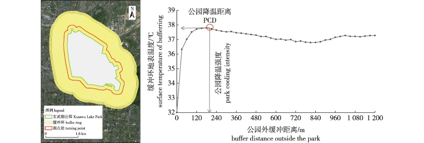
【目的】 利用拐点法量化公园的降温效应,并确定具有高效降温效应的公园面积和周长阈值范围,基于多源数据综合考虑城市公园的内部和外部特征对其降温效应的影响。【方法】 基于2019年9月13日Landsat-8遥感影像,采用辐射传输法反演地表温度;基于高分二号遥感影像,采用随机森林法进行土地覆被分类;基于百度地图兴趣面(area of interest,AOI)获取83个公园边界。利用拐点法得到公园的降温强度和降温距离,利用相关性分析和SHAP分析,从公园内景观特征、公园内环境特征和公园外环境特征3个方面探讨影响因子与公园降温效应之间的关系。【结果】 ①公园的降温面积阈值为18~19 hm2,周长阈值在1.9~2.0 km。②公园内部的建设用地高占比和较高的斑块密度会削弱公园降温效应,而水体和绿地的占比则可增强公园降温效应;面积加权周长比越小的公园越有助于公园降温效应的发挥。③公园内植被结构参数和生理特征对降温效应有显著影响,植被冠层越高、长势越好,降温距离越远;土壤含水量对降温效应至关重要。④公园外部较高的建筑高度和高道路密度会削弱公园降温效应。【结论】 公园的降温效应受到公园内外景观特征和环境特征的影响。可以通过提高公园景观的完整性、合理配置绿地水体和培育优质植被等措施来改善公园降温效应,从而缓解城市热岛效应。
【Objective】 The study aimed to quantify the cooling effect of parks using the inflection point method, and to determine the area and perimeter thresholds of parks with an efficient cooling effect. The internal and external characteristics of urban parks and their influence on the cooling effect was analyzed based on multi-source data. 【Method】 The radiative transfer method was used to retrieve the surface temperature from Landsat-8 remote sensing images on September 13, 2019, and the land cover was classified using the random forest method based on Gaofen-2 remote sensing images. The area of interest (AOI) on the Baidu map was used to determine the boundaries of 83 parks. The inflection point method was used to determine the cooling intensity and cooling distances of parks. The relationship between the cooling effect of parks and three influencing factors, namely, features of the landscape, internal park environment, and external park environment, was determined by correlation analysis and the SHAP analysis. 【Result】 The cooling threshold of parks encompassed an area of 18-19 hm2 with a perimeter of about 1.9-2.0 km. The results of feature indicator analysis revealed that the cooling effect of parks can be reduced by a high proportion of construction land and a high patch density within the parks, but enhanced by a high proportion of waterbodies and green spaces. Parks with a smaller area-weighted perimeter ratio had a higher cooling efficiency. The structural parameters and physiological characteristics of the vegetation had a significant influence on the cooling effect of parks. The cooling distances of parks increased was higher in the proportion of vegetation with better growth and greater canopy height. Soil moisture also played a crucial role in the cooling effect of parks. However, the cooling effect was weakened by the presence of surrounding buildings of greater height and a higher road density outside the parks. 【Conclusion】 The cooling effect of parks is influenced by internal and external landscape features and environmental characteristics. The cooling effect of parks can be enhanced by improving the integrity of the landscape, ensuring the distribution of green spaces and waterbodies, and cultivating high-quality vegetation, to mitigater the urban heat island effect.
城市公园 / 城市热岛 / 冷岛效应 / 多源数据 / 拐点法 / SHAP分析 / 南京
city parks / urban heat island / cold island effect / multi-source data / inflection point method / SHAP analysis / Nanjing City
| [1] |
|
| [2] |
胡欣雨. 南阳市主城区热岛效应及绿地降温作用研究[D]. 福州: 福建农林大学, 2022.
|
| [3] |
|
| [4] |
倪黎, 沈守云, 黄培森. 园林绿化对降低城市热岛效应的作用[J]. 中南林业科技大学学报, 2007, 27(2):36-43.
|
| [5] |
|
| [6] |
|
| [7] |
赵海月, 胡淼, 朱建宁, 等. 高密度中心城区蓝绿空间冷岛效应及其影响因素:以北京五环路以内地区为例[J]. 生态学报, 2023, 43(12):4904-4919.
|
| [8] |
|
| [9] |
|
| [10] |
|
| [11] |
|
| [12] |
|
| [13] |
|
| [14] |
|
| [15] |
|
| [16] |
|
| [17] |
|
| [18] |
孙燕, 濮梅娟, 张备, 等. 南京夏季高温日数异常的分析[J]. 气象科学, 2010, 30(2):279-284.
|
| [19] |
|
| [20] |
|
| [21] |
|
| [22] |
赵芮, 申鑫杰, 田国行, 等. 郑州市公园绿地景观特征对公园冷岛效应的影响[J]. 生态学报, 2020, 40(9):2886-2894.
|
| [23] |
|
| [24] |
江海英, 柴琳娜, 贾坤, 等. 联合PROSAIL模型和植被水分指数的低矮植被含水量估算[J]. 遥感学报, 2021, 25(4):1025-1036.
|
| [25] |
|
| [26] |
|
| [27] |
韩煜娜, 左德鹏, 王国庆, 等. 变化环境下青藏高原陆地水储量演变格局及归因[J]. 水资源保护, 2023, 39(2):199-207,214.
|
| [28] |
王新军, 冯星莹, 陈凯莉, 等. 城市公园的冷岛效应研究:以常州市为例[J]. 中国环境科学, 2021, 41(9):4245-4252.
|
| [29] |
|
| [30] |
姚春生, 张增祥, 汪潇. 使用温度植被干旱指数法(TVDI)反演新疆土壤湿度[J]. 遥感技术与应用, 2004, 19(6):473-478.
|
| [31] |
|
/
| 〈 |
|
〉 |


