基于MSPA和MCR模型的贺兰山生态安全网络评价与优化

叶洁楠, 黄亦周, 贾舒皓, 李坤, 张辰帅, 吴露涵, 李雨珊, 王浩

南京林业大学学报(自然科学版) ›› 2025, Vol. 49 ›› Issue (5) : 217-226.

PDF(8555 KB)
PDF(8555 KB)
南京林业大学学报(自然科学版) ›› 2025, Vol. 49 ›› Issue (5) : 217-226. DOI: 10.12302/j.issn.1000-2006.202406001
研究论文

基于MSPA和MCR模型的贺兰山生态安全网络评价与优化

作者信息 +

Evaluation and optimization of the ecological security network of Helan Mountain based on MSPA and MCR models

Author information +
文章历史 +

摘要

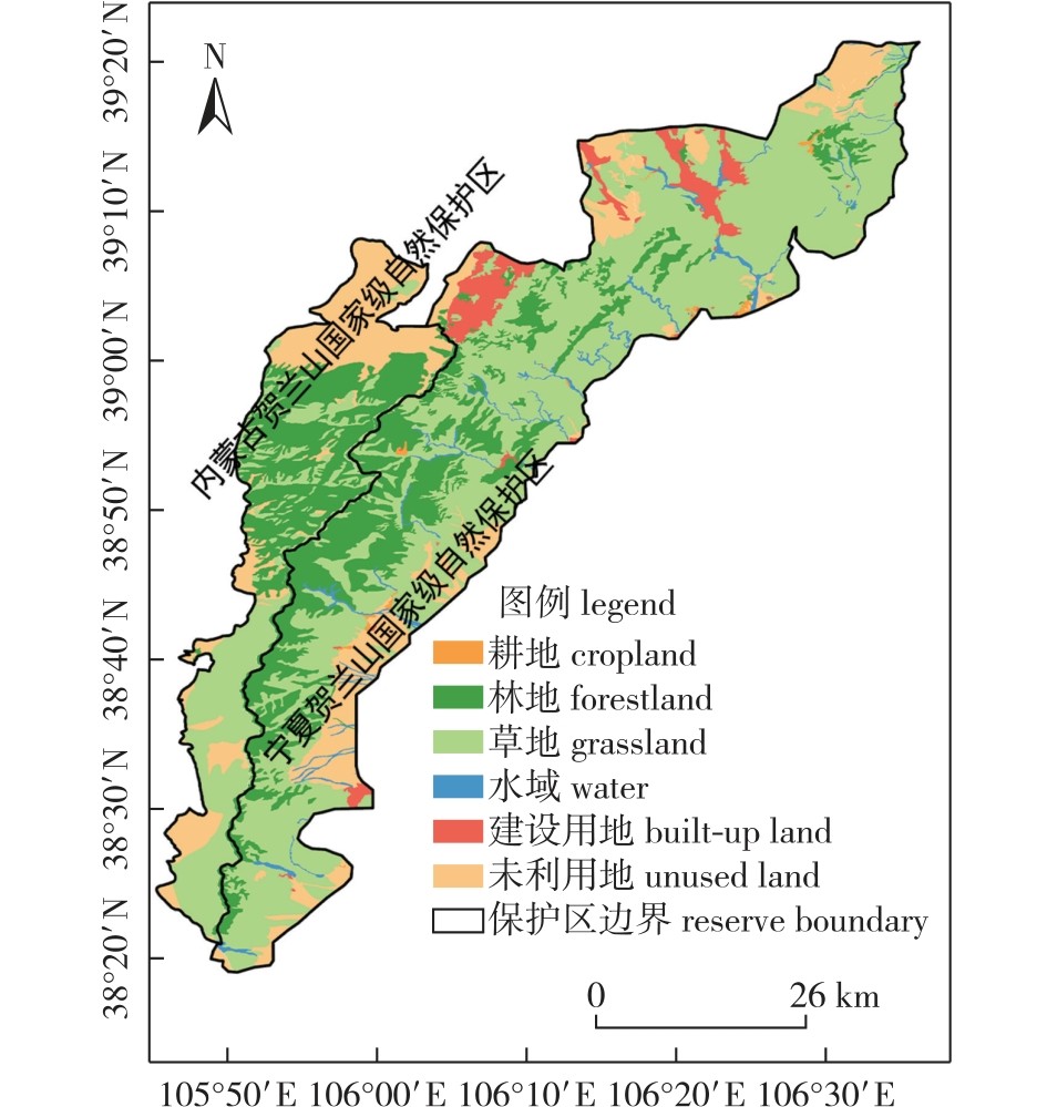
【目的】自然保护区正面临着生态环境保护与经济开发协调统一的问题。通过构建生态网络以保持生态源地间的完整性、连通性、稳定性和生物多样性,进而促进物种恢复和栖息地修复,为自然保护区景观格局的保护与优化提供科学依据。【方法】以贺兰山为研究区域,通过形态学空间格局分析(MSPA)法解析并选取高生态价值的林地作为核心区;运用景观连通性评价方法对核心区生态源地的连通性进行排序并最终确定连通性最高的重要生态源地;提取与研究区相关的6个阻力因子,通过最小累积阻力(MCR)模型和重力模型模拟生态廊道;结合水文分析识别生态节点,构建研究区生态安全网络。【结果】贺兰山共有重要生态源地15个,总面积为44 766 hm2,集中在中部和南部地区;在区域内确立了一般生态廊道31条、重要生态廊道16条,能够有效地连接所有生态源地并确保物种交流;确定了91个生态节点,其中43个暂歇点、35个战略点及13个断裂点。研究区内大部分生态安全网络呈现较高的连通性与完整性。【结论】贺兰山的生态安全格局可分为核心保护区、生态缓冲区和可持续利用区,对不同区域采取差异化管理策略,可为自然保护区的生态功能优化和空间协调规划提供参考,推动其生物多样性保护和生态系统的可持续发展。

Abstract

【Objective】Nature reserves face conflicts between ecological conservation and economic development. By establishing ecological networks to maintain the integrity, connectivity, stability, and biodiversity of ecological sources, species recovery and habitat restoration can be ensured. This approach provides a scientific foundation for the protection and development of the Helan Mountains.【Method】Taking the Helan Mountain as the study area, we identified ecologically valuable forest lands as core areas using the morphological spatial pattern analysis (MSPA). Ranked core areas by connectivity significance through landscape connectivity assessment.Extracted six resistance factors and simulated ecological corridors via the minimum cumulative resistance (MCR) and the gravity models. Identified ecological nodes through hydrological analysis to construct the ecological security network.【Result】The Helan Mountains comprises 15 significant ecological sources covering with a total area of 44 766 hm2, which are concentrated in the central and southern regions. Thirty-one general ecological corridors and 16 critical ecological corridors were identified within the area, effectively connecting all ecological sources and ensuring species exchange. Ninety-one ecological nodes were identified, including 43 temporary rest points, 35 strategic points, and 13 breakpoints; most of the ecological security networks within the study area shows high connectivity and integrity.【Conclusion】The ecological security pattern of the Helan Mountains can be zoned into core protection areas, ecological buffer zones, and sustainable use areas. Differentiated management strategies for different areas can provide references for optimizing the ecological functions of the nature reserve and spatial coordination planning, promotes the protection of biodiversity and sustainable development of ecosystems in the nature reserve.

关键词

自然保护区 / 形态学空间格局分析法(MSPA) / 最小累积阻力模型(MCR) / 生态源地 / 生态廊道 / 生态安全网络 / 贺兰山

Key words

nature reserve / morphological spatial pattern analysis (MSPA) / minimum cumulative resistance (MCR) model / ecological source areas / ecological corridors / ecological security network / Helan Mountain

引用本文

导出引用
叶洁楠, 黄亦周, 贾舒皓, . 基于MSPA和MCR模型的贺兰山生态安全网络评价与优化[J]. 南京林业大学学报(自然科学版). 2025, 49(5): 217-226 https://doi.org/10.12302/j.issn.1000-2006.202406001
YE Jienan, HUANG Yizhou, JIA Shuhao, et al. Evaluation and optimization of the ecological security network of Helan Mountain based on MSPA and MCR models[J]. JOURNAL OF NANJING FORESTRY UNIVERSITY. 2025, 49(5): 217-226 https://doi.org/10.12302/j.issn.1000-2006.202406001
中图分类号: S759.92   

参考文献

[1]
刘畅. 可持续发展理念下的生态安全格局建构:评《中国生态安全格局构建与评价》[J]. 安全与环境学报, 2024, 24(2):819.
LIU C. Construction of ecological security pattern under the concept of sustainable development:comment on construction and evaluation of ecological security pattern in China[J]. Journal of Safety and Environment, 2024, 24(2):819.
[2]
郑群明, 扈嘉辉, 申明智. 基于MSPA和MCR模型的湖南省生态网络构建[J]. 湖南师范大学自然科学学报, 2021, 44(5):1-10.
ZHENG Q M, HU J H, SHEN M Z. Construction of ecological network in Hunan Province based on MSPA and MCR models[J]. Journal of Natural Science of Hunan Normal University, 2021, 44(5):1-10.DOI: 10.7612/j.issn.2096-5281.2021.05.001.
[3]
陈竹安, 马彬彬, 危小建, 等. 基于MSPA和MCR模型的南昌市生态网络构建与优化[J]. 水土保持通报, 2021, 41(6):139-147.
CHEN Z A, MA B B, WEI X J, et al. Construction and optimization of ecological network of Nanchang City based on MSPA and MCR model[J]. Bulletin of Soil and Water Conservation, 2021, 41(6):139-147.DOI: 10.13961/j.cnki.stbctb.2021.06.020.
[4]
于颖, 孟京辉, 宋增明, 等. 基于MCR模型和景观连通性的县域生态网络构建[J]. 南京林业大学学报(自然科学版), 2023, 47(4):226-234.
YU Y, MENG J H, SONG Z M, et al. Construction of ecological network in Xinfeng based on MCR model and landscape connectivity[J]. Journal of Nanjing Forestry University (Natural Sciences Edition), 2023, 47(4):226-234.
[5]
胡西武, 贾天朝. 基于生态敏感性与景观连通性的三江源国家公园生态安全格局构建与优化[J]. 长江流域资源与环境, 2023, 32(8):1724-1735.
HU X W, JIA T C. Construction and optimization of ecological security pattern in three-river-source National Park based on ecological sensitivity and landscape connectivity[J]. Resources and Environment in the Yangtze Basin, 2023, 32(8):1724-1735.DOI: 10.11870/cjlyzyyhj202308015.
[6]
王越, 赵雯琳, 刘纯青. 基于MSPA-Conefor-MCR路径的生态网络优化及其构建:以彭泽县为例[J]. 江西农业大学学报, 2022, 44(2):504-518.
WANG Y, ZHAO W L, LIU C Q. Optimization and construction of ecological network based on MSPA-conefor-MCR path:a case study of Pengze County[J]. Acta Agriculturae Universitatis Jiangxiensis, 2022, 44(2):504-518.DOI: 10.13836/j.jjau.2022052.
[7]
陈静, 左翔, 彭建松, 等. 基于MSPA与景观连通性分析的城市生态网络构建:以保山市隆阳区为例[J]. 西部林业科学, 2020, 49(4):118-123.
CHEN J, ZUO X, PENG J S, et al. Construction of urban ecological networks based on MSPA and landscape connectivity analysis:a case study in Longyang District[J]. Journal of West China Forestry Science, 2020, 49(4):118-123.DOI: 10.16473/j.cnki.xblykx1972.2020.04.017.
[8]
TANG Y H, GAO C, WU X F. Urban ecological corridor network construction:an integration of the least cost path model and the InVEST model[J]. ISPRS International Journal of Geo-Information, 2020, 9(1):33.DOI: 10.3390/ijgi9010033.
[9]
包瑾, 刘学录, 刘星雨, 等. 基于电路理论的河西走廊生态安全格局构建[J/OL]. 甘肃农业大学学报, 2024:1-19.(2024-01-15). https://kns.cnki.net/kcms/detail/62.1055.S.20240115.1033.002.html.
BAO J, LIU X L, LIU X Y, et al. Construction of ecological security pattern in Hexi Corridor based on circuit theory[J/OL]. Journal of Gansu Agricultural University, 2024:1-19.(2024-01-15). https://kns.cnki.net/kcms/detail/62.1055.S.20240115.1033.002.html.
[10]
QIN J Z, DAI J P, LI S H, et al. Construction of ecological network in Qujing City based on MSPA and MCR models[J]. Scientific Reports, 2024, 14:9800.DOI: 10.1038/s41598-024-60048-z.
[11]
LIU J, CHEN J J, YANG Y P, et al. Construction and optimization of an ecological network in the Yellow River source region based on MSPA and MCR modelling[J]. International Journal of Environmental Research and Public Health, 2023, 20(4):3724.DOI: 10.3390/ijerph20043724.
[12]
张亮, 岳文泽, 陈阳. 基于斑块复合属性特征的城市生态安全格局构建:以杭州市为例[J]. 生态学报, 2021, 41(11):4632-4640.
ZHANG L, YUE W Z, CHEN Y. Construction of urban ecological security pattern based on of patch composite characteristics:a case study of Hangzhou[J]. ActaEcologica Sinica, 2021, 41(11):4632-4640.DOI: 10.5846/stxb201906101220.
[13]
王晓峰, 朱梦娜, 张欣蓉, 等. 基于“源地-阻力-廊道” 的三江源区生态安全格局构建[J]. 生态学报, 2024, 44(11):4609-4623.
WANG X F, ZHU M N, ZHANG X R, et al. Ecological security pattern construction of the Three-river Source Region based on Source-Resistance-Corridor[J]. ActaEcologica Sinica, 2024, 44(11):4609-4623.DOI: 10.20103/j.stxb.202309282107.
[14]
梁坤宇, 金晓斌, 张晓琳, 等. 耦合生态系统服务供需的生态安全格局构建:以苏南地区为例[J]. 生态学报, 2024, 44(9):3880-3896.
LIANG K Y, JIN X B, ZHANG X L, et al. Construction of ecological security patterns coupling supply and demand of ecosystem services:a case study of Southern Jiangsu Province[J]. ActaEcologica Sinica, 2024, 44(9):3880-3896.DOI: 10.20103/j.stxb.202307271608.
[15]
ZHANG X M, DU H M, WANG Y, et al. Watershed landscape ecological risk assessment and landscape pattern optimization:take Fujiang River basin as an example[J]. Human and Ecological Risk Assessment:an International Journal, 2021, 27(9/10):2254-2276.DOI: 10.1080/10807039.2021.1970511.
[16]
李慧杰, 李婉婷, 王兵, 等. 宁夏贺兰山国家级自然保护区生态系统服务功能评估[J]. 林草资源研究, 2024(1):25-33.
LI H J, LI W T, WANG B, et al. Assessment of ecosystem services in Helan MountainNational Nature Reserve in Ningxia[J]. Forest and Grassland Resources Research, 2024(1):25-33.DOI: 10.13466/j.cnki.lczyyj.2024.01.004.
[17]
刘振生, 高惠, 滕丽微, 等. 基于MAXENT模型的贺兰山岩羊生境适宜性评价[J]. 生态学报, 2013, 33(22):7243-7249.
LIU Z S, GAO H, TENG L W, et al. Habitat suitability assessment of blue sheep in Helan Mountain based on MAXENT modeling[J]. Acta Ecologica Sinica, 2013, 33(22):7243-7249.DOI: 10.5846/stxb201207221041.
[18]
周梦云, 蔡永立, 张瑞峰, 等. 宁夏贺兰山国家级自然保护区建立前后区域生态脆弱性时空格局变化研究[J]. 生态科学, 2019, 38(5):78-85.
ZHOU M Y, CAI Y L, ZHANG R F, et al. The tempo-spatial pattern of regional ecological vulnerability before and after the establishment of National Nature Reserve in Helan Mountain of Ningxia[J]. Ecological Science, 2019, 38(5):78-85.DOI: 10.14108/j.cnki.1008-8873.2019.05.011.
[19]
高宇, 木皓可, 张云路, 等. 基于MSPA分析方法的市域尺度绿色网络体系构建路径优化研究:以招远市为例[J]. 生态学报, 2019, 39(20):7547-7556.
GAO Y, MU H K, ZHANG Y L, et al. Research on construction path optimization of urban-scale green network system based on MSPA analysis method:taking Zhaoyuan City as an example[J]. ActaEcologica Sinica, 2019, 39(20):7547-7556.DOI: 10.5846/stxb201905050907.
[20]
宁琦, 朱梓铭, 覃盟琳, 等. 基于MSPA和电路理论的南宁市国土空间生态网络优化研究[J]. 广西大学学报(自然科学版), 2021, 46(2):306-318.
NING Q, ZHU Z M, QIN M L, et al. Research on the optimization of territorial space ecological network of Nanning City based on MSPA and circuit theory[J]. Journal of Guangxi University (Natural Science Edition), 2021, 46(2):306-318.DOI: 10.13624/j.cnki.issn.1001-7445.2021.0306.
[21]
刘一丁, 何政伟, 陈俊华, 等. 基于MSPA与MCR模型的生态网络构建方法研究:以南充市为例[J]. 西南农业学报, 2021, 34(2):354-363.
LIU Y D, HE Z W, CHEN J H, et al. Ecological network construction method based on MSPA and MCR model:taking Nanchong as example[J]. Southwest China Journal of Agricultural Sciences, 2021, 34(2):354-363.DOI: 10.16213/j.cnki.scjas.2021.2.019.
[22]
吴昌广, 周志翔, 王鹏程, 等. 景观连接度的概念、度量及其应用[J]. 生态学报, 2010, 30(7):1903-1910.
WU C G, ZHOU Z X, WANG P C, et al. The concept and measurement of landscape connectivity and its applications[J]. ActaEcologica Sinica, 2010, 30(7):1903-1910.DOI: 10.20103/j.stxb.2010.07.029.
[23]
DUAN J Q, CAO Y, LIU B, et al. Construction of an ecological security pattern in Yangtze River Delta based on circuit theory[J]. Sustainability, 2023, 15(16):12374.DOI: 10.3390/su151612374.
[24]
赵良飞, 王旭, 王永刚, 等. 基于MCR模型的神东矿区景观生态安全格局构建研究[J]. 能源环境保护, 2020, 34(6):81-88.
ZHAO L F, WANG X, WANG Y G, et al. Construction of landscapeecological security pattern of Shendong Mineral Area based on the mini-mum cumulative resistance model[J]. Energy Environmental Protection, 2020, 34(6):81-88.
[25]
唐晓岚, 王忆梅, 周孔飞. 基于生态安全格局的山岳型风景区景观资源保护利用研究[J]. 南京林业大学学报(自然科学版), 2023, 47(2):178-186.
TANG X L, WANG Y M, ZHOU K F. Protection and utilization of landscape resources in mountainous scenic areas based on ecological security patterns[J]. Journal of Nanjing Forestry University (Natural Sciences Edition), 2023, 47(2):178-186.
[26]
刘芳, 张星梓, 任静, 等. 基于生态系统服务评价与最小阻力模型的生态安全格局构建:以临沧市为例[J]. 环境科学导刊, 2021, 40(4):78-83.
LIU F, ZHANG X Z, REN J, et al. Construction of ecological security pattern based on ecosystem service evaluation and minimum resistance model:a case study of Lincang City[J]. Environmental Science Survey, 2021, 40(4):78-83.DOI: 10.13623/j.cnki.hkdk.2021.04.011.
[27]
徐新良, 刘纪远, 张树文, 等. 中国多时期土地利用土地覆被遥感监测数据集(CNLUCC)[DS/OL].[2024-05-15]. 中国科学院地理科学与资源研究所数据注册与出版系统, 2018.
XU X L, LIU J Y, ZHANG S W, et al. Multi-period land use and land cover remote sensing monitoring dataset in China (CNLUCC)[DS/OL].[2024-05-15]. Data Registration and Publishing System of the Institute of Geographic Sciences and Natural Resources Research, Chinese Academy of Sciences, 2018. DOI:10.12078/2018070201.]
[28]
LIU J Y, LIU M L, DENG X Z, et al. The land use and land cover change database and its relative studies in China[J]. Journal of Geographical Sciences, 2002, 12(3):275-282.DOI: 10.1007/BF02837545.
[29]
YANG J L, DONG J W, XIAO X M, et al. Divergent shifts in peak photosynthesis timing of temperate and alpine grasslands in China[J]. RemoteSensing of Environment, 2019, 233:111395.DOI: 10.1016/j.rse.2019.111395.
[30]
韩冰, 韩轶, 秦富仓, 等. 内蒙古土默特左旗生态网络构建与优化:基于MSPA与MCR模型分析[J]. 中国城市林业, 2023, 21(6):113-120.
HAN B, HAN Y, QIN F C, et al. Construction and optimization of ecological network based on MSPA and MCR models in Tumertzuo Banner,Inner Mongolia[J]. Journal of Chinese Urban Forestry, 2023, 21(6):113-120.
[31]
成文浩, 李同昇, 马彩虹. 基于MCR模型和DO指数的宁夏沿黄生态经济带生态安全格局构建[J]. 西北大学学报(自然科学版), 2022, 52(3):433-443.
CHENG W H, LI T S, MA C H. Construction of an ecological security pattern based on MCR model and DO index:a case study of the ecological and economic belt along the Yellow River in Ningxia[J]. Journal of Northwest University (Natural Science Edition), 2022, 52(3):433-443.DOI: 10.16152/j.cnki.xdxbzr.2022-03-008.
[32]
郭韩悦阳, 刘嘉纬, 陈春旭. 云南省澜沧江流域自然保护地生态网络构建[J]. 水土保持通报, 2023, 43(2):193-201.
GUO H Y Y, LIU J W, CHEN C X. Construction of an ecological network of natural reserves in Lancang River Basin,Yunnan Province[J]. Bulletin of Soil and Water Conservation, 2023, 43(2):193-201.DOI: 10.13961/j.cnki.stbctb.20230425.001.
[33]
LI Y Y, ZHANG Y Z, JIANG Z Y, et al. Integrating morphological spatial pattern analysis and the minimal cumulative resistance model to optimize urban ecological networks:a case study in Shenzhen City,China[J]. Ecological Processes, 2021, 10(1):63.DOI: 10.1186/s13717-021-00332-2.
[34]
周汝波, 林媚珍, 吴卓, 等. 基于生态系统服务重要性的粤港澳大湾区生态安全格局构建[J]. 生态经济, 2020, 36(7):189-196.
ZHOU R B, LIN M Z, WU Z, et al. Construction of ecological security in Guangdong-Hong Kong-Macao greater bay area from the perspective of importance of ecosystem services[J]. Ecological Economy, 2020, 36(7):189-196.
[35]
LI Y M, ZHAO J Z, YUAN J, et al. Constructing the ecological security pattern of Nujiang prefecture based on the framework of “importance-sensitivity-connectivity”[J]. International Journal of Environmental Research and Public Health, 2022, 19(17):10869.DOI: 10.3390/ijerph191710869.
[36]
黄荷. 生态网络构建视角下的庐山市城市绿地系统规划研究[D]. 南昌: 江西农业大学, 2022. DOI: 10.27177/d.cnki.gjxnu.2022.000333.
HUANG H. Study on urban green space system planning of Lushan city from the perspective of ecological network construction[D]. Nanchang: Jiangxi Agricultural University, 2022. DOI: 10.27177/d.cnki.gjxnu.2022.000333.
[37]
李纪宏, 刘雪华. 基于最小费用距离模型的自然保护区功能分区[J]. 自然资源学报, 2006, 21(2):217-224.
LI J H, LIU X H. Research of the nature reserve zonation based on the least,cost distance model[J]. Journal of Natural Resources, 2006, 21(2):217-224. DOI: 10.3321/j.issn:1000-3037.2006.02.008.
[38]
邹珮雯, 徐昉. 生态安全格局构建及景观生态风险预测:以赛罕乌拉国家级自然保护区为例[J]. 生态学报, 2023, 43(23):9981-9993.
ZOU P W, XU F. Ecological security pattern construction and landscape ecological risk prediction:a case study of Saihanwula National Nature Reserve[J]. ActaEcologica Sinica, 2023, 43(23):9981-9993.DOI: 10.20103/j.stxb.202211213360.
[39]
邢婷. 基于MSPA与MCR模型的景观生态网络构建与优化:以陕西省宝鸡市为例[J]. 江西科学, 2024, 42(3):531-537.
XING T. Construction and optimization of landscape ecological network based on MSPA and MCR models:a case study of Baoji City,Shaanxi Province[J]. Jiangxi Science, 2024, 42(3):531-537.DOI: 10.13990/j.issn1001-3679.2024.03.012.
[40]
沈润, 史正涛, 何光熊, 等. 基于景观破碎化指数的西双版纳生态安全格局构建与优化[J]. 热带地理, 2022, 42(8):1363-1375.
SHEN R, SHI Z T, HE G X, et al. Construction and optimization of the ecological security pattern of Xishuangbanna based on fragmentation index[J]. Tropical Geography, 2022, 42(8):1363-1375.DOI: 10.13284/j.cnki.rddl.003531.

基金

国家自然科学基金面上项目(32371939)
江苏省社会科学基金后期资助项目(22HQB9)
2023年江苏高校“青蓝工程”优秀青年骨干教师项目

编辑: 郑琰燚
PDF(8555 KB)

Accesses

Citation

Detail

段落导航
相关文章

/