基于尺度转换与重构的FY-3B林火监测影像可视化增强研究

苏维, 尹俊玥, 叶江霞, 周汝良, 温庆忠, 王磊, 李元杰, 赵俊

南京林业大学学报(自然科学版) ›› 2026, Vol. 50 ›› Issue (2) : 37-47.

PDF(4907 KB)
PDF(4907 KB)
南京林业大学学报(自然科学版) ›› 2026, Vol. 50 ›› Issue (2) : 37-47. DOI: 10.12302/j.issn.1000-2006.202408006
专题报道(Ⅰ):森林资源智能感知与精准监测(执行主编 李凤日 曹林 张怀清)

基于尺度转换与重构的FY-3B林火监测影像可视化增强研究

作者信息 +

Research on visualization enhancement of FY-3B image for forest fire monitoring based on scale conversion and reconstruction

Author information +
文章历史 +

摘要

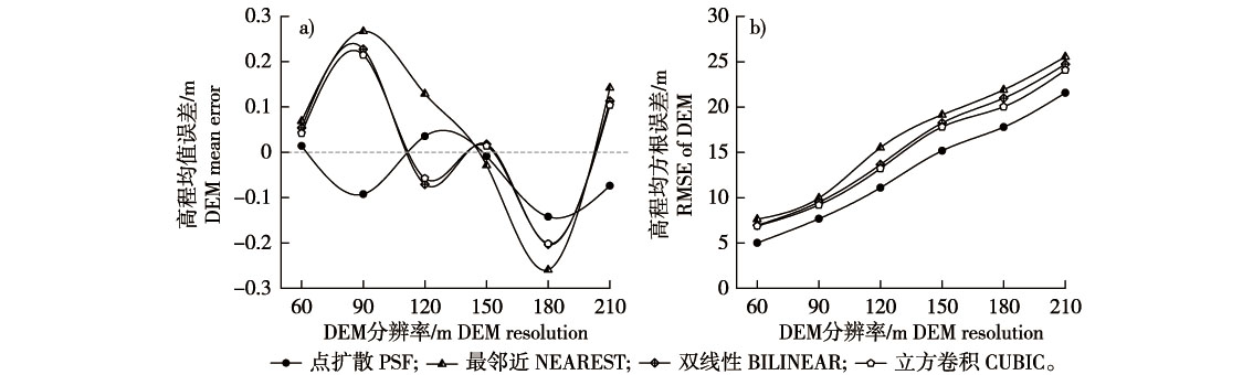
【目的】针对千米级卫星林火监测影像模糊及火场微地形信息缺失问题,研究基于地形尺度转换与影像重构的处理方法,增强影像火环境清晰度与可视化效果,为火场信息快速提取及防灭火决策提供支撑。【方法】以2019年“5·17”昆明市晋宁区双河彝族乡干河村森林火灾和“5·18”曲靖市陆良县小百户镇永清村雨台子山火灾为研究对象,基于FY-3B影像与30 m数字高程模型(DEM)地形数据,利用点扩散函数(point spread function, PSF)与亚像元分解方法构建不同尺度的地形单元,结合信息熵理论确定适宜的重构尺度,借助增加权重的HSV(hue, saturation, value)变换实现正立体地形阴影(shaded relief model, SRM)数据与FY-3B影像融合,并比较上推与下推尺度转换方法的重构效果。【结果】①相较常规插值方法,点扩散函数尺度上推效果更优,高程均值差和均方根误差最小,与原始DEM等高线匹配度最高。②分析上推DEM载荷的地形信息熵表明,研究区适宜的DEM重构尺度为≤120 m。③不同尺度重构影像显著增强了原始1.1 km分辨率FY-3B影像的可视化效果,反立体现象得以校正,提升了对火环境地形细节的表征能力。④15 m尺度融合影像在定量指标和火场地形特征增强效果上表现最佳,林火覆盖面积提取最为准确。【结论】研究通过地形尺度转换与图像重构方法,融合多尺度DEM地形数据,显著提升FY-3B林火监测影像的火环境信息表达能力及可视化效果,为提高卫星林火监测成效和支撑防灭火决策提供了重要支持。针对不同尺度、不同面积范围的卫星林火影像解译与火环境研究,综合考虑更多受灾点区域统计特性,以匹配最佳尺度地形单元,是进一步提升林火监测影像可视化效果的研究方向。

Abstract

【Objective】This study developed a processing method based on terrain scale conversion and image reconstruction to address the challenges of blurred kilometer-scale satellite imagery and the absence of micro-topography information in forest fire monitoring. Aiming to enhance the clarity and visualization effect of the fire environments in satellite images, thereby supporting rapid-fire information extraction and informed decision-making for fire prevention and suppression.【Method】The study focused on two forest fire events: the “5·17” fire in Ganhe Village, Shuanghe Yi Township, Jinning District, Kunming City, and the “5·18” fire in Yutaizi Mountain, Yongqing Village, Xiaobaihu Town, Luliang County, Qujing City, both occurring in 2019. Utilizing FY-3B satellite imagery and 30 m resolution Digital Elevation Model (DEM) data, terrain units at varying scales were constructed using the point spread function (PSF) and sub-pixel decomposition method. The optimal reconstruction scale was determined through information entropy theory. A weighted Hue, Saturation, Value (HSV) transformation was employed to fuse shaded relief model (SRM) data with FY-3B images. The reconstruction effects of the scaling up and scaling down methods were systematically compared.【Result】(1) The PSF-based scaling up method demonstrated superior performance to conventional interpolation techniques, exhibiting the minimum mean elevation error and RMSE and the highest alignment with original DEM contour lines. (2) Terrain information entropy analysis revealed that the optimal DEM reconstruction scale for the study area was ≤120 m. (3) Reconstructed images at multiple scales significantly improved the visualization of the original 1.1 km resolution FY-3B imagery, effectively correcting anti-stereo phenomena and enhancing the representation of terrain details in fire environments. (4) The 15 m scale fused image exhibited the best performance in quantitative metrics, including improved terrain feature contrast and the highest accuracy in forest fire area extraction.【Conclusion】Integrating multi-scale DEM data through terrain scale conversion and image reconstruction methods markedly enhanced the fire environment representation and visualization quality of FY-3B forest fire monitoring imagery. These advancements provide critical technical support for improving satellite-based forest fire monitoring efficacy and optimizing fire management strategies. Future research should explore the statistical characteristics of disaster-affected regions across varying scales to further refine the matching of terrain units for enhanced visualization outcomes.

关键词

林火监测 / 卫星FY-3B / DEM尺度转换 / 图像重构 / 影像可视化增强

Key words

forest fire monitoring / satellite FY-3B / DEM scale conversion / image reconstruction / image visualization enhancement

引用本文

导出引用
苏维, 尹俊玥, 叶江霞, . 基于尺度转换与重构的FY-3B林火监测影像可视化增强研究[J]. 南京林业大学学报(自然科学版). 2026, 50(2): 37-47 https://doi.org/10.12302/j.issn.1000-2006.202408006
SU Wei, YIN Junyue, YE Jiangxia, et al. Research on visualization enhancement of FY-3B image for forest fire monitoring based on scale conversion and reconstruction[J]. Journal of Nanjing Forestry University (Natural Sciences Edition). 2026, 50(2): 37-47 https://doi.org/10.12302/j.issn.1000-2006.202408006
中图分类号: TP75;P931;S757   

参考文献

[1]
何瑞瑞, 赵凤君, 曾玉婷, 等. 多源遥感影像在森林火灾监测中的应用[J]. 世界林业研究, 2022, 35(2):59-63.
HE R R, ZHAO F J, ZENG Y T, et al. Application of multisource remote sensing imagery to forest fire monitoring[J]. World Forestry Research, 2022, 35(2):59-63. DOI: 10.13348/j.cnki.sjlyyj.2021.0097.y.
[2]
ZHENG Y, ZHANG G, TAN S Q, et al. Research on progress of forest fire monitoring with satellite remote sensing[J]. Agricultural & Rural Studies, 2023, 1(2):8. DOI: 10.59978/ar01020008.
[3]
贾斌英. 中国林火卫星遥感监测的应用及评价[J]. 绿色科技, 2021, 23(13):97-98.
JIA B Y. Application and evaluation of forest fire satellite remote sensing monitoring in China[J]. Journal of Green Science and Technology, 2021, 23(13):97-98. DOI: 10.16663/j.cnki.lskj.2021.13.033.
[4]
CHUVIECO E, AGUADO I, SALAS J, et al. Satellite remote sensing contributions to wildland fire science and management[J]. Current Forestry Reports, 2020, 6(2):81-96. DOI: 10.1007/s40725-020-00116-5.
[5]
ABDOLLAHI A, YEBRA M. Forest fuel type classification:review of remote sensing techniques,constraints and future trends[J]. Journal of Environmental Management, 2023, 342:118315. DOI: 10.1016/j.jenvman.2023.118315.
[6]
殷针针, 陈方, 林政阳, 等. 基于FY-3D MERSI数据的火点识别方法研究[J]. 遥感技术与应用, 2020, 35(5):1099-1108.
YIN Z Z, CHEN F, LIN Z Y, et al. Active fire monitoring based on FY-3D MERSI satellite data[J]. Remote Sensing Technology and Application, 2020, 35(5):1099-1108. DOI: 10.11873/j.issn.1004-0323.2020.5.1099.
[7]
BA R, CHEN C, YUAN J, et al. SmokeNet:satellite smoke scene detection using convolutional neural network with spatial and channel-wise attention[J]. Remote Sensing, 2019, 11(14):1702. DOI: 10.3390/rs11141702.
[8]
LIU P, LIU Y X, GUO X X, et al. Burned area detection and mapping using time series Sentinel-2 multispectral images[J]. Remote Sensing of Environment, 2023, 296:113753. DOI: 10.1016/j.rse.2023.113753.
[9]
柴国栋. 基于遥感数据的森林火灾星上实时监测研究[D]. 西安: 西安电子科技大学, 2022.
CHAI G D. On-board real-time monitoring of forest fire based on remote sensing data[D]. Xi’an: Xidian University, 2022.
[10]
BERNABÉ-POVEDA M A, ÇÖLTEKIN A. Prevalence of the terrain reversal effect in satellite imagery[J]. International Journal of Digital Earth, 2015, 8(8):640-655. DOI: 10.1080/17538947.2014.942714.
[11]
ZHANG J H, ZHAO S R, LIANG H, et al. Image super resolution via multi-regularization combining hybrid Tikhonov-TV prior and deep denoiser prior[C]// 2023 IEEE 35th International Conference on Tools with Artificial Intelligence (ICTAI).November 6-8,2023,Atlanta,GA,USA.IEEE, 2023:829-835. DOI: 10.1109/ICTAI59109.2023.00126.
[12]
BASHIR S M A, WANG Y, KHAN M, et al. A comprehensive review of deep learning-based single image super-resolution[J]. Computer Science, 2021, 7:e621. DOI: 10.7717/peerj-cs.621.
[13]
余新宇. 遥感图像的超分辨率重建技术研究[D]. 成都: 电子科技大学, 2013.
YU X Y. Research on super-resolution reconstruction of remote sensing images[D]. Chengdu: University of Electronic Science and Technology of China, 2013.
[14]
石大维, 符冉迪, 金炜. 基于耦合过完备字典的红外云图超分辨率方法[J]. 光电工程, 2014, 41(4):69.
SHI D W, FU R D, JIN W. A method of infrared nephogram super-resolution based on coupled over-completed dictionary[J]. Opto-Electronic Engineering, 2014, 41(4):69. DOI: 10.3969/j.issn.1003-501X.2014.04.011.
[15]
黄诚, 王皓, 王一凯, 等. 基于亚像元分解与增强的MODIS卫星林火监测图像制作[J]. 西部林业科学, 2015, 44(1):82-87.
HUANG C, WANG H, WANG Y K, et al. Forest fire monitoring mapping technology based on sub-pixel decomposition and enhancement[J]. Journal of West China Forestry Science, 2015, 44(1):82-87. DOI: 10.16473/j.cnki.xblykx1972.2015.01.009.
[16]
姜涛, 朱文泉, 周夏飞, 等. 一种融合地形阴影模型和YUV亮度分量的遥感图像反立体校正方法[J]. 北京师范大学学报(自然科学版), 2015, 51(S1):38-43.
JIANG T, ZHU W Q, ZHOU X F, et al. An anti-stereo correction method for remote sensing images based on terrain shadow model and YUV brightness component[J]. Journal of Beijing Normal University (Natural Science), 2015, 51(S1):38-43. DOI: 10.16360/j.cnki.jbnuns.2015.s1.006.
[17]
赵延芳, 王涛, 李鹏, 等. 基于ZY3遥感图像的反立体校正方法研究[J]. 信息技术, 2017, 41(3):60-64.
ZHAO Y F, WANG T, LI P, et al. Image correction methods to remove false topographic perception phenomena (FTPP) of ZY 3 imagery[J]. Information Technology, 2017, 41(3):60-64. DOI: 10.13274/j.cnki.hdzj.2017.03.015.
[18]
何福红, 王涛, 范擎宇, 等. 地形和遥感图像融合技术在冲沟参数提取中的应用:以栖霞市庵里水库东缘流域为例[J]. 地理研究, 2015, 34(11):2124-2132.
HE F H, WANG T, FAN Q Y, et al. Application of a fusion technique that combines topography and remote sensing images for gully extraction:a case study in the eastern watershed of Anli Reservoir,Qixia[J]. Geographical Research, 2015, 34(11):2124-2132. DOI: 10.11821/dlyj201511011.
[19]
张亚南. DEM分辨率确定与尺度转换方法研究[D]. 南京: 南京师范大学, 2014.
ZHANG Y N. Research on DEM resolution determination and scale conversion method[D]. Nanjing: Nanjing Normal University, 2014.
[20]
周婷, 李大军, 刘学军. DEM适宜分辨率及尺度变换方法的研究[J]. 江西测绘, 2017(1):12-14.
ZHOU T, LI D J, LIU X J. Research on appropriate resolution and scale transformation method of DEM[J]. Jiangxi Surveying and Mapping, 2017(1):12-14.
[21]
卢小平, 田继辉, 张剑伟, 等. 多尺度DEM数据的组织与管理方法研究[J]. 测绘通报, 2010(6):12-15.
LU X P, TIAN J H, ZHANG J W, et al. On organization and management of multiscale DEM data[J]. Bulletin of Surveying and Mapping, 2010(6):12-15.
[22]
梁永忠, 葛咏, 王江浩. 基于地统计学的尺度下推方法综述[J]. 遥感技术与应用, 2015, 30(1):1-7.
LIANG Y Z, GE Y, WANG J H. Review of geostatistical-based downscaling[J]. Remote Sensing Technology and Application, 2015, 30(1):1-7. DOI: 10.11873/j.issn.1004-0323.2015.1.0001.
[23]
杨勤科, DAVID J, 郭伟玲, 等. 基于滤波方法的DEM尺度变换方法研究[J]. 水土保持通报, 2008, 28(6):58-62,199.
YANG Q K, JUPP D, GUO W L, et al. Genaralizing the fine resolution DEMs with filtering method[J]. Bulletin of Soil and Water Conservation, 2008, 28(6):58-62,199. DOI: 10.13961/j.cnki.stbctb.2008.06.003.
[24]
于浩, 杨勤科, 张晓萍, 等. 基于小波多尺度分析的DEM数据综合及尺度转换[J]. 地理与地理信息科学, 2009, 25(4):12-16.
YU H, YANG Q K, ZHANG X P, et al. A study of DEM generalization based on wavelet analysis and it scale transformation[J]. Geography and Geo-Information Science, 2009, 25(4):12-16.
[25]
刘学军, 王彦芳, 晋蓓. 利用点扩散函数进行DEM尺度转换[J]. 武汉大学学报(信息科学版), 2009, 34(12):1458-1462.
LIU X J, WANG Y F, JIN B. A upscaling method of digital elevation model with point spread function[J]. Geomatics and Information Science of Wuhan University, 2009, 34(12):1458-1462.
[26]
杜张颖, 陈松林. 不同DEM尺度下推方法的精度差异性分析[J]. 测绘与空间地理信息, 2019, 42(11):66-69,72.
DU Z Y, CHEN S L. Analysis of precision difference in DEM scale-down methods[J]. Geomatics & Spatial Information Technology, 2019, 42(11):66-69,72. DOI: 10.3969/j.issn.1672-5867.2019.11.018.
[27]
王艳霞, 龙晓敏, 丁琨, 等. 一种基于子矩阵灰阶回代的亚像元分解与增强方法[J]. 地理与地理信息科学, 2016, 32(6):12-17,2.
WANG Y X, LONG X M, DING K, et al. Sub pixel decomposition and enhancement based on back substitution of grey scale values in the sub-matrix[J]. Geography and Geo-Information Science, 2016, 32(6):12-17,2. DOI: 10.3969/j.issn.1672-0504.2016.06.003.
[28]
葛美香, 赵军, 仲波, 等. FY-3/VIRR及MERSI与EOS/MODIS植被指数比较与差异原因分析[J]. 遥感技术与应用, 2017, 32(2):262-273.
GE M X, ZHAO J, ZHONG B, et al. Comparison of the vegetation indexes between FY-3/VIRR,FY-3/MERSI and EOS/MODIS data[J]. Remote Sensing Technology and Application, 2017, 32(2):262-273. DOI: 10.11873/j.issn.1004-0323.2017.2.0262.
[29]
梅益君, 王元庆. 基于点扩散函数的多聚焦图像融合方法[J]. 计算机工程, 2007, 33(19):193-195.
MEI Y J, WANG Y Q. Multi-focus image fusion method based on point spread functions[J]. Computer Engineering, 2007, 33(19):193-195. DOI: 10.3969/j.issn.1000-3428.2007.19.068.
[30]
王新涛. 基于空-天遥感数据尺度转换的土壤盐渍化监测方法研究[D]. 杨凌: 西北农林科技大学, 2020.
WANG X T. Study on monitoring method of soil salinization based on scale conversion of space-sky remote sensing data[D]. Yangling: Northwest A & F University, 2020.
[31]
亢新刚. 森林经理学[M]. 4版. 北京: 中国林业出版社, 2011.
KANG X G. Forest management[M]. 4th ed. Beijing: China Forestry Publishing House, 2011.
[32]
朱海金, 杨辉, 刘欣欣. 不同比例尺DEM地形信息容量的探讨[J]. 测绘科学, 2013, 38(3):184-186,189.
ZHU H J, YANG H, LIU X X. Discussion on topographic information capacity from different scales DEMs[J]. Science of Surveying and Mapping, 2013, 38(3):184-186,189. DOI: 10.16251/j.cnki.1009-2307.2013.03.019.
[33]
周婷. 基于代数多重网格的DEM尺度上推及最适宜分辨率确定[D]. 抚州: 东华理工大学, 2018.
ZHOU T. DEM scale upscaling based on algebraic multigrid and determination of optimal resolution[D]. Fuzhou: East China Institute of Technology, 2018.
[34]
HE F, WANG T, GU L, et al. A shaded relief model (SRM) weighted by surface roughness FTPP correction method for remote sensing image[J]. Jokull Journal, 2014, 64(1):136-154.
[35]
张小利, 李雄飞, 李军. 融合图像质量评价指标的相关性分析及性能评估[J]. 自动化学报, 2014, 40(2):306-315.
ZHANG X L, LI X F, LI J. Validation and correlation analysis of metrics for evaluating performance of image fusion[J]. Acta Automatica Sinica, 2014, 40(2):306-315. DOI: 10.3724/SP.J.1004.2014.00306.
[36]
谢翠贞. 基于SRTM3 DEM与ASTER GDEM的DEM融合方法研究[D]. 南昌: 东华理工大学, 2015.
XIE C Z. Research on DEM fusion method based on SRTM3 DEM and ASTER GDEM[D]. Nanchang: East China University of Technology, 2015.
[37]
黄泽纯. 基于统计学习的DEM尺度上推方法研究[D]. 成都: 西南交通大学, 2021.
HUANG Z C. Research on DEM scale up-push method based on statistical learning[D]. Chengdu: Southwest Jiaotong University, 2021.
[38]
郭微. 不同融合方法对遥感影像融合质量的影响[J]. 测绘标准化, 2022, 38(4):41-45.
GUO W. Influence of different fusion methods on the fusion quality of remote sensing image[J]. Standardization of Surveying and Mapping, 2022, 38(4):41-45. DOI: 10.20007/j.cnki.61-1275/P.2022.04.07.

基金

国家自然科学基金项目(31760212)
国家自然科学基金项目(32360392)
国家林业和草原局国家级成果推广项目(2023133128)
云南省教育厅项目(05000/523003)

责任编辑: 孟苗婧
PDF(4907 KB)

Accesses

Citation

Detail

段落导航
相关文章

/