基于Vmamba联合注意力机制的扎龙湿地信息提取与动态监测

王旭, 高心丹

南京林业大学学报(自然科学版) ›› 2026, Vol. 50 ›› Issue (2) : 48-56.

南京林业大学学报(自然科学版) ›› 2026, Vol. 50 ›› Issue (2) : 48-56. DOI: 10.12302/j.issn.1000-2006.202408020
专题报道(Ⅰ):森林资源智能感知与精准监测(执行主编 李凤日 曹 林 张怀清)

基于Vmamba联合注意力机制的扎龙湿地信息提取与动态监测

作者信息 +

Information extracting and dynamic monitoring of Zhalong Wetland based on Vmamba combined attention mechanism

Author information +
文章历史 +

摘要

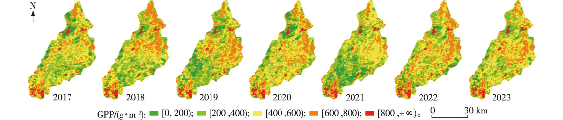
【目的】研究芦苇(Phragmites australis)湿地土地类型变化、监测覆被特征,为湿地保护和开发提供参考。【方法】基于2017—2023年9月扎龙湿地Sentinel-2遥感影像,制作了包含湖泊、芦苇地、建筑地、耕地、盐碱地5种土地类型的遥感影像数据集。通过视觉状态空间(visual state space model,Vmamba)联合注意力机制并结合水体指数NDWI生成水体掩膜对研究区进行信息提取,统计各土地类型的位置和面积变化信息。利用像元二分法提取植被覆盖度(fractional vegetation cover,FVC),计算叶面积指数(leaf area index,LAI)和生态质量指数(ecosystem quality index,EQI)。【结果】通过本研究提出的方法对研究区内分布信息进行提取,整体精度(overall accuracy,OA)为80.85%、平均交并比(mean intersection over union,MIoU)为71.59%,宏观平均F1值(macro-F1,MF1)为79.93%。2017—2023年,在扎龙湿地内湖泊、芦苇地的覆盖面积呈增加趋势;耕地、建筑地的覆盖面积呈减少趋势;盐碱地的覆盖面积呈波动趋势。植被覆盖度、生态质量指数先升高后降低,与中国气候公报内容基本一致。【结论】Vmamba联合注意力机制并结合水体掩膜的模型,在湿地信息提取方面效果良好,一定程度上提高土地利用分类与变化监测的精度。植被覆盖度、叶面积指数、生态质量指数的监测对湿地资源管理与可持续利用提供借鉴。

Abstract

【Objective】This study aims to reveal the dynamic evolution patterns of reed wetland land types in Zhalong Wetland and quantify the spatiotemporal variations of their coverage characteristics, providing scientific basis for regional wetland ecological conservation and sustainable development.【Method】Based on Sentinel-2 multispectral remote sensing imagery from 2017 to September 2023 in Zhalong Wetland, a multi-temporal remote sensing dataset was constructed, containing five land categories: lake, reed bed, construction land, arable land, and saline-alkali land. An integrated classification approach combining the attention-based Vmamba model with NDWI water mask was proposed to extract spatial distributions and area changes of each land type. Meanwhile, the fractional vegetation cover (FVC) was inverted using the dimidiate pixel model, and leaf area index (LAI) and ecosystem quality index (EQI) were calculated.【Result】Classification results demonstrated that the overall accuracy (OA) of our algorithm was 80.85%, the mean intersection over union (MIoU) was 71.59%, and macro-F1 score (MF1) was 79.93%. During the study period, lake and reed bed areas in Zhalong Wetland showed expanding trends, while cultivated land and built-up land areas continuously decreased. Saline-alkali land area fluctuated dynamically. Both FVC and EQI exhibited a first-increasing-then-decreasing trend, which was generally consistent with the content of Chinese Climate Bulletin.【Conclusion】The proposed change-monitoring model integrating attention-based Vmamba and water mask demonstrates high applicability in wetland information extraction, significantly improving classification accuracy and dynamic monitoring precision. The collaborative monitoring results of FVC, LAI, and EQI provides reference for wetland resource management and sustainable utilization.

关键词

植被覆盖度(FVC) / 叶面积指数(LAI) / 生态质量指数(EQI) / 视觉状态空间模型 / Vmamba / 扎龙湿地

Key words

fractional vegetation cover (FVC) / leaf area index (LAI) / ecosystem quality index (EQI) / visual state space model / Vmamba / Zhalong Wetland

引用本文

导出引用
王旭, 高心丹. 基于Vmamba联合注意力机制的扎龙湿地信息提取与动态监测[J]. 南京林业大学学报(自然科学版). 2026, 50(2): 48-56 https://doi.org/10.12302/j.issn.1000-2006.202408020
WANG Xu, GAO Xindan. Information extracting and dynamic monitoring of Zhalong Wetland based on Vmamba combined attention mechanism[J]. Journal of Nanjing Forestry University (Natural Sciences Edition). 2026, 50(2): 48-56 https://doi.org/10.12302/j.issn.1000-2006.202408020
中图分类号: P237;TP79;S771   

参考文献

[1]
张倚浩, 阎建忠, 程先. 气候变化与人类活动对青藏高原湿地的影响研究进展[J]. 生态学报, 2023, 43(6):2180-2193.
ZHANG Y H, YAN J Z, CHENG X. Advances in impact of climate change and human activities on wetlands on the Tibetan Plateau[J]. Acta Ecologica Sinica, 2023, 43(6):2180-2193. DOI: 10.5846/stxb202111153202.
[2]
杨雨晴, 宫阿都, 张玉红, 等. 1980—2015年扎龙湿地景观动态变化分析[J]. 北京师范大学学报(自然科学版), 2021, 57(5):624-630.
YANG Y Q, ZHANG Y H, et al. Dynamic changes in Zhalong Wetland landscape from 1980 to 2015[J]. Journal of Beijing Normal University (Natural Science), 2021, 57(5):624-630. DOI: 10.12202/j.0476-0301.2020270.
[3]
罗玲, 毛德华, 张柏, 等. 芦苇湿地植被NPP估算方法探索与应用[J]. 遥感技术与应用, 2021, 36(4):742-750.
LUO L, MAO D H, ZHANG B, et al. Exploration and application of NPP estimation model for Phragmites australis wetlands[J]. Remote Sensing Technology and Application, 2021, 36(4):742-750. DOI: 10.11873/j.issn.1004-0323.2021.4.0742.
[4]
阿卜杜热合曼·吾斯曼, 玉素甫江·如素力, 张旭辉, 等. 基于Sentinel-2影像的博斯腾湖芦苇沼泽湿地信息提取与动态监测研究[J]. 海洋湖沼通报, 2023, 45(4):88-96.
Abudureheman·Wusiman, Yusufujiang·Rsuli, ZHANG X H, et al. Studies on information extraction and dynamic monitoring of reed-swamp wetland in Bosten Lake based on Sentinel-2 image[J]. Transactions of Oceanology and Limnology, 2023, 45(4):88-96. DOI: 10.13984/j.cnki.cn37-1141.2023.04.012.
[5]
李忠伟, 郭防铭, 任广波, 等. 黄河三角洲湿地高光谱遥感研究进展[J]. 海洋科学, 2023, 47(5):161-175.
LI Z W, GUO F M, REN G B, et al. Hyperspectral remote sensing in the Yellow River delta wetland[J]. Marine Sciences, 2023, 47(5):161-175. DOI: 10.11759/hykx20221014003.
[6]
李国清, 柏永青, 杨轩, 等. 基于深度学习的高分辨率遥感影像土地覆盖自动分类方法[J]. 地球信息科学学报, 2021, 23(9):1690-1704.
LI G Q, BAI Y Q, YANG X, et al. Automatic deep learning land cover classification methods of high-resolution remotely sensed images[J]. Journal of Geo-information Science, 2021, 23(9):1690-1704. DOI: 10.12082/dqxxkx.2021.200795.
[7]
ZHANG B, ZHAO L, ZHANG X. Three-dimensional convolutional neural network model for tree species classification using airborne hyperspectral images[J]. Remote Sensing of Environment, 2020, 24. DOI: 10.1016/j.rse.2020.111938
[8]
姚杰鹏, 杨磊库, 陈探, 等. 基于Sentinel-1,2和Landsat 8时序影像的鄱阳湖湿地连续变化监测研究[J]. 遥感技术与应用, 2021, 36(4):760-776.
YAO J P, YANG L K, CHEN T, et al. Consecutive monitoring of the Poyang Lake wetland by integrating sentinel-2 with sentinel-1 and landsat 8 data[J]. Remote Sensing Technology and Application, 2021, 36(4):760-776. DOI: 10.11873/J.ISSN.1004-0323.2021.4.0760.
[9]
MARJANI M, MAHDIANPARI M, MOHAMMADIMANESH F, et al. CVTNet:a fusion of convolutional neural networks and vision transformer for wetland mapping using sentinel-1 and sentinel-2 satellite data[J]. Remote Sensing, 2024, 16(13):2427. DOI: 10.3390/rs16132427.
[10]
LIU X, LIU H Y, DATTA P, et al. Mapping an invasive plant Spartina alterniflora by combining an ensemble one-class classification algorithm with a phenological NDVI time-series analysis approach in middle coast of Jiangsu,China[J]. Remote Sensing, 2020, 12(24):4010. DOI: 10.3390/rs12244010.
[11]
GU A, DAO T. Mamba:linear-time sequence modeling with selective state spaces[EB/OL]. 2023: 2312.00752.[2024-08-30]. https://arxiv.org/abs/2312.00752v2.
[12]
MA X P, ZHANG X K, PUN M O. RS3Mamba:visual state space model for remote sensing image semantic segmentation[J]. IEEE Geoscience and Remote Sensing Letters, 2024, 21:6011405. DOI: 10.1109/LGRS.2024.3414293.
[13]
CHEN H, SONG J, HAN C X, et al. ChangeMamba:remote sensing change detection with spatiotemporal state space model[J]. IEEE Transactions on Geoscience and Remote Sensing, 2024, 62:4409720. DOI: 10.1109/TGRS.2024.3417253.
[14]
杨钦, 胡鹏, 王建华, 等. 1980—2018年扎龙湿地及乌裕尔河流域景观格局演变及其响应[J]. 水生态学杂志, 2020, 41(5):77-88.
YANG Q, HU P, WANG J H, et al. Landscape pattern change and response analysis in Zhalong Wetland and the Wuyuer River basin,1980-2018[J]. Journal of Hydroecology, 2020, 41(5):77-88. DOI: 10.15928/j.1674-3075.2020.05.010.
[15]
李禄康. 湿地与湿地公约[J]. 世界林业研究, 2001, 14(1):1-7.
LI L K. Wetland and ramsar convention[J]. World Forestry Research, 2001, 14(1):1-7. DOI: 10.13348/j.cnki.sjlyyj.2001.01.001.
[16]
WANG M, MAO D H, WANG Y Q, et al. Wetland mapping in east Asia by two-stage object-based random forest and hierarchical decision tree algorithms on Sentinel-1/2 images[J]. Remote Sensing of Environment, 2023, 297:113793. DOI: 10.1016/j.rse.2023.113793.
[17]
LIU Y, TIAN Y J, ZHAO Y Z, et al. VMamba:visual state space model[EB/OL]. 2024:2401.10166.[2024-08-30]. https://arxiv.org/abs/2401.10166v4.
[18]
吴庆双, 汪明秀, 申茜, 等. Sentinel-2遥感图像的细小水体提取[J]. 遥感学报, 2022, 26(4):781-794.
WU Q S, WANG M X, SHEN Q, et al. Small water body extraction method based on Sentinel-2 satellite multi-spectral remote sensing image[J]. National Remote Sensing Bulletin, 2022, 26(4):781-794.
[19]
李珊, 卢霞, 郑薇, 等. 盐地碱蓬生长生理指标和冠层光谱对水盐胁迫的响应[J]. 海洋湖沼通报, 2022, 44(3):31-40.
LI S, LU X, ZHENG W, et al. Responses of growth and physiological indicators and canopy spectra of Suaeda salsa to water-salt stresses[J]. Transactions of Oceanology and Limnology, 2022, 44(3):31-40. DOI: 10.13984/j.cnki.cn37-1141.2022.03.005.
[20]
吴虹蓉, 朱岚巍, 余恒, 等. 基于遥感的海南本岛植被覆盖度时空变化及其地形效应研究[J]. 遥感技术与应用, 2023, 38(5):1062-1070.
WU H R, ZHU L W, YU H, et al. Study on the spatial-temporal variation of vegetation cover and its topographic effect in Hainan Island based on remote sensing[J]. Remote Sensing Technology and Application, 2023, 38(5):1062-1070. DOI: 10.11873/j.issn.1004-0323.2023.5.1062.
[21]
张敏, 郭涛, 刘轲, 等. 基于高光谱植被指数的水稻LAI遥感估算[J]. 西南农业学报, 2022, 35(11):2651-2658.
ZHANG M, GUO T, LIU K, et al. Rice LAI estimation by remotely sensed hyperspectral vegetation index[J]. Southwest China Journal of Agricultural Sciences, 2022, 35(11):2651-2658. DOI: 10.16213/j.cnki.scjas.2022.11.024.
[22]
路利杰, 王立辉, 李扬, 等. 丹江口库区2001—2020年植被生态系统质量遥感监测与时空演变分析[J]. 长江流域资源与环境, 2023, 32(6):1291-1304.
LU L J, WANG L H, LI Y, et al. Remote sensing monitoring and spatial temporal pattern evolution analysis of the vegetation ecosystem quality in the Danjiangkou Reservoir area from 2001 to 2020[J]. Resources and Environment in the Yangtze Basin, 2023, 32(6):1291-1304. DOI: 10.11870/cjlyzyyhj202306016.
[23]
张明薇, 吕鸿达, 高世鑫, 等. 基于景观格局的扎龙国家级自然保护区湿地保护成效评估[J]. 自然保护地, 2023, 3(3):67-76.
ZHANG M W, LYU H D, GAO S X, et al. Evaluation of wetland conservation effectiveness based on landscape pattern in Zhalong National Nature Reserve[J]. Natural Protected Areas, 2023, 3(3):67-76. DOI: 10.12335/2096-8981.2022100503.
[24]
李婷, 张东向, 张德胜, 等. 2001-2022年扎龙湿地植被覆盖时空演变特征[J]. 森林工程, 2024, 40(4):79-87.
LI T, ZHANG D X, ZHANG D S, et al. The spatiotemporal evolution characteristics of vegetation cover in Zhalong Wetland from 2001 to 2022[J]. Forest Engineering, 2024, 40(4):79-87. DOI: 10.7525/j.issn.1006-8023.2024.04.009.
[25]
张婷婷, 秦雷, 姜明, 等. 扎龙国家级自然保护区湿地质量评价[J]. 湿地科学, 2022, 20(1):125-127.
ZHANG T T, QIN L, JIANG M, et al. Quality evaluation of wetlands in Zhalong National Nature Reserve[J]. Wetland Science, 2022, 20(1):125-127. DOI: 10.13248/j.cnki.wetlandsci.2022.01.014.

基金

黑龙江省第二批“揭榜挂帅”科技攻关项目(2021ZXJ05A01-04)

责任编辑: 孟苗婧

Accesses

Citation

Detail

段落导航
相关文章

/