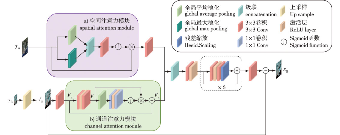
【目的】通过深度学习和图像融合技术提高Sentinel-2遥感影像的空间分辨率,增强地表信息的精确性与可靠性,为后续森林资源的精确调查和监测、农业产量预测等方面提供数据支持。【方法】提出了一种基于空间通道双流注意力的Sentinel-2遥感影像超分辨率方法,针对遥感影像多光谱与多分辨率特性设计了一种双分支模型,分别对高分辨率波段和低分辨率波段的信息进行差异化处理。其中对高分辨率波段通过引入空间注意力机制,精准捕获影像中的空间特征细节;对低分辨率波段则通过通道注意力机制动态调整光谱特征的权重分布,强化了光谱特征表达能力。在特征融合阶段,模型采用特征深度提取策略,将空间特征与光谱特征高效整合,生成包含多维度信息的复合特征表示。同时通过组合损失(即L1损失和边缘损失)实现有效地反馈学习,最终完成超分辨率重建。【结果】分别在3个地区的降级采样图像和真实图像2种数据规模下进行超分辨率重建试验,结果表明所提出的算法的客观评价指标和主观视觉效果均优于对比算法。对于降级采样图像数据,所提出的算法的均方根误差(RMSE)较Bicubic插值算法至少下降了50.33,较DSen2算法至少下降了1.64。对于真实图像数据,所提出的算法视觉效果更清晰自然。【结论】提出的基于空间通道双流注意力的遥感影像超分辨率模型能有效提高Sentinel-2遥感影像光谱的空间分辨率,为作物健康监测、土地利用分析等提供了数据支持,并扩展了Sentinel-2卫星在各个领域的应用范围。
【Objective】This study aims to enhance the spatial resolution of Sentinel-2 satellite remote sensing imagery by applying deep learning and image fusion techniques, thereby improving the accuracy and reliability of surface information extraction, so as to provide robust data support for subsequent precise investigation and monitoring of forest resources, agricultural yield prediction, and related applications.【Method】A super-resolution reconstruction method for Sentinel-2 imagery, based on a spatial-channel dual-stream attention mechanism, was proposed. Considering the inherent multi-spectral and multi-resolution characteristics of remote sensing images, a dual-branch model was designed to differentially process high-resolution (HR) and low-resolution (LR) spectral bands. The spatial attention mechanism was introduced into the HR branch to precisely capture intricate spatial details. Conversely, the channel attention mechanism was applied to the LR branch to dynamically adjust the weight distribution of spectral features, enhancing spectral feature representation. During the feature fusion stage, a deep feature extraction strategy was employed to effectively integrate spatial and spectral features, generating composite multidimensional feature representations. Additionally, a combined loss function incorporating both L1 loss and edge loss was utilized to facilitate effective feedback learning, ultimately achieving high-quality super-resolution reconstruction.【Result】Experiments were conducted on two data scales: downsampled images from three distinct regions and real Sentinel-2 images. The results demonstrated that the proposed method outperformed comparative algorithms in both objective evaluation metrics and subjective visual quality. Specifically, for the downsampled image data, the proposed method achieved a reduction in Root Mean Square Error (RMSE) of at least 50.33 compared with the bicubic interpolation method, and at least 1.64 compared to the DSen2 method. For the real image data, the proposed method yielded significantly clearer and more natural visual results.【Conclusion】The dual-stream attention model proposed in this study effectively improved the spatial resolution of Sentinel-2 satellite imagery. This enhancement can facilitate the generation of high-quality data for applications such as crop health detection and land use analysis, thereby expanding the potential utility of Sentinel-2 data across multiple domains.
 PDF(5872 KB)