PDF(17695 KB)

基于无人机多光谱与LiDAR融合的湿地松冠层水势时空动态分析
郭顺良, 牛小云, 彭叶青, 李彦杰
南京林业大学学报(自然科学版) ›› 2026, Vol. 50 ›› Issue (4) : 105-114.
PDF(17695 KB)
 PDF(17695 KB)
基于无人机多光谱与LiDAR融合的湿地松冠层水势时空动态分析
Spatiotemporal dynamics analysis of canopy water potential in Pinus elliottii using UAV-based multispectral and LiDAR fusion
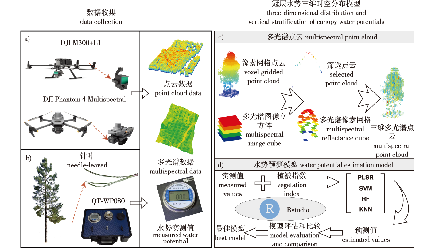
【目的】通过研究湿地松(Pinus elliottii)三维冠层水势,系统分析其年内变化,支持抗旱研究和精准林业管理。【方法】2023年12月至2024年11月,采用无人机多光谱与LiDAR融合技术,逐月采集安徽省宣城市湿地松种子园的冠层遥感数据,构建三维多光谱点云,结合随机森林(RF)模型预测水势,研究湿地松冠层水势月度和冠层垂直变化,并比较20个自由授粉家系间冠层水势的月度差异。【结果】RF模型预测精度最高(训练集R2=0.88,测试集R2=0.70)。湿地松冠层水势呈显著季节性波动,2024年3、4和7月较高,5和11月最低,垂直方向呈“上低下高”梯度。家系间冠层水势存在差异,家系1、2、14在多数月份冠层水势排序稳定居前。【结论】本研究首次实现了湿地松冠层水势的三维遥感监测,系统揭示了其时空动态变化与家系间表型差异,为抗旱研究和精准林业管理提供了新的理论依据与实践参考。
【Objective】This study investigates the three-dimensional canopy water potential of Pinus elliottii (slash pine) to systematically analyze its intra-annual variations and vertical dynamics, providing theoretical support for drought resistance research and precision forestry management.【Method】From December 2023 to November 2024, we collected monthly canopy remote sensing data in a slash pine seed orchard in Xuancheng City, Anhui Province, using the fusion technology of UAV multispectral and LiDAR data. Three-dimensional multispectral point clouds were reconstructed, and a random forest (RF) model was applied to predict canopy water potential. On this basis, we investigated the monthly dynamics and vertical canopy gradients of slash pine canopy water potential, and compared the monthly differences in canopy water potential among 20 open-pollinated families.【Result】The RF model achieved the optimal prediction accuracy, with an R2 of 0.88 for the training dataset and 0.70 for the test dataset. The canopy water potential of slash pine exhibits significant seasonal fluctuations. Higher values were observed in March, April and July 2024, while the minimum values occurred in May and November. Vertically, canopy water potential follows a vertical gradient characterized by lower values in the upper canopy and higher values in the lower canopy. Significant differences in canopy water potential were detected among families. Families 1, 2, 14 consistently ranked higher in canopy water potential across most months.【Conclusion】This study realized three-dimensional remote sensing monitoring of canopy water potential in slash pine for the first time. It systematically revealed the spatiotemporal dynamics of canopy water potential and phenotypic differences among families. The findings provide novel theoretical foundations and practical references for drought resistance research and precision forestry management.
湿地松 / 冠层水势 / 无人机遥感 / 多光谱与LiDAR融合 / 家系差异
Pinus elliottii (slash pine) / canopy water potential / UAV remote sensing / multispectral and LiDAR fusion / family divergence
| [1] |
|
| [2] |
|
| [3] |
俞满源, 黄占斌, 山仑. 不同水分条件下CO2浓度升高对植物生长及水分利用效率的影响[J]. 中国生态农业学报, 2003, 11(3):110-112.
|
| [4] |
胡继超, 姜东, 曹卫星, 等. 短期干旱对水稻叶水势、光合作用及干物质分配的影响[J]. 应用生态学报, 2004, 15(1):63-67.
|
| [5] |
贺玉晓, 赵丽, 魏雅丽, 等. 水分胁迫下柱花草叶水势、光合及叶绿素荧光特性的变化特征[J]. 农业环境科学学报, 2012, 31(10):1897-1905.
|
| [6] |
|
| [7] |
|
| [8] |
|
| [9] |
|
| [10] |
|
| [11] |
|
| [12] |
|
| [13] |
|
| [14] |
|
| [15] |
|
| [16] |
|
| [17] |
|
| [18] |
|
| [19] |
刘海娟, 张婷, 侍昊, 等. 基于RF模型的高分辨率遥感影像分类评价[J]. 南京林业大学学报(自然科学版), 2015, 39(1):99-103.
|
| [20] |
|
| [21] |
|
| [22] |
|
| [23] |
|
| [24] |
周日巍, 郭亚男, 龚伟, 等. 不同施肥量对湿地松松脂产量的影响[J]. 特种经济动植物, 2024, 27(11):43-45,74.
|
| [25] |
|
| [26] |
|
| [27] |
|
| [28] |
|
| [29] |
|
| [30] |
|
| [31] |
|
| [32] |
|
| [33] |
|
| [34] |
|
| [35] |
|
| [36] |
|
| [37] |
|
| [38] |
|
| [39] |
|
| [40] |
|
| [41] |
|
| [42] |
|
| [43] |
|
| [44] |
|
| [45] |
|
| [46] |
|
| [47] |
|
| [48] |
曾琪, 余坤勇, 姚雄, 等. 基于PROSAIL辐射传输模型的毛竹林分冠层反射率模拟研究[J]. 植物科学学报, 2017, 35(5):699-707.
|
| [49] |
姬永杰, 杨丛瑞, 张王菲, 等. 基于机载P波段全极化SAR数据的森林地上生物量估测[J]. 浙江农林大学学报, 2022, 39(5):971-980.
|
| [50] |
|
| [51] |
|
| [52] |
|
| [53] |
胡天宇, 刘小强, 吴晓永, 等. 森林冠层结构复杂性研究进展及展望[J]. 遥感学报, 2025, 29(1):83-101.
|
| [54] |
|
| [55] |
|
/
| 〈 |
|
〉 |