| [1] |
MORENO M V, CHUVIECO E. Characterising fire regimes in Spain from fire statistics[J]. Int J Wildland Fire, 2013, 22(3):296.DOI: 10.1071/wf12061.
|
| [2] |
HUSSIN Y A, MATAKALA M, ZAGDAA N. The applications of remote sensing and GIS in modeling forest fire hazard in Mongolia[J]. The International Archives of the Photogrammetry, Remote Sensing and Spatial Information Sciences, 2008(5):289-294.
|
| [3] |
GUO F T, WANG G Y, SU Z W, et al. What drives forest fire in Fujian,China? evidence from Logistic regression and Random Forests[J]. Int J Wildland Fire, 2016, 25(5):505.DOI: 10.1071/wf15121.
|
| [4] |
ESTES B L, KNAPP E E, SKINNER C N, et al. Factors influencing fire severity under moderate burning conditions in the Klamath Mountains,northern California,USA[J]. Ecosphere, 2017, 8(5):e01794.DOI: 10.1002/ecs2.1794.
|
| [5] |
ROGEAU M P, ARMSTRONG G W. Quantifying the effect of elevation and aspect on fire return intervals in the Canadian Rocky Mountains[J]. For Ecol Manag, 2017, 384:248-261.DOI: 10.1016/j.foreco.2016.10.035.
|
| [6] |
SCHILLACI C, BRAUN A, KROPÁCEK J. Terrain analysis and landform recognition[M]. Geomorphological Techniques,London: British Society for Geomorphology, 2015.
|
| [7] |
KRUEGER E S, OCHSNER T E, ENGLE D M, et al. Soil moisture affects growing-season wildfire size in the southern great plains[J]. Soil Sci Soc Am J, 2015, 79(6):1567-1576.DOI: 10.2136/sssaj2015.01.0041.
|
| [8] |
RICOTTA C, BAJOCCO S, GUGLIETTA D, et al. Assessing the influence of roads on fire ignition:does land cover matter?[J]. Fire, 2018, 1(2):24.DOI: 10.3390/fire1020024.
|
| [9] |
KALANTAR B, UEDA N, IDREES M O, et al. Forest fire susceptibility prediction based on machine learning models with resampling algorithms on remote sensing data[J]. Remote Sens, 2020, 12(22):3682.DOI: 10.3390/rs12223682.
|
| [10] |
周振伟, 于成龙. 层次分析法在森林火险预测中的应用[J]. 黑龙江气象, 2008, 25(增刊1):17-19.
|
|
ZHOU Z W, YU C L. Application of analytic hierarchy process in forest fire risk prediction[J]. Heilongjiang Meteorol, 2008, 25(S1):17-19.
|
| [11] |
许志卿, 苏喜友, 张颐. 基于支持向量机方法的森林火险预测研究[J]. 中国农学通报, 2012, 28(13):126-131.
|
|
XU Z Q, SU X Y, ZHANG Y. Forest fire prediction based on support vector machine[J]. Chin Agric Sci Bull, 2012, 28(13):126-131.DOI: 10.3969/j.issn.1000-6850.2012.13.023.
|
| [12] |
崔亮, 张继权, 包玉龙, 等. 呼伦贝尔草原火灾风险预警研究[J]. 草业学报, 2012, 21(4):282-292.
|
|
CUI L, ZHANG J Q, BAO Y L, et al. A study on early warning of grassland fire disaster risk in Hulunbeier[J]. Acta Prataculturae Sin, 2012, 21(4):282-292.DOI: 10.11686/cyxb20120434.
|
| [13] |
MALLINIS G, PETRILA M, MITSOPOULOS I, et al. Geospatial patterns and drivers of forest fire occurrence in Romania[J]. Appl Spatial Analysis, 2019, 12(4):773-795.DOI: 10.1007/s12061-018-9269-3.
|
| [14] |
高超, 林红蕾, 胡海清, 等. 我国林火发生预测模型研究进展[J]. 应用生态学报, 2020, 31(9):3227-3240.
doi: 10.13287/j.1001-9332.202009.014
|
|
GAO C, LIN H L, HU H Q, et al. A review of models of forest fire occurrence prediction in China[J]. Chin J Appl Ecol, 2020, 31(9):3227-3240.DOI: 10.13287/j.1001-9332.202009.014.
|
| [15] |
OLIVEIRA S, OEHLER F, SAN-MIGUEL-AYANZ J, et al. Modeling spatial patterns of fire occurrence in Mediterranean Europe using Multiple Regression and Random Forest[J]. For Ecol Manag, 2012, 275:117-129.DOI: 10.1016/j.foreco.2012.03.003.
|
| [16] |
贾南, 陈悦, 康可霖, 等. 基于RF的森林火灾风险评价模型及其应用研究[J]. 安全与环境学报, 2020, 20(4):1236-1240.
|
|
JIA N, CHEN Y, KANG K L, et al. Improved forest fire risk assessment model and its application based on the RF algorithm[J]. J Saf Environ, 2020, 20(4):1236-1240.DOI: 10.13637/j.issn.1009-6094.2019.0899.
|
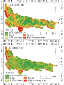
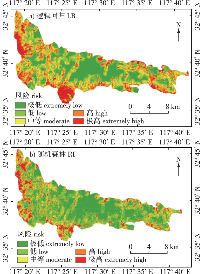
| [17] |
王雪娟, 张雪平. 韭山国家森林公园观赏植物资源及其保护与发展对策[J]. 安徽科技学院学报, 2010, 24(5):5-8.
|
|
WANG X J, ZHANG X P. Protection and development strategy of ornamental plant resources in Jiushan National Forest Park[J]. J Anhui Sci Technol Univ, 2010, 24(5):5-8.DOI: 10.3969/j.issn.1673-8772.2010.05.002.
|
| [18] |
王佳辰, 冯雨馨, 郝志尚, 等. 安徽省森林火灾预测及分析[J]. 大众标准化, 2021(13):198-200.
|
|
WANG J C, FENG Y X, HAO Z S, et al. Forecast and ana-lysis of forest fire in Anhui Province[J]. Pop Stand, 2021(13):198-200.DOI: 10.3969/j.issn.1007-1350.2021.13.067.
|
| [19] |
杨春梅, 侯玉宁, 刘九庆. 基于森林火灾数据的余火清理机器人模块化设计[J]. 森林工程, 2022, 38(2):105-111.
|
|
YANG C M, HOU Y N, LIU J Q. Modular design of embers clearing robot based on forest fire data[J]. Forest Engineering, 2022, 38(2):105-111.
|
| [20] |
MA W Y, FENG Z K, CHENG Z X, et al. Identifying forest fire driving factors and related impacts in China using random forest algorithm[J]. Forests, 2020, 11(5):507.DOI: 10.3390/f11050507.
|
| [21] |
MCDONNELL R A, LLOYD C, BURROUGH P. Principles of geographical information systems[M].3rd ed. London: Oxford University Press, 2015.
|
| [22] |
NOVO A, LORENZO H, LORENZO H, et al. Mapping forest fire risk-a case study in Galicia (Spain)[J]. Remote Sensing (Basel, Switzerland), 2020, 12(22): 3705.
|
| [23] |
SETIAWAN I, MAHMUD A R, MANSOR S, et al. GIS-grid-based and multi-criteria analysis for identifying and mapping peat swamp forest fire hazard in Pahang,Malaysia[J]. Disaster Prev And Management, 2004, 13(5):379-386.DOI: 10.1108/09653560410568507.
|
| [24] |
NIKHIL S, DANUMAH J H, SAHA S, et al. Application of GIS and AHP method in forest fire risk zone mapping:a study of the parambikulam tiger reserve,Kerala,India[J]. J Geovis Spat Anal, 2021, 5(1):14.DOI: 10.1007/s41651-021-00082-x.
|
| [25] |
EUGENIO F C, DOS SANTOS A R, FIEDLER N C, et al. Applying GIS to develop a model for forest fire risk:a case study in Espírito Santo,Brazil[J]. J Environ Manag, 2016, 173:65-71.DOI: 10.1016/j.jenvman.2016.02.021.
|
| [26] |
POURTAGHI Z S, POURGHASEMI H R, ARETANO R, et al. Investigation of general indicators influencing on forest fire and its susceptibility modeling using different data mining techniques[J]. Ecol Indic, 2016, 64:72-84.DOI: 10.1016/j.ecolind.2015.12.030.
|
| [27] |
GHESHLAGHI H A. Using GIS to develop a model for forest fire risk mapping[J]. J Indian Soc Remote Sens, 2019, 47(7):1173-1185.
doi: 10.1007/s12524-019-00981-z
|
| [28] |
ZHAO P C, ZHANG F Q, LIN H F, et al. GIS-based forest fire risk model:a case study in Laoshan National Forest Park,Nanjing[J]. Remote Sens, 2021, 13(18):3704.DOI: 10.3390/rs13183704.
|
| [19] |
DIGAVINTI J, MANIKIAM B. Satellite monitoring of forest fire impact and regeneration using NDVI and LST[J]. J Appl Rem Sens, 2021, 15(4):042412.DOI: 10.1117/1.jrs.15.042412.
|
| [30] |
GARCÍA M J L, CASELLES V. Mapping burns and natural reforestation using thematic Mapper data[J]. Geocarto Int, 1991, 6(1):31-37.DOI: 10.1080/10106049109354290.
|
| [31] |
顾先丽, 吴志伟, 张宇婧, 等. 气候变化背景下江西省林火空间预测[J]. 生态学报, 2020, 40(2):667-677.
|
|
GU X L, WU Z W, ZHANG Y J, et al. Prediction research of the forest fire in Jiangxi Province in the background of climate change[J]. Acta Ecol Sin, 2020, 40(2):667-677.DOI: 10.5846/stxb201901030022.
|
| [32] |
TIEN BUI D, LE K T, NGUYEN V, et al. Tropical forest fire susceptibility mapping at the cat Ba National Park area,Hai phong city,Vietnam,using GIS-based kernel logistic regression[J]. Remote Sens, 2016, 8(4):347.DOI: 10.3390/rs8040347.
|
| [33] |
GOLEIJI E, HOSSEINI S M, KHORASANI N, et al. Forest fire risk assessment-an integrated approach based on multicriteria evaluation[J]. Environ Monit Assess, 2017, 189(12):612.DOI: 10.1007/s10661-017-6225-7.
pmid: 29110111
|

 ), 张福全*(