
- 国家林草科技领军期刊
- 中国精品科技期刊
- 中国高校百佳科技期刊
- 江苏省新闻出版政府奖期刊奖
- RCCSE林学权威期刊(A+)
- CSCD核心期刊
- Scopus数据库收录期刊
- 中文核心期刊
- SCD核心期刊
南京林业大学学报(自然科学版) ›› 2019, Vol. 43 ›› Issue (5): 103-112.doi: 10.3969/j.issn.1000-2006.201810041
赵颖慧( ), 张大力, 甄贞*()
收稿日期:2018-10-29
修回日期:2019-04-30
出版日期:2019-10-08
发布日期:2019-10-08
基金资助:
ZHAO Yinghui(), ZHANG Dali, ZHEN Zhen*()
Received:2018-10-29
Revised:2019-04-30
Online:2019-10-08
Published:2019-10-08
摘要:
【目的】通过研究随机森林(random forest, RF)特征筛选对单木树种分类精度的影响,以及多源遥感数据协同下单木树种分类的有效性,分析不同特征对单木树种分类的影响程度。【方法】以东北林业大学帽儿山实验林场中林施业区的两块100 m×100 m样地为研究对象,首先,以机载激光雷达(LiDAR,light detection and ranging)和多光谱遥感CCD(charge coupled device)影像为数据源,分别基于机载LiDAR数据提取高度、强度和树冠大小等共37个特征,基于CCD影像提取光谱和纹理共21个特征;其次,以随机森林方法进行特征筛选,之后以随机森林和支持向量机(support vector machine, SVM)两种非参数分类器,结合不同数据源和特征,采用12种分类方案,利用总体精度(overall accuracy, OA)、用户精度(user’s accuracy, UA)和生产者精度(producer’s accuracy, PA)对分类结果进行对比与精度评价。【结果】经随机森林特征筛选后,分类结果优于未进行特征筛选的结果,总体精度可以平均提高3.47%,使用机载LiDAR和CCD影像协同分类相较于仅使用CCD影像总体精度平均提高6.07%。【结论】随机森林特征筛选可以优化特征,减少特征冗余,提高分类精度;多源数据结合也可以提高分类精度;在多源数据结合时,光谱特征最重要,LiDAR提取的强度特征相较于高度特征更稳定。
中图分类号:
赵颖慧,张大力,甄贞. 基于非参数分类算法和多源遥感数据的单木树种分类[J]. 南京林业大学学报(自然科学版), 2019, 43(5): 103-112.
ZHAO Yinghui, ZHANG Dali, ZHEN Zhen. Individual tree species classification based on nonparametric classification algorithms and multi-source remote sensing data[J].Journal of Nanjing Forestry University (Natural Science Edition), 2019, 43(5): 103-112.DOI: 10.3969/j.issn.1000-2006.201810041.
表1
两块样地统计特征"
| 统计特征 statistic feature | 样地1 plot 1 | 样地2 plot 2 | ||||||||||
|---|---|---|---|---|---|---|---|---|---|---|---|---|
| 白桦 white birch | 落叶松 larch | 红松 korean pine | 软阔 soft broadleaf | 硬阔 hard broadleaf | 红松 korean pine | 胡桃楸 walnut | 落叶松 larch | 榆树 elm | 其他 阔叶树 other broadleaf | |||
| 树高/ m tree height | 最大值max. | 23.00 | 17.70 | 22.90 | 25.80 | 20.00 | 17.30 | 21.50 | 16.70 | 19.70 | 17.10 | |
| 最小值min. | 6.10 | 7.10 | 5.20 | 6.30 | 6.70 | 5.00 | 5.10 | 5.90 | 5.10 | 5.20 | ||
| 平均值average | 12.42 | 12.19 | 10.7 | 13.61 | 14.11 | 9.36 | 11.05 | 10.69 | 9.79 | 8.71 | ||
| 标准差SD | 3.16 | 2.26 | 2.18 | 3.50 | 3.39 | 2.59 | 3.09 | 2.40 | 3.25 | 2.14 | ||
| 冠幅/ m crown width | 最大值max. | 8.16 | 5.70 | 7.55 | 12.8 | 9.72 | 10.15 | 15.6 | 7.7 | 13.4 | 9.50 | |
| 最小值min. | 1.30 | 1.06 | 1.45 | 1.88 | 2.32 | 1.56 | 1.96 | 1.85 | 1.70 | 2.00 | ||
| 平均值average | 4.00 | 2.81 | 3.54 | 5.38 | 5.55 | 3.96 | 6.09 | 3.95 | 5.72 | 4.17 | ||
| 标准差SD | 1.32 | 0.94 | 0.95 | 2.01 | 1.99 | 1.14 | 2.51 | 1.04 | 2.01 | 1.64 | ||
| 株数 number of trees | 155 | 58 | 325 | 71 | 42 | 147 | 85 | 45 | 113 | 54 | ||
图1
样地1优化前(a)后(b)和样地2优化前(c)后(d)的冠层高度模型"
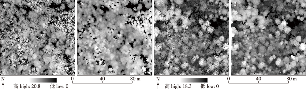
表2
地面参考数据"
| 样地1树种 tree species in plot 1 | 训练样本数 number of training sample | 验证样本数 number of validate sample | 样地2树种 tree species in plot 2 | 训练样本数 number of training sample | 验证样本数 number of validate sample |
|---|---|---|---|---|---|
| 红松korean pine | 195 | 130 | 红松korean pine | 88 | 59 |
| 落叶松larch | 34 | 24 | 胡桃楸walnut | 51 | 34 |
| 白桦white birch | 93 | 62 | 落叶松larch | 26 | 19 |
| 软阔soft broadleaf | 42 | 29 | 榆树elm | 67 | 46 |
| 硬阔hard broadleaf | 25 | 17 | 其他阔叶树other broadleaf | 31 | 23 |
| 总计 | 389 | 262 | 总计 | 263 | 181 |

图2
单木分割结果"
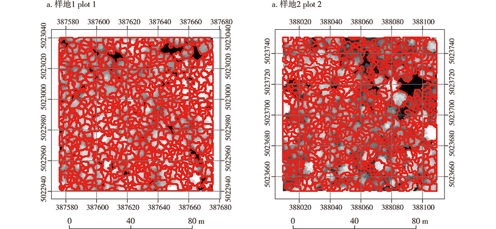
表3
特征筛选后保留特征"
| 样地 plot | 数据集 datasets | 保留特征 object features remained |
|---|---|---|
| 样地1 plot 1 | LiDAR | Hmax, Hstd, H50%; H1_st,H1_25%,H1_50%; Iave; I1_ave,I1_std,I1_var,I1_75%;Scrown |
| CCD | Rave,Rstd; Gave, Gstd; Bave, Bstd; Rrange; Grange,Gvar; Brange | |
| LiDAR + CCD | Rave,Rstd;Gave, Gstd;Bave, Bstd; Grange;H75%;Iave;I1_ave;Scrown | |
| 样地2 plot 2 | LiDAR | Hmax,Have,Hstd,H_25%,Hvar,Hcv; H1_ave,H1_25%; Iave,I75%; I1_ave,I1_75%; I1_ave,I1_75% |
| CCD | Rave,Rstd; Gave, Gstd; Bave, Bstd; Rmean; Gmean,Grange,Gskewness; Bentropy | |
| LiDAR + CCD | Rstd; Gave, Gstd; Bave, Bstd; Grange,Gskewness; Have; H1_ave; Iave; I1_ave |
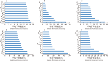
图3
经随机森林筛选后保留的特征及平均下降精度重要性排名 注:a,b,c分别为样地1中LiDAR、多光谱和多源数据保留的特征;d、e、f分别为样地2中LiDAR、多光谱和多源数据保留特征。"

表4
样地1分类结果"
| 方案 scheme | 参数 parameter | 精度/% accuarcy | Ao/% | Ka | ||||
|---|---|---|---|---|---|---|---|---|
| 白桦 white birch | 落叶松 larch | 红松 korean pine | 软阔 soft broadleaf | 硬阔 hard broadleaf | ||||
| Ⅰ | Ap | 58.62 | 34.60 | 81.68 | 45.45 | 14.29 | 62.60 | 0.43 |
| Au | 82.26 | 37.50 | 75.38 | 17.24 | 5.90 | |||
| Ⅱ | Ap | 60.47 | 40.00 | 70.39 | 100.00 | 20.00 | 64.89 | 0.44 |
| Au | 83.87 | 25.00 | 82.31 | 13.79 | 5.90 | |||
| Ⅲ | Ap | 56.82 | 37.50 | 78.57 | 50.00 | 37.50 | 64.50 | 0.47 |
| Au | 80.65 | 37.50 | 76.15 | 27.59 | 17.65 | |||
| Ⅳ | Ap | 61.18 | 41.18 | 72.00 | 100.00 | 20.00 | 66.03 | 0.46 |
| Au | 83.87 | 29.17 | 83.08 | 17.24 | 5.90 | |||
| Ⅴ | Ap | 71.23 | 50.00 | 96.06 | 37.50 | 55.56 | 77.48 | 0.66 |
| Au | 83.87 | 41.67 | 93.85 | 31.03 | 58.82 | |||
| Ⅵ | Ap | 68.66 | 42.11 | 92.59 | 30.00 | 47.83 | 74.81 | 0.62 |
| Au | 74.19 | 33.33 | 96.15 | 20.69 | 64.71 | |||
| Ⅶ | Ap | 76.92 | 51.85 | 96.06 | 47.83 | 55.00 | 79.39 | 0.69 |
| Au | 80.65 | 58.33 | 93.85 | 37.93 | 64.71 | |||
| Ⅷ | Ap | 73.91 | 53.85 | 93.13 | 50.00 | 50.00 | 78.24 | 0.69 |
| Au | 82.26 | 58.33 | 93.85 | 24.14 | 64.71 | |||
| Ⅸ | Ap | 77.03 | 57.14 | 97.73 | 66.67 | 63.64 | 84.35 | 0.76 |
| Au | 91.94 | 50.00 | 99.23 | 55.17 | 41.18 | |||
| X | Ap | 72.84 | 66.67 | 96.92 | 65.38 | 80.000 | 83.97 | 0.76 |
| Au | 95.16 | 41.67 | 96.92 | 58.62 | 47.06 | |||
| Ⅺ | Ap | 81.69 | 58.82 | 97.69 | 62.07 | 73.33 | 85.88 | 0.79 |
| Au | 93.55 | 41.67 | 97.69 | 97.69 | 64.71 | |||
| Ⅻ | Ap | 81.69 | 58.82 | 97.69 | 62.07 | 73.33 | 87.02 | 0.80 |
| Au | 93.55 | 45.83 | 100.00 | 62.07 | 64.71 | |||
表5
样地2分类结果"
| 方案 scheme | 参数 parameter | 精度/% accuracy | Ao/% | Ka | ||||
|---|---|---|---|---|---|---|---|---|
| 红松 korean pine | 胡桃楸 walnut | 落叶松 larch | 榆树 elm | 其他阔叶树 other broadleaf | ||||
| Ⅰ | Ap | 60.87 | 47.37 | 88.89 | 43.48 | 90.00 | 58.01 | 0.44 |
| Au | 71.19 | 52.94 | 84.21 | 43.48 | 39.13 | |||
| Ⅱ | Ap | 65.51 | 44.44 | 88.89 | 50.00 | 100.00 | 59.67 | 0.46 |
| Au | 79.66 | 58.82 | 84.21 | 39.13 | 30.43 | |||
| Ⅲ | Ap | 66.67 | 47.37 | 80.00 | 48.84 | 92.31 | 61.33 | 0.59 |
| Au | 81.36 | 41.18 | 84.21 | 42.65 | 52.17 | |||
| Ⅳ | Ap | 67.61 | 45.24 | 76.19 | 51.61 | 100.00 | 63.54 | 0.52 |
| Au | 81.36 | 55.88 | 84.21 | 34.00 | 69.57 | |||
| Ⅴ | Ap | 92.31 | 53.13 | 84.21 | 58.73 | 86.67 | 72.38 | 0.61 |
| Au | 81.36 | 50.00 | 84.21 | 80.43 | 56.52 | |||
| Ⅵ | Ap | 84.13 | 65.38 | 87.50 | 61.20 | 100.00 | 75.14 | 0.67 |
| Au | 89.83 | 50.00 | 73.68 | 82.61 | 60.87 | |||
| 方案 scheme | 参数 parameter | 精度/% accuracy | Ao/% | Ka | ||||
| 红松 korean pine | 胡桃楸 walnut | 落叶松 larch | 榆树 elm | 其他阔叶树 other broadleaf | ||||
| Ⅶ | Ap | 88.52 | 73.08 | 87.50 | 62.50 | 100.00 | 77.90 | 0.71 |
| Au | 91.53 | 55.88 | 73.68 | 86.70 | 60.87 | |||
| Ⅷ | Ap | 91.53 | 79.17 | 87.50 | 63.08 | 100.00 | 80.11 | 0.74 |
| Au | 91.53 | 55.88 | 73.68 | 89.13 | 73.91 | |||
| Ⅸ | Ap | 94.74 | 64.86 | 100.00 | 55.93 | 100.00 | 76.80 | 0.69 |
| Au | 91.53 | 70.59 | 84.21 | 71.74 | 52.17 | |||
| X | Ap | 94.83 | 66.67 | 100.00 | 61.40 | 100.00 | 79.11 | 0.74 |
| Au | 93.22 | 70.59 | 78.95 | 77.09 | 60.87 | |||
| Ⅺ | Ap | 94.55 | 71.43 | 94.44 | 70.21 | 88.24 | 82.32 | 0.77 |
| Au | 88.14 | 88.24 | 89.47 | 71.74 | 65.22 | |||
| Ⅻ | Ap | 96.43 | 72.50 | 100.00 | 74.51 | 100.00 | 84.53 | 0.80 |
| Au | 91.53 | 85.29 | 94.74 | 82.61 | 73.68 | |||
| [1] | 刘旭升, 张晓丽. 森林植被遥感分类研究进展与对策[J]. 林业资源管理, 2004(1):61-64. DOI: 10.3969/j.issn.1002-6622.2004.01.016. |
| LIU X S, ZHANG X L. Research advances and countermeasures of remote sensing classification of forest vegetation[J]. Forest Resources Management, 2004(1):61-64. | |
| [2] |
WULDER M A, HALL R J, COOPS N C, et al. High spatial resolution remotely sensed data for ecosystem characterization[J]. BioScience, 2004, 54(6):511-521. DOI: 10.1641/0006-3568(2004)054[0511:hsrrsd]2.0.co;2.
doi: 10.1641/0006-3568(2004)054[0511:HSRRSD]2.0.CO;2 |
| [3] | VAUHKONEN J, MALTAMO M, MCROBERTS R E, et al. Introduction to forestry applications of airborne laser scanning [C]// VAUHKONEN J, MALTAMO M, MCROBERTS R E, et al. Forestry Applications of Airborne Laser Scanning. Dordrecht: Springer Netherlands, 2013: 1-16. DOI: 10.1007/978-94-017-8663-8_1. |
| [4] |
ZHANG Z Y, LIU X Y. Support vector machines for tree species identification using LiDAR-derived structure and intensity variables[J]. Geocarto International, 2013, 28(4):364-378. DOI: 10.1080/10106049.2012.710653.
doi: 10.1080/10106049.2012.710653 |
| [5] |
SWATANTRAN A, DUBAYAH R, ROBERTS D, et al. Mapping biomass and stress in the Sierra Nevada using lidar and hyperspectral data fusion[J]. Remote Sensing of Environment, 2011, 115(11):2917-2930. DOI: 10.1016/j.rse.2010.08.027.
doi: 10.1016/j.rse.2010.08.027 |
| [6] | 李春干, 邵国凡. Landsat 7 ETM+图像用作SPOT5图像森林分类的辅助数据研究[J]. 北京林业大学学报, 2010, 32(4):1-5. |
| LI C G, SHAO G F. Using Landsat 7 ETM+ images as ancillary data for forest cover classification of SPOT5 images[J]. Journal of Beijing Forestry University, 2010, 32(4):1-5. | |
| [7] | 魏晶昱, 毛学刚, 方本煜, 等. 基于Landsat 8 OLI辅助的亚米级遥感影像树种识别[J]. 北京林业大学学报, 2016, 38(11):23-33. DOI: 10.13332/j.1000-1522.20160054. |
| WEI J Y, MAO X G, FANG B Y, et al. Submeter remote sensing image recognition of trees based on Landsat 8 OLI support[J]. Journal of Beijing Forestry University, 2016, 38(11):23-33. | |
| [8] |
HAN N, WANG K, YU L, et al. Integration of texture and landscape features into object-based classification for delineating Torreya using IKONOS imagery[J]. International Journal of Remote Sensing, 2012, 33(7):2003-2033. DOI: 10.1080/01431161.2011.605084.
doi: 10.1080/01431161.2011.605084 |
| [9] |
BLASCHKE T. Object based image analysis for remote sensing[J]. ISPRS Journal of Photogrammetry and Remote Sensing, 2010, 65(1):2-16. DOI: 10.1016/j.isprsjprs.2009.06.004.
doi: 10.1016/j.isprsjprs.2009.06.004 |
| [10] |
KE Y H, QUACKENBUSH L J, IM J. Synergistic use of QuickBird multispectral imagery and LIDAR data for object-based forest species classification[J]. Remote Sensing of Environment, 2010, 114(6):1141-1154. DOI: 10.1016/j.rse.2010.01.002.
doi: 10.1016/j.rse.2010.01.002 |
| [11] |
OLOFSSON K, WALLERMAN J, HOLMGREN J, et al. Tree species discrimination using Z/I DMC imagery and template matching of single trees[J]. Scandinavian Journal of Forest Research, 2006, 21(S7):106-110. DOI: 10.1080/14004080500486955.
doi: 10.1080/14004080500486955 |
| [12] |
BUNTING P, LUCAS R. The delineation of tree crowns in Australian mixed species forests using hyperspectral compact airborne spectrographic imager (CASI) data[J]. Remote Sensing of Environment, 2006, 101(2):230-248. DOI: 10.1016/j.rse.2005.12.015.
doi: 10.1016/j.rse.2005.12.015 |
| [13] |
ZHEN Z, QUACKENBUSH L, ZHANG L J. Impact of tree-oriented growth order in marker-controlled region growing for individual tree crown delineation using airborne laser scanner (ALS) data[J]. Remote Sensing, 2014, 6(1):555-579. DOI: 10.3390/rs6010555.
doi: 10.3390/rs6010555 |
| [14] | CHEN Q, BALDOCCHI D, GONG P, et al. Isolating individual trees in a savanna woodland using small footprint lidar data[J]. Photogrammetric Engineering & Remote Sensing, 2006, 72(8):923-932. DOI: 10.14358/pers.72.8.923. |
| [15] |
ZHAO Y H, HAO Y S, ZHEN Z, et al. A region-based hierarchical cross-section analysis for individual tree crown delineation using ALS data[J]. Remote Sensing, 2017, 9(10):1084. DOI: 10.3390/rs9101084.
doi: 10.3390/rs9101084 |
| [16] |
DALPONTE M, BRUZZONE L, VESCOVO L, et al. The role of spectral resolution and classifier complexity in the analysis of hyperspectral images of forest areas[J]. Remote Sensing of Environment, 2009, 113(11):2345-2355. DOI: 10.1016/j.rse.2009.06.013.
doi: 10.1016/j.rse.2009.06.013 |
| [17] |
PANG Y, LI Z Y, JU H B, et al. LiCHy: the CAF’s LiDAR, CCD and hyperspectral integrated airborne observation system[J]. Remote Sensing, 2016, 8(5):398. DOI: 10.3390/rs8050398.
doi: 10.3390/rs8050398 |
| [18] |
ZHAO D, PANG Y, LI Z Y, et al. Filling invalid values in a lidar-derived canopy height model with morphological crown control[J]. International Journal of Remote Sensing, 2013, 34(13):4636-4654. DOI: 10.1080/01431161.2013.779398.
doi: 10.1080/01431161.2013.779398 |
| [19] | KHOSRAVIPOUR A, SKIDMORE A K, ISENBURG M, et al. Generating pit-free canopy height models from airborne lidar[J]. Photogrammetric Engineering & Remote Sensing, 2014, 80(9):863-872. DOI: 10.14358/pers.80.9.863. |
| [20] |
ANDERSEN H E, MCGAUGHEY R J, REUTEBUCH S E. Estimating forest canopy fuel parameters using LIDAR data[J]. Remote Sensing of Environment, 2005, 94(4):441-449. DOI: 10.1016/j.rse.2004.10.013.
doi: 10.1016/j.rse.2004.10.013 |
| [21] |
LIN Y, HYYPPÄ J. A comprehensive but efficient framework of proposing and validating feature parameters from airborne LiDAR data for tree species classification[J]. International Journal of Applied Earth Observation and Geoinformation, 2016, 46:45-55. DOI: 10.1016/j.jag.2015.11.010
doi: 10.1016/j.jag.2015.11.010 |
| [22] |
YAO W, KRZYSTEK P, HEURICH M. Tree species classification and estimation of stem volume and DBH based on single tree extraction by exploiting airborne full-waveform LiDAR data[J]. Remote Sensing of Environment, 2012, 123:368-380. DOI: 10.1016/j.rse.2012.03.027.
doi: 10.1016/j.rse.2012.03.027 |
| [23] |
SHI Y F, WANG T J, SKIDMORE A K, et al. Important LiDAR metrics for discriminating forest tree species in Central Europe[J]. ISPRS Journal of Photogrammetry and Remote Sensing, 2018, 137:163-174. DOI: 10.1016/j.isprsjprs.2018.02.002.
doi: 10.1016/j.isprsjprs.2018.02.002 |
| [24] |
ZHANG C Q, FRANKLIN S E, WULDER M A. Geostatistical and texture analysis of airborne-acquired images used in forest classification[J]. International Journal of Remote Sensing, 2004, 25(4):859-865. DOI: 10.1080/01431160310001618059.
doi: 10.1080/01431160310001618059 |
| [25] |
PAL M, FOODY G M. Feature selection for classification of hyperspectral data by SVM[J]. IEEE Transactions on Geoscience and Remote Sensing, 2010, 48(5):2297-2307. DOI: 10.1109/tgrs.2009.2039484.
doi: 10.1109/TGRS.2009.2039484 |
| [26] | 季金胜. 高分辨率遥感影像典型地物目标的特征选择及其稳定性研究[D]. 上海: 上海交通大学, 2015. |
| JI J S. Feature selection and its stability for typical geoobjects of the high-resolution remote sensing image[D]. Shanghai: Shanghai Jiaotong University, 2015. | |
| [27] |
BAKSHI B R. Multiscale PCA with application to multivariate statistical process monitoring[J]. AIChE Journal, 1998, 44(7):1596-1610. DOI: 10.1002/aic.690440712.
doi: 10.1002/(ISSN)1547-5905 |
| [28] |
HASSANAT A B A, ESRA’N A, ALKAFAWEEN A. On enhancing genetic algorithms using new crossovers[J]. International Journal of Computer Applications in Technology, 2017, 55(3):202. DOI: 10.1504/ijcat.2017.084774.
doi: 10.1504/IJCAT.2017.084774 |
| [29] |
ARCHER K J, KIMES R V. Empirical characterization of random forest variable importance measures[J]. Computational Statistics & Data Analysis, 2008, 52(4):2249-2260. DOI: 10.1016/j.csda.2007.08.015.
doi: 10.1016/j.csda.2007.08.015 |
| [30] | ADELE C, RICHARD C, JOHN R S. Random forests[J]. Machine Learning, 2004, 45(1):157-176. DOI: 10.1007/978-1-4419-9326-7_5. |
| [31] |
BELGIU M, DRAGUŢ L. Random forest in remote sensing: a review of applications and future directions[J]. ISPRS Journal of Photogrammetry and Remote Sensing, 2016, 114:24-31. DOI: 10.1016/j.isprsjprs.2016.01.011
doi: 10.1016/j.isprsjprs.2016.01.011 |
| [32] |
MOUNTRAKISM J, OGOLE C. Support vector machines in remote sensing: a review[J]. ISPRS Journal of Photogrammetry and Remote Sensing, 2011, 66(3):247-259. DOI: 10.1016/j.isprsjprs.2010.11.001.
doi: 10.1016/j.isprsjprs.2010.11.001 |
| [33] |
HUANG C L, WANG C J. A GA-based feature selection and parameters optimization for support vector machines[J]. Expert Systems with Applications, 2006, 31(2):231-240.DOI: 10.1016/j.eswa.2005.09.024.
doi: 10.1016/j.eswa.2005.09.024 |
| [34] | 李星祥. 超高维数据的特征筛选研究[D]. 南京: 南京信息工程大学, 2016. |
| LI X X. Study on ultrahigh dimensional feature screening[D]. Nanjing: Nanjing University of Information Science & Technology, 2016. | |
| [35] |
PHAM L T H, BRABYN L, ASHRAF S. Combining QuickBird, LiDAR, and GIS topography indices to identify a single native tree species in a complex landscape using an object-based classification approach[J]. International Journal of Applied Earth Observation and Geoinformation, 2016, 50:187-197. DOI: 10.1016/j.jag.2016.03.015.
doi: 10.1016/j.jag.2016.03.015 |
| [36] |
ADELABU S, DUBE T. Employing ground and satellite-based QuickBird data and random forest to discriminate five tree species in a Southern African Woodland[J]. Geocarto International, 2015, 30(4):457-471. DOI: 10.1080/10106049.2014.885589.
doi: 10.1080/10106049.2014.885589 |
| [37] |
HOVI A, KORHONEN L, VAUHKONEN J, et al. LiDAR waveform features for tree species classification and their sensitivity to tree-and acquisition related parameters[J]. Remote Sensing of Environment, 2016, 173:224-237. DOI: 10.1016/j.rse.2015.08.019.
doi: 10.1016/j.rse.2015.08.019 |
| [38] |
SUMNALL M J, HILL R A, HINSLEY S A. Comparison of small-footprint discrete return and full waveform airborne lidar data for estimating multiple forest variables[J]. Remote Sensing of Environment, 2016, 173:214-223. DOI: 10.1016/j.rse.2015.07.027.
doi: 10.1016/j.rse.2015.07.027 |
| [39] |
ØRKA H O, NÆSSET E, BOLLANDSÅS O M. Effects of different sensors and leaf-on and leaf-off canopy conditions on echo distributions and individual tree properties derived from airborne laser scanning[J]. Remote Sensing of Environment, 2010, 114(7):1445-1461. DOI: 10.1016/j.rse.2010.01.024.
doi: 10.1016/j.rse.2010.01.024 |
| [40] |
KORPELA I, HOVI A, KORHONEN L. Backscattering of individual LiDAR pulses from forest canopies explained by photogrammetrically derived vegetation structure[J]. ISPRS Journal of Photogrammetry and Remote Sensing, 2013, 83:81-93. DOI: 10.1016/j.isprsjprs.2013.06.002.
doi: 10.1016/j.isprsjprs.2013.06.002 |
| [41] |
DENG S Q, KATOH M, YU X W, et al. Comparison of tree species classifications at the individual tree level by combining ALS data and RGB images using different algorithms[J]. Remote Sensing, 2016, 8(12):1034. DOI: 10.3390/rs8121034.
doi: 10.3390/rs8121034 |
| [42] |
HOLMGREN J, PERSSON Å. Identifying species of individual trees using airborne laser scanner[J]. Remote Sensing of Environment, 2004, 90(4):415-423. DOI: 10.1016/s0034-4257(03)00140-8.
doi: 10.1016/S0034-4257(03)00140-8 |
| [43] | 刘丽娟, 庞勇, 范文义, 等. 机载LiDAR和高光谱融合实现温带天然林树种识别[J]. 遥感学报, 2013, 17(3):679-695. |
| LIU L J, PANG Y, FAN W Y, et al. Fused airborne LiDAR and hyperspectral data for tree species identification in a natural temperate forest[J]. Journal of Remote Sensing, 2013, 17(3):679-695. | |
| [44] |
DALPONTE M, ØRKA H O, ENE L T, et al. Tree crown delineation and tree species classification in boreal forests using hyperspectral and ALS data[J]. Remote Sensing of Environment, 2014, 140:306-317. DOI: 10.1016/j.rse.2013.09.006.
doi: 10.1016/j.rse.2013.09.006 |
| [1] | 孔得伦, 邢艳秋. GEDI与ICESat-2星载激光雷达数据反演树高研究[J]. 南京林业大学学报(自然科学版), 2025, 49(2): 175-184. |
| [2] | 严宇, 李秋洁, 李卫正. 面向侧视MLS点云的行道树单木分割方法[J]. 南京林业大学学报(自然科学版), 2024, 48(6): 166-174. |
| [3] | 钟浩, 王楚虹, 林文树. 联合地基激光雷达与无人机影像的树种识别[J]. 南京林业大学学报(自然科学版), 2024, 48(4): 104-112. |
| [4] | 潘政尚, 马开森, 龙依, 赖珍贵, 孙华. 改进分类回归树模型的青冈枝叶点云分类研究[J]. 南京林业大学学报(自然科学版), 2024, 48(4): 123-131. |
| [5] | 严宇, 李秋洁. 行道树靶标点云在线分割方法[J]. 南京林业大学学报(自然科学版), 2024, 48(4): 141-149. |
| [6] | 周友锋, 谢秉楼, 李明诗. 基于随机森林协同克里金法的区域森林地上生物量制图——以粤北森林为例[J]. 南京林业大学学报(自然科学版), 2024, 48(1): 169-178. |
| [7] | 高谢雨, 董利虎, 郝元朔. 基于TLS的抚育间伐对长白落叶松干形的影响[J]. 南京林业大学学报(自然科学版), 2023, 47(6): 85-94. |
| [8] | 黄靖舒, 高心丹, 景维鹏. 基于BOVW和SVM的城市土地类型遥感变化监测研究[J]. 南京林业大学学报(自然科学版), 2023, 47(3): 37-44. |
| [9] | 唐依人, 贾炜玮, 王帆, 孙毓蔓, 张颖. 基于TLS辅助的长白落叶松一级枝条生物量模型构建[J]. 南京林业大学学报(自然科学版), 2023, 47(2): 130-140. |
| [10] | 董瀚元, 于颖, 范文义. 星载激光雷达GEDI数据林下地形反演性能验证[J]. 南京林业大学学报(自然科学版), 2023, 47(2): 141-149. |
| [11] | 王帆, 贾炜玮, 唐依人, 李丹丹. 基于TLS的红松树冠半径提取及其外轮廓模型构建[J]. 南京林业大学学报(自然科学版), 2023, 47(1): 13-22. |
| [12] | 孙铭辰, 姜立春. 基于机器学习算法的樟子松立木材积预测[J]. 南京林业大学学报(自然科学版), 2023, 47(1): 31-37. |
| [13] | 王甜, 王雪峰, 刘嘉政. 基于RFE_RF算法的幼龄沉香叶片含水率预估模型[J]. 南京林业大学学报(自然科学版), 2022, 46(4): 177-184. |
| [14] | 吴炅, 蒋馥根, 彭邵锋, 马开森, 陈松, 孙华. 结合树冠体积的油茶树高与产量估测研究[J]. 南京林业大学学报(自然科学版), 2022, 46(2): 53-62. |
| [15] | 巨一琳, 姬永杰, 黄继茂, 张王菲. 联合LiDAR和多光谱数据森林地上生物量反演研究[J]. 南京林业大学学报(自然科学版), 2022, 46(1): 58-68. |
| 阅读次数 | ||||||
|
全文 |
|
|||||
|
摘要 |
|
|||||

