
- 国家林草科技领军期刊
- 中国精品科技期刊
- 中国高校百佳科技期刊
- 江苏省新闻出版政府奖期刊奖
- RCCSE林学权威期刊(A+)
- CSCD核心期刊
- Scopus数据库收录期刊
- 中文核心期刊
- SCD核心期刊
南京林业大学学报(自然科学版) ›› 2020, Vol. 44 ›› Issue (5): 9-16.doi: 10.3969/j.issn.1000-2006.202004044
所属专题: 园林文化遗产研究专题
梁慧琳( ), 张青萍*()
收稿日期:2020-04-22
修回日期:2020-05-26
出版日期:2020-10-30
发布日期:2020-10-30
基金资助:
LIANG Huilin(), ZHANG Qingping*()
Received:2020-04-22
Revised:2020-05-26
Online:2020-10-30
Published:2020-10-30
摘要:
为了解三维数字化测绘和信息管理技术应用于园林文化遗产对象的研究进展,通过梳理三维数字化测绘和信息技术应用于园林文化遗产及其相关对象的中、英文文献,从近景摄影测量、三维激光扫描和多技术综合测绘等三维数字化测绘技术与三维地理信息系统和信息模型等三维信息管理技术等方面,分析了三维数字化测绘和信息管理技术应用于园林文化遗产对象的技术特点、应用情况和相关案例。笔者认为,文化遗产保护工作至关重要,三维数字化测绘和信息技术的应用在古建筑、古遗址等对象上收获颇丰,园林文化遗产研究成果相对较少,但足以证明其应用具优势,且将成为必然趋势。三维数字化测绘方法上,近景摄影测量和三维激光扫描技术各有千秋,利用多传感器的综合测绘方法能够克服单一技术和仪器的局限,是园林文化遗产数据获取的理想方法;三维信息管理方法上,三维地理信息系统的应用和园林信息模型等概念将成为园林文化遗产信息管理的研究热点。园林文化遗产保护,乃至风景园林学科,将向基于三维数字化、信息化技术的方向发展。利用现代三维数字化测绘和信息技术进行数据采集、处理、储存和信息管理、维护、更新、分析,对园林文化遗产的保护、研究和可持续利用具有重大的历史和现实意义。
中图分类号:
梁慧琳,张青萍. 园林文化遗产三维数字化测绘与信息管理研究进展[J]. 南京林业大学学报(自然科学版), 2020, 44(5): 9-16.
LIANG Huilin, ZHANG Qingping. A review of three-dimensional digital surveying and information management for garden cultural heritages[J].Journal of Nanjing Forestry University (Natural Science Edition), 2020, 44(5): 9-16.DOI: 10.3969/j.issn.1000-2006.202004044.
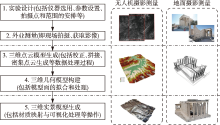
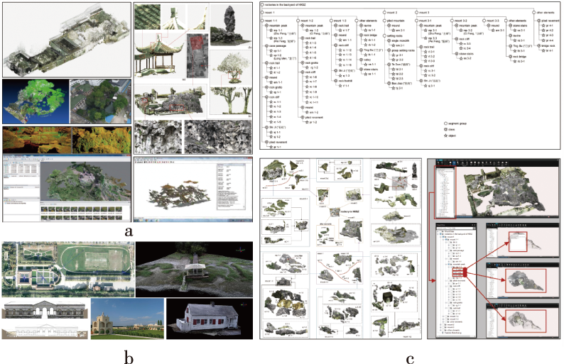
图1
近景摄影测量一般流程[4]"
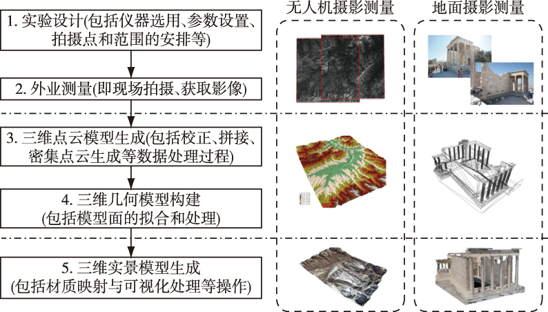
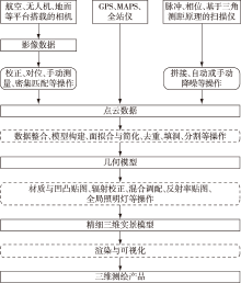
图2
多技术综合测绘工作流程[4]"
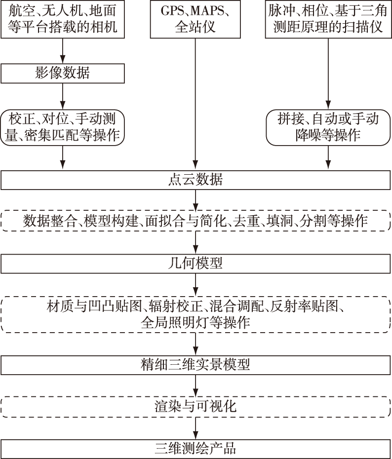
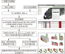
图3
HBIM一般工作流程[25,26,27]"
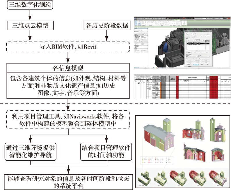
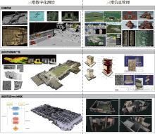
图4
古城遗址案例[4, 8, 13, 32, 35, 40, 43-46]"

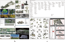
图5
中国古典园林(a)、西方古典园林(b)三维数字化测绘及中国古典园林三维信息管理(c)"
| [1] |
SOLER F, MELERO F J, LUZÓN M V . A complete 3D information system for cultural heritage documentation[J]. J Cult Herit, 2017,23:49-57. DOI: 10.1016/j.culher.2016.09.008.
doi: 10.1016/j.culher.2016.09.008 |
| [2] |
DENG Y C, CHENG J C P, ANUMBA C . Mapping between BIM and 3D GIS in different levels of detail using Schema mediation and instance comparison[J]. Autom Constr, 2016,67:1-21. DOI: 10.1016/j.autcon.2016.03.006.
doi: 10.1016/j.autcon.2016.03.006 |
| [3] | 张勃 . 以三维数字技术推动中国传统园林掇山理法研究[J]. 古建园林技术, 2010(2):36-38. |
| ZHANG B . Research on the implementation of 3D digital technology in the traditional rockery skill of Chinese garden[J]. Tradit Chin Archit Gard, 2010(2):36-38. | |
| [4] |
REMONDINO F, RIZZI A . Reality-based 3D documentation of natural and cultural heritage sites:techniques,problems, and examples[J]. Appl Geomat, 2010,2(3):85-100. DOI: 10.1007/s12518-010-0025-x.
doi: 10.1007/s12518-010-0025-x |
| [5] |
CHANDLER J H, BRYAN P, FRYER J G . The development and application of a simple methodology for recording rock art using consumer-grade digital cameras[J]. Photogramm Rec, 2007,22(117):10-21. DOI: 10.1111/j.1477-9730.2007.00414.x.
doi: 10.1111/phor.2007.22.issue-117 |
| [6] | BRYAN P, BLAKE B, BEDFORD J. Metric survey specifications for cultural heritage[M]. London : English Heritage Publishing, 2013. |
| [7] | GUIDI G, REMONDINO F, RUSSO M , et al. Range sensors on marble surfaces:quantitative evaluation of artifacts [C]// FABIO R,SHORTIS M R,SABRY F E.SPIE 7447,Videometrics,Range Imaging,and Applications X.San Diego,California,USA, 2009,7447:744703. |
| [8] | REMONDINO F, GRUEN A, VON SCHWERIN J , et al. Multi-sensor 3D documentation of the Maya site of Copán [C]// Proceedings of the Proceedings of 22nd CIPA Symposium.Kyoto, Japan, 2009. |
| [9] | REMONDINO F. Accurate and detailed image-based 3D documentation of large sites and complex objects[C]//Digital imaging for cultural heritage preservation. London: CRC Press, 2017: 127-157. DOI: 10.1201/b11049-5. |
| [10] |
GUIDI G, RUSSO M, ERCOLI S , et al. A multi-resolution methodology for the 3D modeling of large and complex archeological areas[J]. Int J Archit Comput, 2009,7(1):39-55. DOI: 10.1260/147807709788549439.
doi: 10.1260/147807709788549439 |
| [11] |
LERMA J L, NAVARRO S, CABRELLES M , et al. Terrestrial laser scanning and close range photogrammetry for 3D archaeological documentation:the Upper Palaeolithic Cave of Parpalló as a case study[J]. J Archaeol Sci, 2010,37(3):499-507. DOI: 10.1016/j.jas.2009.10.011.
doi: 10.1016/j.jas.2009.10.011 |
| [12] | KEINAN. Israeli and Palestinian archaeological inventories, GIS and conflicting cultures in the occupiedWest Bank[D]. London:University College London, 2013. |
| [13] | DELL’UNTO N, LANDESCHI G, LEANDER TOUATI A M , et al. Experiencing ancient buildings from a 3D GIS perspective:a case drawn from the Swedish Pompeii project[J]. J Archaeol Method Theory, 2016,23(1):73-94. DOI: 10.1007/s10816-014-9226-7. |
| [14] | CANCIANI M, CENICCOLA V, MESSI M , et al. A 3D GIS method applied to cataloging and restoring:the case of Aurelian walls at Rome[J]. Int Arch Photogramm Remote Sens Spatial Inf Sci, 2013, XL-5/W2:143-148. DOI: 10.5194/isprsarchives-xl-5-w2-143-2013. |
| [15] | SAYGI G, AGUGIARO G, HAMAMCıOGLU-TURAN M , et al. Evaluation of GIS and BIM roles for the information management of historical buildings[J]. ISPRS Ann Photogramm Remote Sens Spatial Inf Sci, 2013, II-5/W1:283-288. DOI: 10.5194/isprsannals-ii-5-w1-283-2013. |
| [16] | MATHIEU K, CAMILLE L. De la maquette 3D au SIG 3D pour la gestion du patrimoine archéologique [R]. SIG 2008.[2020-02-12]. http://www.geomag.fr/sites/default/files/64_78.pdf. |
| [17] | CONOLLY J, LAKE M. Geographical information systems in archaeology[M]. Cambridge: Cambridge University Press, 2006. |
| [18] | FIORINI A, URCIA A, ARCHETTI V . The digital 3D survey as standard documentation of the archaeological stratigraphy [C]//VAST’11:Proceedings of the 12th International Conference on Virtual Reality.Archaeology and Cultural Heritage, 2011: 145-152. |
| [19] | BRUNETAUD X, DE LUCA L, JANVIER-BADOSA S , et al. Application of digital techniques in monument preservation[J]. Eur J Environ Civ Eng, 2012,16(5):543-556. DOI: 10.1080/19648189.2012.676365. |
| [20] | JANVIER-BADOSA S, STEFANI C, BRUNETAUD X , et al. Documentation and analysis of 3D mappings for monument diagnosys[M]//Built Heritage: Monitoring Conservation Management. Cham: Springer International Publishing, 2014: 347-357. DOI: 10.1007/978-3-319-08533-3_29. |
| [21] | STEFANI C, BRUNETAUD X, JANVIER-BADOSA S , et al. Developing a toolkit for mapping and displaying stone alteration on a web-based documentation platform[J]. J Cult Herit, 2014,15(1):1-9. DOI: 10.1016/j.culher.2013.01.011. |
| [22] | CAMPANARO D M, LANDESCHI G, DELL’UNTO N , et al. 3D GIS for cultural heritage restoration:a ‘White Box’ workflow[J]. J Cult Herit, 2016,18:321-332. DOI: 10.1016/j.culher.2015.09.006. |
| [23] | PATRICK SUERMANN . Evaluating the impact of building information modeling on construction[D]. Texas :Texas A & M University, 2009. |
| [24] | 代婷婷, 马骏, 徐雁南 . 基于Agisoft PhotoScan 的无人机影像自动拼接在风景园林规划中的应用[J]. 南京林业大学学报(自然科学版), 2018,42(4):165-170. |
| DAI T T, MA J, XU Y N . Application of unmanned aerial vehicle(UAV)image automatic stitchingin landscape planning based on Agisoft PhotoScan[J]. J Nanjing For Univ (Nat Sci Ed), 2018,42(4):165-170. DOI: 10.3969/j.issn.1000-2006.201707004. | |
| [25] | FAI S, GRAHAM K, DUCKWORTH T , et al. Building information modelling and heritage documentation [C]// Proceedings of the 23rd International Symposium, International Scientific Committee for Documentation of Cultural Heritage (CIPA). Prague:Czech Republic F, 2011: 12-16. |
| [26] | ORENI D, BRUMANA R, DELLA TORRE S , et al. Survey turned into HBIM:the restoration and the work involved concerning the Basilica di Collemaggio after the earthquake (L’Aquila)[J]. ISPRS Ann Photogramm Remote Sens Spatial Inf Sci, 2014, II-5:267-273. DOI: 10.5194/isprsannals-ii-5-267-2014. |
| [27] | BRUMANA R, ORENI D, RAIMONDI A , et al. From survey to HBIM for documentation,dissemination and management of built heritage:The case study of St.Maria in Scaria d’Intelvi [C]//2013 Digital Heritage International Congress (DigitalHeritage).28 Oct.-1 Nov.2013,Marseille,France: IEEE, 2013: 497-504. DOI: 10.1109/DigitalHeritage.2013.6743789. |
| [28] | GILL L . A 3D landscape information model[D]. Sheffield :University of Sheffield, 2013. |
| [29] | AHMAD A M, ALIYU A A . The need for landscape information modelling (LIM) in landscape architecture [C]//Proceedings of the 13th Digital Landscape Architecture Conference.Germany F, 2012: 531-540. |
| [30] | STOUFFS R, SARIYILDIZ S . Computation & performance:proceedings of the 31st international conference on education and research in computer aided architectural design in Europe[M/OL]. Delft: eCAADe, 2013.[2020-02-12]. http:ecaade 2013.bk.tudelft.nl/. |
| [31] | ERVIN S M . Digital landscape modeling and visualization:a research agenda[J]. Landsc Urban Plan, 2001,54(1/2/3/4):49-62. DOI: 10.1016/s0169-2046(01)00125-6. |
| [32] | 梁慧琳 . 苏州环秀山庄园林三维数字化信息研究[D]. 南京:南京林业大学, 2018. |
| LIANG H L . Three-dimensional digital information research for the garden of Huanxiu Shanzhuang,Suzhou,China[D]. Nanjing:Nanjing Forestry University, 2018. | |
| [33] | 赖文波, 杜春兰, 贾铠针 , 等. 景观信息模型(LIM)框架构建研究:以重庆大学B校区三角地改造为例[J]. 中国园林, 2015,31(7):26-30. |
| LAI W B, DU C L, JIA K Z , et al. Research on the framework construction of landscape information modeling(LIM):taking the transformation of the triangular site in Chongqing University campus B as an example[J]. Chin Landsc Archit, 2015,31(7):26-30. | |
| [34] | 杨晨 . 遗产景观信息模型初探[C]// 中国风景园林学会. 中国风景园林学会2016年会论文集. 北京: 中国风景园林学会, 2016: 419-423. |
| [35] | SCHWERIN J V, RICHARDS-RISSETTO H, REMONDINO F , et al. The Maya Arch3D project:digital technologies for research in Maya archaeology[EB/OL]. 2010.[2020-02-12]. https://www.researchgate.net/publication/265427443. |
| [36] | MACA A L . Spatio-temporal boundaries in classic Maya settlement systems:Copan’s urban foothills and the excavations at Group 9J-5 (Honduras)[D]. Boston:Harvard University, 2002. |
| [37] | RICHARDS-RISSETTO H . Exploring social interaction at the ancient Maya City of Copán,Honduras:a multi-scalar geographic information systems (GIS) analysis of access and visibility[D]. Lincoln :University of Nebraska, 2010. |
| [38] | AGUGIARO G, REMONDINO F, GIRARDI G , et al. Queryarch3d:querying and visualising 3D models of a Maya archaeological site in a web-based interface[J]. Geoinformatics FCE CTU, 2011,6:10-17. DOI: 10.14311/gi.6.2. |
| [39] | AGUGIARO G, REMONDINO F, GIRARDI G , et al. A web-based interactive tool for multi-resolution 3D models of a Maya archaeological site[J]. Isprs International Archives of the Photogrammetry, 2012,16:23-30. DOI: 10.5194/isprsarchives-xxxviii-5-w16-23-2011. |
| [40] | VON SCHWERIN J, RICHARDS-RISSETTO H, REMONDINO F , et al. The MayaArch3D project:a 3D WebGIS for analyzing ancient architecture and landscapes[J]. Lit Linguist Computing, 2013,28(4):736-753. DOI: 10.1093/llc/fqt059. |
| [41] | RICHARDS-RISSETTO H, ROBERTSSON J, VON SCHWERIN J , et al. Geospatial virtual heritage:a gesture-based 3D GIS to engage the public with ancient Maya archaeology[M]//VERHAGEN P, EARL G. Archaeology in the Digital Era. Amsterdam: Amsterdam University Press, 2014: 118-130. |
| [42] | A Y H, A O A, A A H . Laser scanning in Pompeian City wall a comparative study of accuracy of the drawings from 1930s to 40s[EB/OL]. 2012.[2020-02-12]. https://www.researchgatenet/.publication/267769393. |
| [43] | MANFERDINI A M, REMONDINO F, BALDISSINI S , et al. 3D modeling and semantic classification of archaeological finds for management and visualization in 3D archaeological databases[EB/OL].[ 2020- 02- 12]. http://pdfs.semanticscholar.org/3506/00928b581161d8b83e1ad78ef8917866c936.pdf. |
| [44] | DELL’UNTO N, LEANDER A M, DELLEPIANE M , et al. Digital reconstruction and visualization in archaeology: case-study drawn from the work of the Swedish Pompeii Project [C]//2013 Digital Heritage International Congress (DigitalHeritage).28 Oct.-1 Nov.2013,Marseille,France.IEEE, 2013: 621-628. DOI: 10.1109/DigitalHeritage.2013.6743804. |
| [45] | LANDESCHI G, DELL’UNTO N, LUNDQVIST K , et al. 3D-GIS as a platform for visual analysis:investigating a Pompeian house[J]. J Archaeol Sci, 2016,65:103-113. DOI: 10.1016/j.jas.2015.11.002. |
| [46] | REMONDINO F, EL-HAKIM S, GRUEN A , et al. Development and performance analysis of image matching for detailed surface reconstruction of heritage objects[J/OL]. IEEE Signal Processing Magazine, 2008: 55-64. [2020-02-12]. https://www.researchgate.net/publication/292757823_Development_and_performance_analysis_of_image_matching_for_detailed_surface_reconstruction_of_heritage_objects. |
| [47] | 张青萍, 梁慧琳, 李卫正 , 等. 数字化测绘技术在私家园林中的应用研究[J]. 南京林业大学学报(自然科学版), 2018,42(1):1-6. |
| ZHANG Q P, LIANG H L, LI W Z , et al. Research of the application of digital survey techniques in private garden[J]. J Nanjing For Univ (Nat Sci Ed), 2018,42(1):1-6. DOI: 10.3969/j.issn.1000-2006.201704029. | |
| [48] | LIANG H L, LI W Z, LAI S Q , et al. The integration of terrestrial laser scanning and terrestrial and unmanned aerial vehicle digital photogrammetry for the documentation of Chinese classical gardens:a case study of Huanxiu Shanzhuang,Suzhou,China[J]. J Cult Herit, 2018,33:222-230. DOI: 10.1016/j.culher.2018.03.004. |
| [49] | 白雪峰 . 数字化掇山研究[D]. 北京:北方工业大学, 2015. |
| BAI X F . Study on digitalization of Chinese rockery[D]. Beijing:North China University of Technology, 2015. | |
| [50] | LIANG H L, LI W Z, LAI S Q , et al. How to survey,model,and measure rockeries in a Chinese classical garden:a case study for Huanxiu Shanzhuang,Suzhou,China[J]. Landsc Res, 2020,45(3):377-391. DOI: 10.1080/01426397.2019.1632276. |
| [51] | 古丽圆, 古新仁 , 扬·伍斯德拉.三维数字技术在园林测绘中的应用:以假山测绘为例[J]. 建筑学报, 2016(S1):35-40. |
| GU L Y, GU X R, JAN W . The application of digital 3D technology IN garden surveys:rockwork as a case study[J]. Archit J, 2016(S1):35-40. | |
| [52] | 喻梦哲, 林溪 . 基于三维激光扫描与近景摄影测量技术的古典园林池山部分测绘方法探析[J]. 风景园林, 2017(2):117-122. |
| YU M Z, LIN X . Study on the surveying methods based upon the 3D laser scanning and close-range photogrammetry techniques of the rockery and pond in the classical Chinese gardens[J]. Landsc Archit, 2017(2):117-122. DOI: 10.14085/j.fjyl.2017.02.0117.06. | |
| [53] | 杨晨, 韩锋 . 数字化遗产景观:基于三维点云技术的上海豫园大假山空间特征研究[J]. 中国园林, 2018,34(11):20-24. |
| YANG C, HAN F . Digital heritage landscape:research on spatial character of the grand rockery of Yuyuan Garden in Shanghai based on 3D point cloud technologies[J]. Chin Landsc Archit, 2018,34(11):20-24. DOI: 10.3969/j.issn.1000-6664.2018.11.005. | |
| [54] | 王时伟, 胡洁 . 数字化视野下的乾隆花园[M]. 北京: 中国建筑工业出版社, 2018. |
| [55] | CHIARINI S, CREMONESI S, FREGONESE L , et al. A multi-range approach for cultural heritage survey:a case study in Mantua Unesco site[J]. ISPRS-Int Arch Photogramm Remote Sens Spatial Inf Sci, 2014,40:157-164. DOI: 10.5194/isprsarchives-XL-5-157-2014. |
| [56] | JORDANA T R, GOETCHEUS C L, MADDEN C M . Point cloud mapping methods for documenting cultural landscape features at the wormsloe state historic site,savannah,Georgia,USA[J]. Int Arch Photogramm Remote Sens Spatial Inf Sci, 2016, XLI-B5:277-280. DOI: 10.5194/isprs-archives-xli-b5-277-2016. |
| [57] | 朴文子, 高明, 马羽杨 . 圆明园西洋楼海晏堂基础信息采集与虚拟拼接研究[J]. 建筑史, 2016(2):147-160. |
| PIAO W Z, GAO M, MA Y Y . Information collection and sitching of haiyantang site,western building region,Yuanmingyuan[J]. Hist Archit, 2016(2):147-160. | |
| [58] | 贺艳, 马英华 . “数字遗产”理论与创新实践研究[J]. 中国文化遗产, 2016(2):4-17. |
| [59] | LIANG H L, LI W Z, ZHANG Q P . Semantic-based 3D information modelling and documentation of rockeries in Chinese classical gardens:a case study on the rockery at Huanxiu Shanzhuang,Suzhou,China[J]. J Cult Herit, 2019,37:247-258. DOI: 10.1016/j.culher.2018.11.015. |
| [60] | BOPP S M . The historic American buildings survey and interpretive drawing: using digital tools to facilitate comprehensive heritage documentation[D]. New York: Columbia University, 2014. |
| [61] | 杨晨, 韩锋 . 美国遗产景观档案系统化建设的经验及启示[J]. 中国园林, 2019,35(6):45-49. |
| YANG C, HAN F . Experiences on developing heritage landscape documentation systems in America and its implications[J]. Chin Landsc Archit, 2019,35(6):45-49. DOI: 10.19775/j.cla.2019.06.0045. | |
| [62] | 杨晨 . 数字化遗产景观:澳大利亚巴拉瑞特城市历史景观数字化实践及其创新性[J]. 中国园林, 2017,33(6):83-88. |
| YANG C . Digital heritage landscapes:the digital historic urban landscape practice in Ballarat Australia and its innovativeness[J]. Chin Landsc Archit, 2017,33(6):83-88. | |
| [63] | MEHRALIZADEH S . Documentation project for the historical garden complex of Mofakham in Bojnourd-Iran[J]. Int Arch Photogramm Remote Sens Spatial Inf Sci, 2013, XL-5/W2:431-436. DOI: 10.5194/isprsarchives-xl-5-w2-431-2013. |
| [1] | 章晶晶, 胡广, 梁木风. 基于LIM分析的城市公园植物色彩配置应用研究——以杭州西湖曲院风荷为例[J]. 南京林业大学学报(自然科学版), 2022, 46(4): 230-238. |
| [2] | 卢军, 刘宪钊, 孟维亮, 李红军. 基于地面激光点云数据的单木三维重建方法[J]. 南京林业大学学报(自然科学版), 2021, 45(6): 193-199. |
| [3] | 张青萍,梁慧琳,李卫正,杨梦珂,朱灵茜,黄安. 数字化测绘技术在私家园林中的应用研究[J]. 南京林业大学学报(自然科学版), 2018, 42(01): 1-6. |
| 阅读次数 | ||||||
|
全文 |
|
|||||
|
摘要 |
|
|||||

