祁连山自然保护区生境质量模拟及预测

张莹, 王让会, 刘春伟, 周丽敏

南京林业大学学报(自然科学版) ›› 2024, Vol. 48 ›› Issue (3) : 135-144.

PDF(3342 KB)
PDF(3342 KB)
南京林业大学学报(自然科学版) ›› 2024, Vol. 48 ›› Issue (3) : 135-144. DOI: 10.12302/j.issn.1000-2006.202211025
专题报道Ⅲ:自然保护地体系下景观设计理论与实践研究(执行主编 王浩,阮宏华)

祁连山自然保护区生境质量模拟及预测

作者信息 +

Simulation and prediction of habitat quality in the Qilian Mountain Nature Reserve

Author information +
文章历史 +

摘要

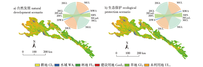
【目的】 揭示未来土地利用变化下祁连山自然保护区生境质量潜在问题及冲突,响应“山水林田湖草沙”生命共同体理念下区域生态环境保护政策,为区域生态管理与可持续发展提供科学依据。【方法】 基于2000—2020年5期土地利用数据,利用PLUS模型对未来2030年不同情境下的土地利用进行模拟,耦合InVEST模型对祁连山自然保护区生境质量的现状及未来进行评估与预测。【结果】 ①祁连山自然保护区土地利用方式以草地、林地和未利用地为主,生态用地面积增加;②2030年生态保护情景下生态用地面积的增长要明显多于自然发展情景;③研究区生境质量呈现“西北低、东南高”的空间分布格局,2000—2020年5期的生境质量均值分别为0.656 2、0.656 3、0.665 8、0.664 6和0.665 7,呈现先上升再下降后又上升的波动趋势,2030年生态保护情景下的生境质量均值为0.667 9,自然发展情景下的生境质量均值为0.665 6,生态保护情景下的生境贡献度总和大于自然发展情景;④2000—2030年间生境退化度先上升后下降,在空间上呈现从中心向外由弱到强的圈层分布关系,强退化区主要分布于与未利用地及受人类活动影响较强区域相接的草地边缘。【结论】 祁连山自然保护区生境质量整体向好发展,未来生态保护情景下的生境质量明显好于自然发展情景,加强对林地和草地等生态用地的保护有利于保护区生境质量的提升。

Abstract

【Objective】 To explore the potential problems and conflicts of habitat quality in the Qilianshan Nature Reserve as per future land use changes; to respond to the regional ecological environmental protection policy per the concept of “Mountain, Water, Forest, Field, Lake, Grass, and Sand”, and to provide a scientific basis for regional ecological management and sustainable development. 【Method】 Based on five phases of land use data from 2000 to 2020, the PLUS model was used to simulate land use under different scenarios in the future through 2030. The InVEST model was coupled to assess and predict the current and future habitat quality of the Qilian Mountain Nature Reserve. 【Results】 Land use in the Qilian Mountain Nature Reserve was dominated by grassland, forest land, and unused land, and an increase in the area of ecological land. The increase in the area of ecological land under the ecological protection scenario was significantly higher than under the natural development scenario for 2030. Habitat quality showed a spatial distribution pattern of “low in the northwest and high in the southeast,” with the mean value of habitat quality from 2000 to 2020 as follows: 0.656 2, 0.656 3, 0.665 8, 0.664 6, and 0.665 7, respectively. This showed a fluctuating trend of increasing, decreasing, and increasing values. The average value of habitat quality in 2030 was 0.667 9 under the ecological protection scenario and 0.665 6 under the natural development scenario. The total habitat contribution under the ecological protection scenario was greater than that under the natural development scenario. The degree of habitat degradation increased and then decreased from 2000 to 2030, showed a spatial distribution from weak to strong circles from the center outwards, with the most degraded areas located at the edges of grassland adjacent to unused land—the areas most affected by human activities. 【Conclusion】 The habitat quality of the Qilian Mountain Nature Reserve is developing in a positive direction; the habitat quality under the future ecological protection scenario is significantly better than that under the natural development scenario; strengthening the protection of ecological land such as woodland and grassland is conducive to the improvement of habitat quality.

关键词

生境质量 / 土地利用 / PLUS模型 / InVEST模型 / 祁连山自然保护区

Key words

habitat quality / land use / PLUS model / InVEST model / the Qilian Mountain Nature Reserve

引用本文

导出引用
张莹, 王让会, 刘春伟, . 祁连山自然保护区生境质量模拟及预测[J]. 南京林业大学学报(自然科学版). 2024, 48(3): 135-144 https://doi.org/10.12302/j.issn.1000-2006.202211025
ZHANG Ying, WANG Ranghui, LIU Chunwei, et al. Simulation and prediction of habitat quality in the Qilian Mountain Nature Reserve[J]. JOURNAL OF NANJING FORESTRY UNIVERSITY. 2024, 48(3): 135-144 https://doi.org/10.12302/j.issn.1000-2006.202211025
中图分类号: S759.9;X826   

参考文献

[1]
王建华, 田景汉, 吕宪国. 挠力河流域河流生境质量评价[J]. 生态学报, 2010, 30(2):481-486.
WANG J H, TIAN J H, LYU X G. Assessment of stream habitat quality in Naoli River watershed,China[J]. Acta Ecol Sin, 2010, 30(2):481-486.
[2]
钟莉娜, 王军. 基于InVEST模型评估土地整治对生境质量的影响[J]. 农业工程学报, 2017, 33(1):250-255.
ZHONG L N, WANG J. Evaluation on effect of land consolidation on habitat quality based on InVEST model[J]. Trans Chin Soc Agric Eng, 2017, 33(1):250-255.DOI: 10.11975/j.issn.1002-6819.2017.01.034.
[3]
吴健生, 毛家颖, 林倩, 等. 基于生境质量的城市增长边界研究:以长三角地区为例[J]. 地理科学, 2017, 37(1):28-36.
WU J S, MAO J Y, LIN Q, et al. Urban growth boundary based on the evaluation of habitat quality:taking the Yangtze River delta as an example[J]. Sci Geogr Sin, 2017, 37(1):28-36.DOI: 10.13249/j.cnki.sgs.2017.01.004.
[4]
郑宇, 张蓬涛, 汤峰, 等. 基于InVEST模型的昌黎县土地利用变化对生境质量的影响研究[J]. 中国农业资源与区划, 2018, 39(7):121-128.
ZHENG Y, ZHANG P T, TANG F, et al. The effects of land use change on habitat quality in Changli County based on InVEST model[J]. Chin J Agric Resour Reg Plan, 2018, 39(7): 121-128.DOI: 10.7621/cjarrp.1005-9121.20180718.
[5]
GOMES E, BANOS A, ABRANTES P, et al. Future land use changes in a peri-urban context:local stakeholder views[J]. Sci Total Environ, 2020, 718:137381.DOI: 10.1016/j.scitotenv.2020.137381.
[6]
HUANG W J, AN Y T, PAN Y, et al. Predicting transient particle transport in periodic ventilation using Markov chain model with pre-stored transition probabilities[J]. Build Environ, 2022, 211:108730.DOI: 10.1016/j.buildenv.2021.108730.
[7]
MOKARRAM M, PHAM T M. CA-Markov model application to predict crop yield using remote sensing indices[J]. Ecol Indic, 2022, 139:108952.DOI: 10.1016/j.ecolind.2022.108952.
[8]
褚琳, 张欣然, 王天巍, 等. 基于CA-Markov和InVEST模型的城市景观格局与生境质量时空演变及预测[J]. 应用生态学报, 2018, 29(12):4106-4118.
CHU L, ZHANG X R, WANG T W, et al. Spatial-temporal evolution and prediction of urban landscape pattern and habitat quality based on CA-Markov and InVEST model[J]. Chin J Appl Ecol, 2018, 29(12):4106-4118.DOI: 10.13287/j.1001-9332.201812.013.
[9]
VERBURG P H, SOEPBOER W, VELDKAMP A, et al. Modeling the spatial dynamics of regional land use:the CLUE-S model[J]. Environ Manage, 2002, 30(3):391-405.DOI: 10.1007/s00267-002-2630-x.
[10]
LIANG X, LIU X P, LI X, et al. Delineating multi-scenario urban growth boundaries with a CA-based FLUS model and morphological method[J]. Landsc Urban Plan, 2018, 177:47-63.DOI: 10.1016/j.landurbplan.2018.04.016.
[11]
陈霆, 徐伟铭, 吴升, 等. 国土空间规划视角下的城镇开发边界划定和空间管控体系构建[J]. 地球信息科学学报, 2022, 24(2):263-279.
CHEN T, XU W M, WU S, et al. Delimitation of urban development boundary and construction of space control system from the perspective of territorial spatial planning[J]. J Geo Inf Sci, 2022, 24(2):263-279.DOI: 10.12082/dqxxkx.2022.210552.
[12]
LIANG X, GUAN Q F, CLARKE K C, et al. Understanding the drivers of sustainable land expansion using a patch-generating land use simulation (PLUS) model:a case study in Wuhan,China[J]. Comput Environ Urban Syst, 2021, 85:101569.DOI: 10.1016/j.compenvurbsys.2020.101569.
[13]
VAN HORNE B. Density as a misleading indicator of habitat quality[J]. J Wildl Manag, 1983, 47(4):893-901.DOI: 10.2307/3808148.
[14]
XU J, XIE G D, XIAO Y, et al. Dynamic analysis of ecological environment quality combined with water conservation changes in national key ecological function areas in China[J]. Sustainability, 2018, 10(4): 1202.DOI: 10.3390/su10041202.
[15]
徐洁, 谢高地, 肖玉, 等. 国家重点生态功能区生态环境质量变化动态分析[J]. 生态学报, 2019, 39(9):3039-3050.
XU J, XIE G D, XIAO Y, et al. Dynamic analysis of ecological environmental quality changes in national key ecological function areas in China[J]. Acta Ecol Sin, 2019, 39(9):3039-3050.DOI: 10.5846/stxb201806011227.
[16]
王让会, 赵文斐, 彭擎, 等. 气候变化及景观格局与生态系统碳储存的耦合关系:以祁连山为例[J]. 干旱区研究, 2022, 39(1):250-257.
WANG R H, ZHAO W F, PENG Q, et al. The relationship of climate change and landscape pattern with ecosystem carbon storage:a case study from the Qilian Mountains[J]. Arid Zone Res, 2022, 39(1):250-257.DOI: 10.13866/j.azr.2022.01.24.
[17]
LI C, WU Y M, GAO B P, et al. Multi-scenario simulation of ecosystem service value for optimization of land use in the Sichuan-Yunnan ecological barrier,China[J]. Ecol Indic, 2021, 132:108328.DOI: 10.1016/j.ecolind.2021.108328.
[18]
AHMAD KURNIA A, RUSTIADI E, FAUZI A, et al. Understanding industrial land development on rural-urban land transformation of Jakarta megacity’s outer suburb[J]. Land, 2022, 11(5):670.DOI: 10.3390/land11050670.
[19]
张大川, 刘小平, 姚尧, 等. 基于随机森林CA的东莞市多类土地利用变化模拟[J]. 地理与地理信息科学, 2016, 32(5):29-36,127.
ZHANG D C, LIU X P, YAO Y, et al. Simulating spatiotemporal change of multiple land use types in Dongguan by using random forest based on cellular automata[J]. Geogr Geo Inf Sci, 2016, 32(5):29-36,127.DOI: 10.3969/j.issn.1672-0504.2016.05.005.
[20]
PRASAD P, LOVESON V J, CHANDRA P, et al. Evaluation and comparison of the earth observing sensors in land cover/land use studies using machine learning algorithms[J]. Ecol Inform, 2022, 68:101522.DOI: 10.1016/j.ecoinf.2021.101522.
[21]
CHEN X, YU L, DU Z R, et al. Distribution of ecological restoration projects associated with land use and land cover change in China and their ecological impacts[J]. Sci Total Environ, 2022, 825:153938.DOI: 10.1016/j.scitotenv.2022.153938.
[22]
XUE CL, ZHANG H Q, WU S M, et al. Spatial-temporal evolution of ecosystem services and its potential drivers:a geospatial perspective from Bairin Left Banner,China[J]. Ecol Indic, 2022, 137:108760.DOI: 10.1016/j.ecolind.2022.108760.
[23]
张学儒, 周杰, 李梦梅. 基于土地利用格局重建的区域生境质量时空变化分析[J]. 地理学报, 2020, 75(1):160-178.
ZHANG X R, ZHOU J, LI M M. Analysis on spatial and temporal changes of regional habitat quality based on the spatial pattern reconstruction of land use[J]. Acta Geogr Sin, 2020, 75(1):160-178.DOI: 10.11821/dlxb202001012.
[24]
包玉斌, 刘康, 李婷, 等. 基于InVEST模型的土地利用变化对生境的影响:以陕西省黄河湿地自然保护区为例[J]. 干旱区研究, 2015, 32(3):622-629.
BAO Y B, LIU K, LI T, et al. Effects of land use change on habitat based on InVEST model: taking Yellow River Wetland Nature Reserve in Shaanxi Province as an example[J]. Arid Zone Res, 2015, 32(3):622-629.DOI: 10.13866/j.azr.2015.03.29.
[25]
李潇, 杨加猛, 陈禹衡, 等. 基于土地利用变化的江苏盐城湿地自然保护区生境质量评估[J]. 南京林业大学学报(自然科学版), 2022, 46(5): 169-176.
LI X, YANG JM, CHEN Y H, et al. Evaluations of habitat quality of Jiangsu Yancheng Wetland National Nature Rare Bird Reserve based on land use changes[J]. J Nanjing For Univ (Nat Sci Ed), 2022, 46(5): 169-176.DOI: 10.12302/j.issn.1000-2006.202105002.
[26]
和娟, 师学义, 付扬军, 等. 汾河源头区域土地利用及生境质量时空演变的多情景模拟[J]. 水土保持研究, 2020, 27(5):250-258.
HE J, SHI X Y, FU Y J, et al. Multi-scenario simulation of spatiotemporal evolution of land use and habitat quality in the source area of Fenhe River basin[J]. Res Soil Water Conserv, 2020, 27(5): 250-258. DOI: 10.13869/j.cnki.rswc.2020.05.033.

基金

国家重点研发计划(2019YFC0507403)

编辑: 郑琰燚
PDF(3342 KB)

Accesses

Citation

Detail

段落导航
相关文章

/