| [1] |
王毅. 中国国家公园顶层制度设计的实践与创新[J]. 生物多样性, 2017, 25(10):1037-1039.
doi: 10.17520/biods.2017276
|
|
WANG Y. Practice and innovation for overarching institution design of China’s national park[J]. Biodivers Sci, 2017, 25(10):1037-1039.DOI: 10.17520/biods.2017276.
doi: 10.17520/biods.2017276
|
| [2] |
杨锐, 曹越. 论中国自然保护地的远景规模[J]. 中国园林, 2018, 34(7):5-12.
|
|
YANG R, CAO Y. Discussion on the long-term target of protected area coverage in China[J]. Chin Landsc Archit, 2018, 34(7):5-12.DOI: 10.3969/j.issn.1000-6664.2018.07.002.
doi: 10.3969/j.issn.1000-6664.2018.07.002
|
| [3] |
LOVEJOY T E. Protected areas:a prism for a changing world[J]. Trends Ecol Evol, 2006, 21(6):329-333.DOI: 10.1016/j.tree.2006.04.005.
doi: 10.1016/j.tree.2006.04.005
|
| [4] |
MASCIA M B. The human dimension of coral reef marine protected areas:recent social science research and its policy implications[J]. Conserv Biol, 2003, 17(2):630-632.DOI: 10.1046/j.1523-1739.2003.01454.x.
doi: 10.1046/j.1523-1739.2003.01454.x.
|
| [5] |
CHAPE S, HARRISON J, SPALDING M, et al. Measuring the extent and effectiveness of protected areas as an indicator for meeting global biodiversity targets[J]. Philos Trans Royal Soc Lond Ser B Biol Sci, 2005, 360(1454):443-455.DOI: 10.1098/rstb.2004.1592.
doi: 10.1098/rstb.2004.1592
|
| [6] |
DEWAR K. Tourism in national parks and protected areas:planning and management[J]. Tour Manag, 2004, 25(2):288-289.DOI: 10.1016/s0261-5177(03)00091-8.
doi: 10.1016/s0261-5177(03)00091-8
|
| [7] |
CETIN M, SEVIK H. Evaluating the recreation potential of ilgaz mountain national park in Turkey[J]. Environ Monit Assess, 2016, 188(1):52.DOI: 10.1007/s10661-015-5064-7.
doi: 10.1007/s10661-015-5064-7
|
| [8] |
孔石, 曾頔, 杨宇博, 等. 中国国家级自然保护区与森林公园空间分布差异比较[J]. 东北农业大学学报, 2013, 44(11):56-61.
|
|
KONG S, ZENG D, YANG Y B, et al. Spatial differences comparison between national nature reserves and national forest park[J]. J Northeast Agric Univ, 2013, 44(11):56-61.DOI: 10.19720/j.cnki.issn.1005-9369.2013.11.011.
doi: 10.19720/j.cnki.issn.1005-9369.2013.11.011
|
| [9] |
姜超, 马社刚, 王琦淞, 等. 中国5种主要保护地类型的空间分布格局[J]. 野生动物学报, 2016, 37(1):61-66.
|
|
JIANG C, MA S G, WANG Q S, et al. Spatial distribution pattern of five major categories of protected area in China[J]. Chin J Wildl, 2016, 37(1):61-66.DOI: 10.19711/j.cnki.issn2310-1490.2016.01.012.
doi: 10.19711/j.cnki.issn2310-1490.2016.01.012
|
| [10] |
杨振, 程鲲, 付励强, 等. 东北林业系统自然保护区、森林公园和湿地公园的空间重叠分析[J]. 生态学杂志, 2017, 36(11):3305-3310.
|
|
YANG Z, CHENG K, FU L Q, et al. Spatial overlapping analysis for nature reserves,forest parks and wetland parks in forestry management system of northeast China[J]. Chin J Ecol, 2017, 36(11):3305-3310.DOI: 10.13292/j.1000-4890.201711.008.
doi: 10.13292/j.1000-4890.201711.008
|
| [11] |
郭子良, 张曼胤, 崔丽娟, 等. 中国国家湿地公园的建设布局及其动态[J]. 生态学杂志, 2019, 38(2):532-540.
|
|
GUO Z L, ZHANG M Y, CUI L J, et al. Establishment and dynamics of national wetland park system in China[J]. Chin J Ecol, 2019, 38(2):532-540.DOI: 10.13292/j.1000-4890.201902.008.
doi: 10.13292/j.1000-4890.201902.008
|
| [12] |
马童慧, 吕偲, 雷光春. 中国自然保护地空间重叠分析与保护地体系优化整合对策[J]. 生物多样性, 2019, 27(7):758-771.
doi: 10.17520/biods.2019087
|
|
MA T H, LÜ C, LEI G C. The spatial overlapping analysis for China’s natural protected area and countermeasures for the optimization and integration of protected area system[J]. Biodivers Sci, 2019, 27(7):758-771.DOI: 10.17520/biods.2019087.
doi: 10.17520/biods.2019087
|
| [13] |
欧阳志云, 徐卫华, 杜傲, 等. 中国国家公园总体空间布局研究[M]. 北京: 中国环境出版集团, 2018.
|
|
OUYANG Z Y, XU W H, DU A, et al. Research on overall spatical planning for China’s national park system[M]. Beijing: China Environmental Science Press, 2018.
|
| [14] |
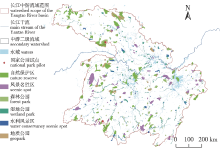
张卓然, 唐晓岚, 贾艳艳. 保护地空间分布特征与影响因素分析:以长江中下游为例[J]. 安徽农业大学学报, 2017, 44(3):439-447.
|
|
ZHANG Z R, TANG X L, JIA Y Y. Spatial distribution characteristics and influencing factors of protected areas: a case of middle and lower reaches of Yangtze River[J]. J Anhui Agric Univ, 2017, 44(3):439-447.DOI: 10.13610/j.cnki.1672-352x.20170524.022.
doi: 10.13610/j.cnki.1672-352x.20170524.022
|
| [15] |
王法辉. 基于GIS的数量方法与应用[M]. 北京: 商务印书馆, 2009.
|
|
WANG F H. Quantitative method and application based on GIS[M]. Beijing: Business Printing Hall, 2009.
|
| [16] |
彭杨靖, 樊简, 邢韶华, 等. 中国大陆自然保护地概况及分类体系构想[J]. 生物多样性, 2018, 26(3):315-325.
doi: 10.17520/biods.2017235
|
|
PENG Y J, FAN J, XING S H, et al. Overview and classification outlook of natural protected areas in mainland China[J]. Biodivers Sci, 2018, 26(3):315-325.DOI: 10.17520/biods.2017235.
doi: 10.17520/biods.2017235
|
| [17] |
唐芳林, 王梦君, 孙鸿雁. 建立以国家公园为主体的自然保护地体系的探讨[J]. 林业建设, 2018(1):1-5.
|
|
TANG F L, WANG M J, SUN H Y. Analysis on establishing the protected area system dominated by national park[J]. For Constr, 2018(1):1-5.
|
| [18] |
吕偲, 曾晴, 雷光春. 基于生态系统服务的保护地分类体系构建[J]. 中国园林, 2017, 33(8):19-23.
|
|
LÜ C, ZENG Q, LEI G C. Ecosystem service-based protected area category system[J]. Chin Landsc Archit, 2017, 33(8):19-23.
|
| [19] |
赵智聪, 杨锐. 论国土空间规划中自然保护地规划之定位[J]. 中国园林, 2019, 35(8):5-11.
|
|
ZHAO Z C, YANG R. On the positioning of protected area planning in national spatial planning[J]. Chin Landsc Archit, 2019, 35(8):5-11.DOI: 10.19775/j.cla.2019.08.0005.
doi: 10.19775/j.cla.2019.08.0005
|
| [20] |
HOEKSTRA J M, BOUCHER T M, RICKETTS T H, et al. Confronting a biome crisis: global disparities of habitat loss and protection[J]. Ecol Lett, 2005, 8(1):23-29.DOI: 10.1111/j.1461-0248.2004.00686.x.
doi: 10.1111/j.1461-0248.2004.00686.x.
|
| [21] |
CANTÚ-SALAZAR L, GASTON K J. Very large protected areas and their contribution to terrestrial biological conservation[J]. Bio Science, 2010, 60(10):808-818.DOI: 10.1525/bio.2010.60.10.7.
doi: 10.1525/bio.2010.60.10.7
|

 ), 马坤, 任宇杰