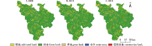
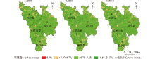
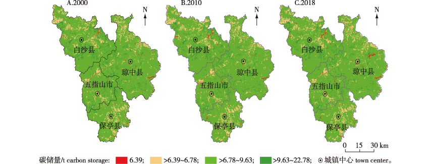
| [1] |
HOUGHTON R A. Revised estimates of the annual net flux of carbon to the atmosphere from changes in land use and land management 1850-2000[J]. Tellus B Chem Phys Meteorol, 2003, 55(2): 378-390.DOI: 10.1034/j.1600-0889.2003.01450.x.
|
| [2] |
马晓哲, 王铮. 土地利用变化对区域碳源汇的影响研究进展[J]. 生态学报, 2015, 35(17):5898-5907.
|
|
MA X Z, WANG Z. Progress in the study on the impact of land-use change on regional carbon sources and sinks[J]. Acta Ecol Sin, 2015, 35(17):5898-5907.DOI:10.5846/stxb201312112932.
|
| [3] |
刘魏魏, 王效科, 逯非, 等. 全球森林生态系统碳储量、固碳能力估算及其区域特征[J]. 应用生态学报, 2015, 26(9):2881-2890.
|
|
LIU W W, WANG X K, LU F, et al. Regional and global estimates of carbon stocks and carbon sequestration capacity in forest ecosystems: a review[J]. Chin J Appl Ecol, 2015, 26(9):2881-2890.DOI:10.13287/j.1001-9332.20150630.005.
|
| [4] |
李云红, 邵英男, 陈瑶, 等. 云冷杉红松林和蒙古栎红松林对土壤活性有机碳含量的影响[J]. 森林工程, 2021, 37(3): 60-66.
|
|
LI Y H, SHAO Y N, CHEN Y, et al. Effects of Picea sp.-Abies sp.-Pinus koraiensis forests and Quercus mongolica-Pinus koraiensis forests on soil labile organic carbon content[J]. Forest Engineering, 2021, 37(3): 60-66. DOI:10.16270/j.cnki.slgc.2021.03.008.
|
| [5] |
周汝波, 林媚珍, 吴卓, 等. 珠江西岸生态系统碳储量对土地利用变化的响应[J]. 生态科学, 2018, 37(6):175-183.
|
|
ZHOU R B, LIN M Z, WU Z, et al. Responses of ecosystem carbon stocks to land use change on the west side of the Pearl River[J]. Ecol Sci, 2018, 37(6):175-183. DOI:10.14108/j.cnki.1008-8873.2018.06.023.
|
| [6] |
张文华, 贾志斌, 卓义, 等. InVEST模型对锡林郭勒草原碳储量研究的适用性分析[J]. 地球环境学报, 2016, 7(1):87-96.
|
|
ZHANG W H, JIA Z B, ZHUO Y, et al. Applicability research on carbon storage in the Xilin Gol grassland by InVEST model[J]. J Earth Environ, 2016, 7(1):87-96.DOI:10.7515/JEE201601010.
|
| [7] |
吴哲, 陈歆, 刘贝贝, 等. InVEST模型及其应用的研究进展[J]. 热带农业科学, 2013, 33(4):58-62.
|
|
WU Z, CHEN X, LIU B B, et al. Research progress and application of InVEST model[J]. Chin J Trop Agric, 2013, 33(4):58-62.DOI: 10.3969/j.issn.1009-2196.2013.04.012.
|
| [8] |
邓元杰, 姚顺波, 侯孟阳, 等. 退耕还林还草工程对生态系统碳储存服务的影响:黄土高原丘陵沟壑区子长县为例[J]. 自然资源学报, 2020, 35(4):826-844.
|
|
DENG Y J, YAO S B, HOU M Y, et al. Assessing the effects of the Green for Grain Program on ecosystem carbon storage service by linking the InVEST and FLUS models:a case study of Zichang County in hilly and gully region of Loess Plateau[J]. J Nat Resour, 2020, 35(4):826-844.DOI:10.31497/zrzyxb.20200407.
|
| [9] |
刘晓娟, 黎夏, 梁迅, 等. 基于FLUS-InVEST模型的中国未来土地利用变化及其对碳储量影响的模拟[J]. 热带地理, 2019, 39(3):397-409.
|
|
LIU X J, LI X, LIANG X, et al. Simulating the change of terrestrial carbon storage in China based on the FLUS-InVEST model[J]. Trop Geogr, 2019, 39(3):397-409.DOI:10.13284/j.cnki.rddl.003138.
|
| [10] |
张燕, 师学义, 唐倩. 不同土地利用情景下汾河上游地区碳储量评估[J]. 生态学报, 2021, 41(1):360-373.
|
|
ZHANG Y, SHI X Y, TANG Q. Carbon storage assessment in the upper reaches of the Fenhe River under different land use scenarios[J]. Acta Ecol Sin, 2021, 41(1):360-373.DOI:10.5846/stxb201909242005.
|
| [11] |
杨洁, 谢保鹏, 张德罡. 基于InVEST和CA-Markov模型的黄河流域碳储量时空变化研究[J]. 中国生态农业学报(中英文), 2021, 29(6):1018-1029.
|
|
YANG J, XIE B P, ZHANG D G. Spatio-temporal evolution of carbon stocks in the Yellow River Basin based on InVEST and CA-Markov models[J]. Chinese Journal of Eco-Agriculture, 2021, 29(6):1018-1029.DOI:10.13930/j.cnki.cjea.200746.
|
| [12] |
LIANG X, GUAN Q F, CLARKE K C, et al. Understanding the drivers of sustainable land expansion using a patch-generating land use simulation (PLUS) model:a case study in Wuhan,China[J]. Comput Environ Urban Syst, 2021, 85:101569.DOI:10.1016/j.compenvurbsys.2020.101569.
|
| [13] |
SHI M J, WU H Q, FAN X, et al. Trade-offs and synergies of multiple ecosystem services for different land use scenarios in the Yili River valley,China[J]. Sustainability, 2021, 13(3):1577.DOI:10.3390/su13031577.
|
| [14] |
HAN N, YU M, JIA P. Multi-scenario landscape ecological risk simulation for sustainable development goals: a case study on the central mountainous area of Hainan Island[J]. International Journal of Environmental Research and Public Health, 2022, 19(7): 4030.
|
| [15] |
FANG J Y, WANG Z M. Forest biomass estimation at regional and global levels,with special reference to China’s forest biomass[J]. Ecol Res, 2001, 16(3):587-592.DOI:10.1046/j.1440-1703.2001.00419.x.
|
| [16] |
叶金盛, 佘光辉. 广东省森林植被碳储量动态研究[J]. 南京林业大学学报(自然科学版), 2010, 34(4):7-12.
|
|
YE J S, SHE G H. Forest carbon dynamics in Guangdong Province[J]. J Nanjing For Univ (Nat Sci Ed), 2010, 34(4):7-12.DOI:10.3969/j.jssn.1000-2006.2010.04.002.
|
| [17] |
方精云, 刘国华, 徐嵩龄. 我国森林植被的生物量和净生产量[J]. 生态学报, 1996, 16(5):497-508.
|
|
FANG J Y, LIU G H, XU S L. Biomass and net production of forest vegetation in China[J]. Acta Ecol Sin, 1996, 16(5):497-508.
|
| [18] |
朴世龙, 方精云, 贺金生, 等. 中国草地植被生物量及其空间分布格局[J]. 植物生态学报, 2004, 28(4):491-498.
|
|
PIAO S L, FANG J Y, HE J S, et al. Spatial distribution of grassland biomass in China[J]. Acta Phytoecol Sin, 2004, 28(4):491-498.DOI: 10.17521/cjpe.2004.0067.
|
| [19] |
LIU X P, LIANG X, Li X, et al. A future land use simulation model (FLUS) for simulating multiple land use scenarios by coupling human and natural effects[J]. Landsc Urban Plan, 2017, 168: 94-116.DOI: 10.1016/j.landurbplan.2017.09.019.
|
| [20] |
韩念龙, 张亦清, 张伟璇. 海南岛土地利用及产水量时空变化模拟[J]. 水资源保护, 2022, 38(2):119-127.
|
|
HAN N L, ZHANG Y Q, ZHANG W X. Simulation of temporal and spatial changes of land use and water yield in Hainan Island[J]. Water Resour Prot, 2022, 38(2):119-127.DOI:10.3880/j.issn.1004-6933.2022.02.017.
|
| [21] |
胡杰龙, 辛琨, 李真, 等. 海南东寨港红树林保护区碳储量及固碳功能价值评估[J]. 湿地科学, 2015, 13(3):338-343.
|
|
HU J L, XIN K, LI Z, et al. Carbon storage and sequestration function evaluation in Dongzhaigang Mangrove Reserve of Hainan[J]. Wetl Sci, 2015, 13(3):338-343.DOI:10.13248/j.cnki.wetlandsci.2015.03.011.
|
| [22] |
朱美玲, 王旭, 王帅, 等. 海南岛典型地区桉树人工林生态系统碳、氮储量及其分配格局[J]. 热带作物学报, 2015, 36(11):1943-1950.
|
|
ZHU M L, WANG X, WANG S, et al. Carbon and nitrogen storage allocation of eucalyptus plantations in Hainan[J]. Chin J Trop Crops, 2015, 36(11):1943-1950.DOI:10.3969/j.issn.1000-2561.2015.11.005.
|
| [23] |
王明哲, 崔晓阳, 李斯雯, 等. 大兴安岭北端地形因子对针叶林土壤黑碳储量的影响[J]. 南京林业大学学报(自然科学版), 2021, 45(1): 151-158.
|
|
WANG M Z, CUI X Y, LI S W, et al. Effects of topographic factors on soil black carbon storage in coniferous forests at the north end of Greater Khingan Mountains[J]. J Nanjing For Univ (Nat Sci Ed), 2021, 45(1): 151-158.DOI: 10.12302/j.issn.1000-2006.201907005.
|
| [24] |
曹军, 张镱锂, 刘燕华. 近20年海南岛森林生态系统碳储量变化[J]. 地理研究, 2002, 21(5):551-560.
|
|
CAO J, ZHANG Y L, LIU Y H. Changes in forest biomass carbon storage in Hainan Island over the last 20 years[J]. Geogr Res, 2002, 21(5):551-560.DOI:10.11821/yj2002050003.
|

 ), 韩念龙1,3,*(