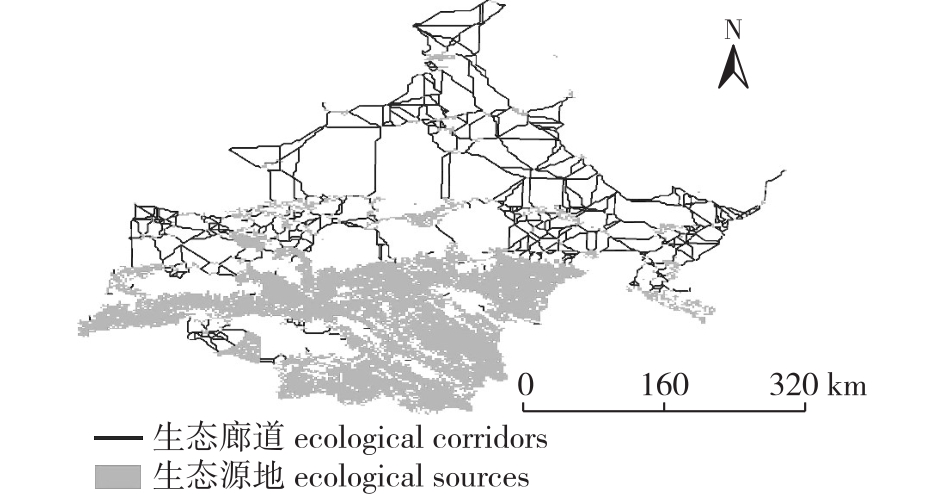
| [1] |
徐涵秋. 城市遥感生态指数的创建及其应用[J]. 生态学报, 2013, 33(24):7853-7862.
|
|
XU H Q. A remote sensing urban ecological index and its application[J]. Acta Ecol Sin, 2013, 33(24):7853-7862.DOI: 10.5846/stxb201208301223.
|
| [2] |
孙桂凯, 王国帅, 魏义熊, 等. 基于改进遥感生态指数的岩溶山区生态质量评价:以澄碧河流域为例[J]. 水土保持通报, 2021, 41(2):230-239,F0003.
|
|
SUN G K, WANG G S, WEI Y X, et al. Improvement of remote sensing ecological index in Karst mountainous areas:taking Chengbi River basin as an example[J]. Bull Soil Water Conserv, 2021, 41(2):230-239,F0003.DOI: 10.13624/j.cnki.issn.1001-7445.2020.0248.
|
| [3] |
王小宇. 基于遥感生态指数的石漠化地区生态环境质量评价:以贵州花江示范区为例[D]. 贵阳: 贵州师范大学, 2019.
|
|
WANG X Y. Evaluation of eco-environmental quality in rocky desertification area based on remote sensing ecological index:a case study of Huajiang Demonstration Zone in Guizhou Province[D]. Guiyang: Guizhou Normal University, 2019.
|
| [4] |
彭燕, 何国金, 张兆明, 等. 赣南稀土矿开发区生态环境遥感动态监测与评估[J]. 生态学报, 2016, 36(6):1676-1685.
|
|
PENG Y, HE G J, ZHANG Z M, et al. Eco-environmental dynamic monitoring and assessment of rare earth mining area in southern Ganzhou using remote sensing[J]. Acta Ecol Sin, 2016, 36(6):1676-1685.
|
| [5] |
于强, 张启斌, 牛腾, 等. 绿色生态空间网络研究进展[J]. 农业机械学报, 2021, 52(12):1-15.
|
|
YU Q, ZHANG Q B, NIU T, et al. Research progress and prospect of green ecological space network[J]. Trans Chin Soc Agric Mach, 2021, 52(12):1-15.DOI: 10.6041/j.issn.1000-1298.2021.12.001.
|
| [6] |
于强, 岳德鹏, 张启斌, 等. 磴口县景观格局演变特征及生态网络构建[J]. 中国沙漠, 2017, 37(3):601-609.
|
|
YU Q, YUE D P, ZHANG Q B, et al. The evolution of landscape pattern and the construction of ecological infrastructure network in Dengkou,Inner Mongolia,China[J]. J Desert Res, 2017, 37(3):601-609.
|
| [7] |
马仲武, 王新源, 王小军, 等. 甘肃省酒泉市土地沙漠化现状及动态分析[J]. 中国农业资源与区划, 2018, 39(3):141-147.
|
|
MA Z W, WANG X Y, WANG X J, et al. Present situation and dynamic analysis of land desertification in Jiuquan City,Gansu Province[J]. Chin J Agric Resour Reg Plan, 2018, 39(3):141-147.DOI: 10.7621/cjarrp.1005-9121.20180320.
|
| [8] |
刘凌冰, 李世平. 西北荒漠化地区土地生态安全评价:以酒泉市为例[J]. 水土保持研究, 2014, 21(4):190-194,202.
|
|
LIU L B, LI S P. Evaluation on land ecological security in desertification areas of northwest China:a case study of Jiuquan city[J]. Res Soil Water Conserv, 2014, 21(4):190-194,202.DOI: 10.3969/j.issn.1001-8158.2011.05.008.
|
| [9] |
牛腾, 岳德鹏, 张启斌, 等. 潜在生态网络空间结构与特性研究[J]. 农业机械学报, 2019, 50(8):166-175.
|
|
NIU T, YUE D P, ZHANG Q B, et al. Spatial structure and characteristics of potential ecological networks[J]. Trans Chin Soc Agric Mach, 2019, 50(8):166-175.DOI: 10.6041/j.issn.1000-1298.2019.08.019.
|
| [10] |
王戈, 于强, YANG D, 等. 基于复杂网络分析法的层级生态网络结构研究[J]. 农业机械学报, 2019, 50(7):258-266,312.
|
|
WANG G, YU Q, YANG D, et al. Hierarchical ecological network structure based on complex network analysis[J]. Trans Chin Soc Agric Mach, 2019, 50(7):258-266,312.DOI: 10.6041/j.issn.1000-1298.2019.07.028.
|
| [11] |
裴燕如, 孙炎浩, 于强, 等. 黄河流域典型矿区生态空间网络优化:以鄂榆地区为例[J]. 煤炭学报, 2021, 46(5):1541-1554.
|
|
PEI Y R, SUN Y H, YU Q, et al. Optimization of ecological spatial network in typical mining areas of the Yellow River basin:take Ordos and Yulin areas of the Yellow River basin as examples[J]. J China Coal Soc, 2021, 46(5):1541-1554.DOI: 10.13225/j.cnki.jccs.ST21.8218.
|
| [12] |
XIONG Y, XU W H, LU N, et al. Assessment of spatial-temporal changes of ecological environment quality based on RSEI and GEE:a case study in Erhai Lake basin,Yunnan Province,China[J]. Ecol Indic, 2021, 125:107518.DOI: 10.1016/j.ecolind.2021.107518.
|
| [13] |
SAHANI N. Assessment of spatio-temporal changes of land surface temperature (LST) in Kanchenjunga Biosphere Reserve (KBR), India using Landsat satellite image and single channel algorithm[J]. Remote Sens Appl, 2021, 24:100659.DOI: 10.1016/j.rsase.2021.100659.
|
| [14] |
KNAAPEN J P, SCHEFFER M, HARMS B. Estimating habitat isolation in landscape planning[J]. Landsc Urban Plan, 1992, 23(1):1-16.DOI: 10.1016/0169-2046(92)90060-D.
|
| [15] |
王雪然, 万荣荣, 潘佩佩. 太湖流域生态安全格局构建与调控:基于空间形态学-最小累积阻力模型[J]. 生态学报, 2022, 42(5):1968-1980.
|
|
WANG X R, WAN R R, PAN P P. Construction and adjustment of ecological security pattern based on MSPA-MCR model in Taihu Lake basin[J]. Acta Ecol Sin, 2022, 42(5):1968-1980.DOI: 10.5846/stxb202103020571.
|
| [16] |
张启斌. 乌兰布和沙漠东北缘生态网络构建与优化研究[D]. 北京: 北京林业大学.
|
|
ZHANG Q B. Study on the construction and optimization of ecological network in the northeast edge of Wulanbuhe desert[D]. Beijing: Beijing Forestry University.
|
| [17] |
王戈, 于强, YANG D, 等. 包头市层级生态网络构建方法研究[J]. 农业机械学报, 2019, 50(9):235-242,207.
|
|
WANG G, YU Q, YANG D, et al. Construction method of hierarchical ecological network in Baotou City[J]. Trans Chin Soc Agric Mach, 2019, 50(9):235-242,207.DOI: 10.6041/j.issn.1000-1298.2019.09.028.
|
| [18] |
王戈. 京津冀生态空间网络与区域热环境关系研究[D]. 北京: 北京林业大学.
|
|
WANG G. Study on the relationship between Beijing-Tianjin-Hebei ecological space network and regional thermal environment[D]. Beijing: Beijing Forestry University.
|
| [19] |
周东东. 城市存量开发中生态空间优化策略研究——“生态踏脚石”在存量生态空间的应用模型[C]// 持续发展理性规划——2017中国城市规划年会论文集(08城市生态规划). 2017:232-241.
|
| [20] |
周涛, 柏文洁, 汪秉宏, 等. 复杂网络研究概述[J]. 物理, 2005, 34(1):31-36.
|
|
ZHOU T, BAI W J, WANG B H, et al. A brief review of complex networks[J]. Physics, 2005, 34(1):31-36.DOI: 10.3321/j.issn:0379-4148.2005.01.007.
|
| [21] |
张娟, 文广超, 王恩营, 等. 基于遥感生态指数的焦作市生态环境动态监测与评价[J]. 水土保持通报, 2020, 40(6):107-114.
|
|
ZHANG J, WEN G C, WANG E Y, et al. Dynamic monitoring and evaluation of ecological environment at Jiaozuo City based on remote sensing ecological index[J]. Bull Soil Water Conserv, 2020, 40(6):107-114.DOI: 10.3969/j.issn.1674-3504.2020.01.011.
|
| [22] |
张亚球, 姜放, 纪梦达, 等. 基于遥感指数的区县级生态环境评价[J]. 干旱区研究, 2020, 37(6):1598-1605.
|
|
ZHANG Y Q, JIANG F, JI M D, et al. Assessment of the ecological environment at district and county level based on remote sensing index[J]. Arid Zone Res, 2020, 37(6):1598-1605.DOI: 10.13866/j.azr.2020.06.26.
|
| [23] |
褚馨德, 贾伟, 张峻豪, 等. 基于RSEI模型的祁连山自然保护区生态环境质量评价[J]. 环境监测管理与技术, 2022, 34(1):38-42.
|
|
CHU X D, JIA W, ZHANG J H, et al. Ecological environment quality evaluation of Qilian Mountain nature reserve based on RSEI model[J]. Adm Tech Environ Monit, 2022, 34(1): 38-42. DOI:10.3969/j.issn.1006-2009.2022.01.008.
|
| [24] |
胡其玉, 陈松林. 基于生态系统服务供需的厦漳泉地区生态网络空间优化[J]. 自然资源学报, 2021, 36(2):342-355.
|
|
HU Q Y, CHEN S L. Optimizing the ecological networks based on the supply and demand of ecosystem services in Xiamen-Zhangzhou-Quanzhou region[J]. J Nat Resour, 2021, 36(2):342-355. DOI:10.31497/zrzyxb.20210206.
|
| [25] |
卢杰, 王戈, 马骏, 等. 基于复杂网络理论的西藏巴宜区森林景观空间结构研究[J]. 农业机械学报, 2021, 52(4):152-158.
|
|
LU J, WANG G, MA J, et al. Forest ecological network construction and structure evaluation based on complex network theory in Bayi District of Tibet[J]. Trans Chin Soc Agric Mach, 2021, 52(4):152-158. DOI:10.6041/j.issn.1000-1298.2021.04.016.
|
| [26] |
张启舜, 李飞雪, 王帝文, 等. 基于生态网络的江苏省生态空间连通性变化研究[J]. 生态学报, 2021, 41(8):3007-3020.
|
|
ZHANG Q S, LI F X, WANG D W, et al. Analysis on changes of ecological spatial connectivity in Jiangsu Province based on ecological network[J]. Act Ecol Sin, 2021, 41(8):3007-3020. DOI:10.5846/stxb202005181264.
|
| [27] |
潘竟虎, 刘晓. 疏勒河流域景观生态风险评价与生态安全格局优化构建[J]. 生态学杂志, 2016, 35(3):791-799.
|
|
PAN J H, LIU X. Landscape ecological risk assessment and landscape security pattern optimization in Shule River basin[J]. Chin J Ecol, 2016, 35(3):791-799.DOI: 10.13292/j.1000-4890.201603.022.
|
| [28] |
WU J S, ZHANG S Y, LUO Y H, et al. Assessment of risks to habitat connectivity through the stepping-stone theory:a case study from Shenzhen,China[J]. Urban For Urban Green, 2022, 71:127532.DOI: 10.1016/j.ufug.2022.127532.
|

 ), 于强*(