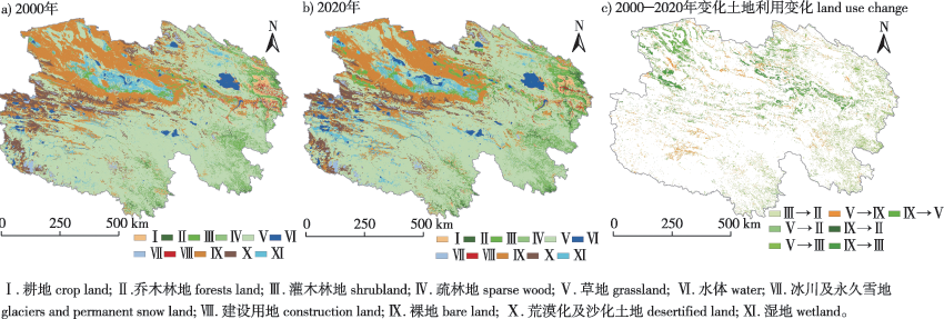
| [1] |
杨勤科, 李锐, 刘咏梅. 区域土壤侵蚀普查方法的初步讨论[J]. 中国水土保持科学, 2008, 6(3):1-6.
|
|
YANG Q K, LI R, LIU Y M. Discussions on methods of national regional soil erosion survey[J]. Sci Soil Water Conserv, 2008, 6(3):1-6.DOI:10.16843/j.sswc.2008.03.001.
|
| [2] |
CHEN T, NIU R Q, LI P X, et al. Regional soil erosion risk mapping using RUSLE,GIS,and remote sensing:a case study in Miyun Watershed,north China[J]. Environ Earth Sci, 2011, 63(3):533-541.DOI:10.1007/s12665-010-0715-z.
|
| [3] |
刘月, 赵文武, 贾立志. 土壤保持服务:概念、评估与展望[J]. 生态学报, 2019, 39(2):432-440.
|
|
LIU Y, ZHAO W W, JIA L Z. Soil conservation service:concept,assessment,and outlook[J]. Acta Ecol Sin, 2019, 39(2):432-440.DOI:10.5846/stxb201709301770.
|
| [4] |
FU B J, LIU Y, LÜ Y H, et al. Assessing the soil erosion control service of ecosystems change in the Loess Plateau of China[J]. Ecol Complex, 2011, 8(4):284-293.DOI:10.1016/j.ecocom.2011.07.003.
|
| [5] |
肖洋, 欧阳志云, 徐卫华, 等. 基于GIS重庆土壤侵蚀及土壤保持分析[J]. 生态学报, 2015, 35(21):7130-7138.
|
|
XIAO Y, OUYANG Z Y, XU W H, et al. GIS-based spatial analysis of soil erosion and soil conservation in Chongqing,China[J]. Acta Ecol Sin, 2015, 35(21):7130-7138.DOI:10.5846/stxb201309152278.
|
| [6] |
陆建忠, 陈晓玲, 李辉, 等. 基于GIS/RS和USLE鄱阳湖流域土壤侵蚀变化[J]. 农业工程学报, 2011, 27(2):337-344,397.
|
|
LU J Z, CHEN X L, LI H, et al. Soil erosion changes based on GIS/RS and USLE in Poyang Lake basin[J]. Trans Chin Soc Agric Eng, 2011, 27(2):337-344,397.DOI:10.3969/j.issn.1002-6819.2011.02.057.
|
| [7] |
杨波, 王全九, 董莉丽. 榆林市还林还草后土壤保持功能和经济价值评价[J]. 干旱区研究, 2017, 34(6):1313-1322.
|
|
YANG B, WANG Q J, DONG L L. Assessment of soil conservation function and economic value in Yulin City after implementing the project of “grain for green”[J]. Arid Zone Res, 2017, 34(6):1313-1322.DOI:10.13866/j.azr.2017.06.13.
|
| [8] |
温豪. 青海省生态保护红线划定研究与管控[D]. 西安: 西安科技大学, 2019.
|
|
WEN H. Red line delineation and control of ecological protection in Qinghai Province[D]. Xi’an: Xi’an University of Science and Technology, 2019.
|
| [9] |
青海省地方志编篡委员会. 青海年鉴[M]. 西宁: 青海年鉴社, 2020.
|
| [10] |
李小涛, 黄诗峰, 李琳, 等. 嘉陵江流域土壤侵蚀变化遥感分析[J]. 泥沙研究, 2006(6):65-69.
|
|
LI X T, HUANG S F, LI L, et al. Remote sensing analysis on soil erosion in the Jialingjiang Basin[J]. J Sediment Res, 2006(6):65-69.DOI:10.16239/j.cnki.0468-155x.2006.06.012.
|
| [11] |
张水锋, 张金池, 庄家尧, 等. 长三角小流域AnnAGNPS模型参数敏感性及适用性评价[J]. 南京林业大学学报(自然科学版), 2021, 45(3):183-192.
|
|
ZHANG S F, ZHANG J C, ZHUANG J Y, et al. Parameters sensitivity and applicability evaluations of AnnAGNPS model in a small watershed of the Yangtze River Delta[J]. J Nanjing For Univ (Nat Sci Ed), 2021, 45(3):183-192.DOI:10.12302/j.issn.1000-2006.202005003.
|
| [12] |
贾艳艳, 唐晓岚, 唐芳林, 等. 1995—2015年长江中下游流域景观格局时空演变[J]. 南京林业大学学报(自然科学版), 2020, 44(3):185-194.
|
|
JIA Y Y, TANG X L, TANG F L, et al. Spatial-temporal evolution of landscape pattern in the middle and lower reaches of the Yangtze River Basin from 1995 to 2015[J]. J Nanjing For Univ (Nat Sci Ed), 2020, 44(3):185-194.DOI:10.3969/j.issn.1000-2006.201903079.
|
| [13] |
QUANSAH C. The effect of soil type,slope,rain intensity and their interactions on splash detachment and transport[J]. Soil Sci, 1981, 32(2):215-224.DOI:10.1111/j.1365-2389.1981.tb01701.x.
|
| [14] |
史志华, 宋长青. 土壤水蚀过程研究回顾[J]. 水土保持学报, 2016, 30(5):1-10.
|
|
SHI Z H, SONG C Q. Water erosion processes:a historical review[J]. J Soil Water Conserv, 2016, 30(5):1-10.DOI:10.13870/j.cnki.stbcxb.2016.05.001.
|
| [15] |
常娟, 张增信, 田佳西, 等. 西北地区草地水分利用效率时空特征及其对气候变化的响应[J]. 南京林业大学学报(自然科学版), 2020, 44(3):119-125.
|
|
CHANG J, ZHANG Z X, TIAN J X, et al. Spatio-temporal characteristics of grassland water use efficiency and its response to climate change in northwest China[J]. J Nanjing For Univ (Nat Sci Ed), 2020, 44(3):119-125.DOI:10.3969/j.issn.1000-2006.201904012.
|
| [16] |
WILLIAMS J R. The erosion-productivity impact calculator (EPIC) model:a case history[J]. Philos Trans Biol Sci, 1990, 329(1255):421-428.DOI:10.1098/rstb.1990.0184.
|
| [17] |
田宇, 朱建华, 李奇, 等. 三峡库区土壤保持时空分布特征及其驱动力[J]. 生态学杂志, 2020, 39(4):1164-1174.
|
|
TIAN Y, ZHU J H, LI Q, et al. Spatial and temporal distribution of soil conservation and its driving forces in the Three Gorges Reservoir Area[J]. Chin J Ecol, 2020, 39(4):1164-1174.DOI:10.13292/j.1000-4890.202004.019.
|
| [18] |
DESMET P J J, GOVERS G. Comparison of routing algorithms for digital elevation models and their implications for predicting ephemeral gullies[J]. Int J Geogr Inf Syst, 1996, 10(3):311-331.DOI:10.1080/02693799608902081.
|
| [19] |
OLIVEIRA P T S, RODRIGUES D B B, SOBRINHO T A, et al. Use of SRTM data to calculate the (R)USLE topographic factor[J]. Acta Sci Technol, 2013, 35(3):507-513.DOI:10.4025/actascitechnol.v35i3.15792.
|
| [20] |
饶恩明, 肖燚, 欧阳志云, 等. 海南岛生态系统土壤保持功能空间特征及影响因素[J]. 生态学报, 2013, 33(3):746-755.
|
|
RAO E M, XIAO Y, OUYANG Z Y, et al. Spatial characteristics of soil conservation service and its impact factors in Hainan Island[J]. Acta Ecol Sin, 2013, 33(3):746-755.DOI:10.5846/stxb201203240400.
|
| [21] |
杨蕾. 基于InVEST模型的三江源主要生态系统服务权衡与协同研究[D]. 上海: 上海师范大学, 2020.
|
|
YANG L. Trade-offs and collaborative research on major ecosystem services in Sanjiangyuan based on InVEST model[D]. Shanghai: Shanghai Normal University, 2020.
|
| [22] |
肖玉, 谢高地, 安凯. 青藏高原生态系统土壤保持功能及其价值[J]. 生态学报, 2003, 23(11):2367-2378.
|
|
XIAO Y, XIE G D, AN K. The function and economic value of soil conservation of ecosystems in Qinghai-Tibet Plateau[J]. Acta Ecol Sin, 2003, 23(11):2367-2378.DOI: 10.3321/j.issn:1000-0933.2003.11.021.
|
| [23] |
何莎莎, 朱文博, 崔耀平, 等. 基于InVEST模型的太行山淇河流域土壤侵蚀特征研究[J]. 长江流域资源与环境, 2019, 28(2):426-439.
|
|
HE S S, ZHU W B, CUI Y P, et al. Study on soil erosion characteristics of Qihe watershed in Taihang Mountains based on the InVEST model[J]. Resour Environ Yangtze Basin, 2019, 28(2):426-439.DOI:10.11870/cjlyzyyhj201902019.
|
| [24] |
王婷, 郑帅霖, 李深泉, 等. 晋北地区土壤保持量时空变化特征研究[J]. 干旱区资源与环境, 2018, 32(7):188-195.
|
|
WANG T, ZHENG S L, LI S Q, et al. Temporal-spatial distribution of soil conservation and its dynamic changes in northern area of Shanxi[J]. J Arid Land Resour Environ, 2018, 32(7):188-195.DOI:10.13448/j.cnki.jalre.2018.225.
|
| [25] |
刘翊涵, 苏正安, 潘洪义, 等. 张家口市土地利用和土壤保持功能的变化特征[J]. 草业科学, 2020, 37(7):1281-1292.
|
|
LIU Y H, SU Z G, PAN H Y, et al. Changes in land use and soil retention functions in Zhangjiakou City[J]. Pratacultural Sci, 2020, 37(7):1281-1292.DOI:10.11829/j.issn.1001-0629.2020-0181.
|
| [26] |
水利部水土保持司. 水土保持综合治理规划通则:GB/T 15772—2008[S]. 北京: 中国标准出版社, 2008.
|
|
Department of Soil and Water Conservation Ministry of Water Resources. General rule of planning for comprehensive control of soil erosion:GB/T 15772—2008[S]. Beijing: Standards Press of China, 2008.
|
| [27] |
刘敏超, 李迪强, 温琰茂, 等. 三江源地区土壤保持功能空间分析及其价值评估[J]. 中国环境科学, 2005, 25(5):627-631.
|
|
LIU M C, LI D Q, WEN Y M, et al. The spatial analysis of soil retention function in Sanjiangyuan region and its value evaluation[J]. China Environ Sci, 2005, 25(5):627-631.DOI:10.3321/j.issn:1000-6923.2005.05.028.
|
| [28] |
曹巍, 刘璐璐, 吴丹, 等. 三江源国家公园生态功能时空分异特征及其重要性辨识[J]. 生态学报, 2019, 39(4):1361-1374.
|
|
CAO W, LIU L L, WU D, et al. Spatial and temporal variations and the importance of hierarchy of ecosystem functions in the Three-river-source National Park[J]. Acta Ecol Sin, 2019, 39(4):1361-1374.DOI:10.1016/j.ecolind.2016.01.051.
|
| [29] |
JIANG C, LI D Q, WANG D W, et al. Quantification and assessment of changes in ecosystem service in the Three-River Headwaters region,China as a result of climate variability and land cover change[J]. Ecol Indic, 2016, 66:199-211.DOI:10.1016/j.ecolind.2016.01.051.
|
| [30] |
SHAO Q Q, CAO W, FAN J W, et al. Effects of an ecological conservation and restoration project in the Three-River Source region,China[J]. J Geogr Sci, 2017, 27(2):183-204.DOI:10.1007/s11442-017-1371-y.
|
| [31] |
陶蕴之, 吕一河, 李凤全, 等. 西南天然林保护工程区生态成效评估[J]. 生态与农村环境学报, 2016, 32(5):716-723.
|
|
TAO Y Z, LYU Y H, LI F Q, et al. Assessment of ecological effect of the natural forest protection project in southwest China[J]. J Ecol Rural Environ, 2016, 32(5):716-723.DOI:10.11934/j.issn.1673-4831.2016.05.005.
|
| [32] |
胡会峰, 刘国华. 中国天然林保护工程的固碳能力估算[J]. 生态学报, 2006, 26(1):291-296.
|
|
HU H F, LIU G H. Carbon sequestration of China’s National Natural Forest Protection Project[J]. Acta Ecol Sin, 2006, 26(1):291-296.DOI:10.3321/j.issn:1000-0933.2006.01.035.
|
| [33] |
刘璨, 孟庆华, 李育明, 等. 我国天然林保护工程对区域经济与生态效益的影响:以四川省峨边县和盐边县为例[J]. 生态学报, 2005, 25(3):428-434.
|
|
LIU C, MENG Q H, LI Y M, et al. A case study on ecological and socioeconomic benefit evaluation of Sichuan Provincial Natural Forest Protective Project[J]. Acta Ecol Sin, 2005, 25(3):428-434.DOI:10.3321/j.issn:1000-0933.2005.03.007.
|
| [34] |
孙文义, 邵全琴, 刘纪远. 黄土高原不同生态系统水土保持服务功能评价[J]. 自然资源学报, 2014, 29(3):365-376.
doi: 10.11849/zrzyxb.2014.03.001
|
|
SUN W Y, SHAO Q Q, LIU J Y. Assessment of soil conservation function of the ecosystem services on the loess plateau[J]. J Nat Resour, 2014, 29(3):365-376.DOI:10.11849/zrzyxb.2014.03.001.
|

 ), 王祥福2,*(