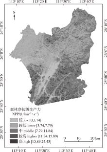
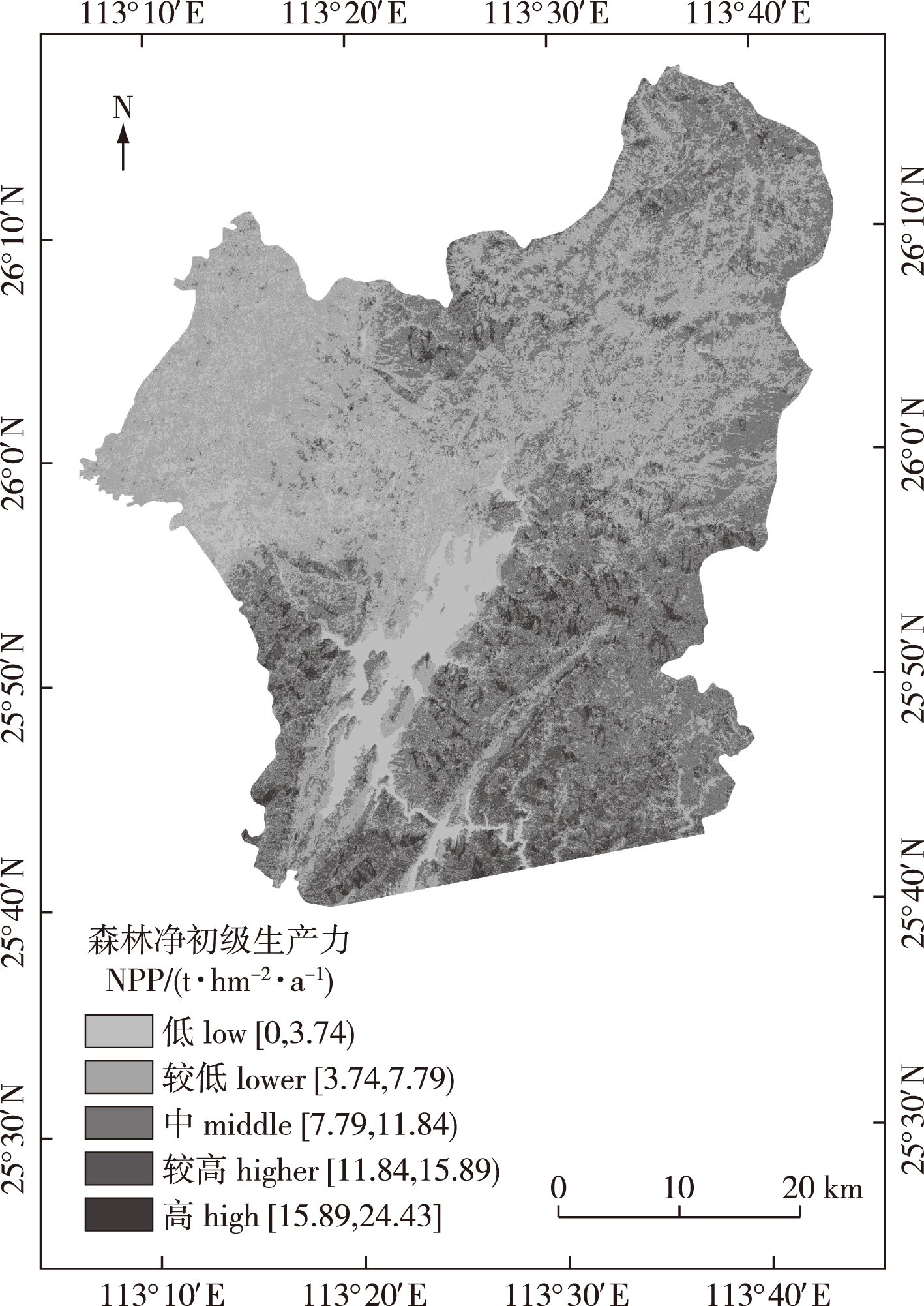
| [1] |
陈利军, 刘高焕, 励惠国. 中国植被净第一性生产力遥感动态监测[J]. 遥感学报, 2002, 6(2):129-135.
|
|
CHEN L J, LIU G H, LI H G. Estimating net primary productivity of’ terrestrial vegetation in China using remote sensing[J]. J Remote Sens, 2002, 6(2):129-135, 164.
|
| [2] |
刘国华, 傅伯杰, 方精云. 中国森林碳动态及其对全球碳平衡的贡献[J]. 生态学报, 2000, 20(5):733-740.
|
|
LIU G H, FU B J, FANG J Y. Carbon dynamics of Chinese forests and its contribution to global carbon balance[J]. Acta Ecol Sin, 2000, 20(5):733-740. DOI: 10.3321/j.issn:1000-0933.2000.05.004.
|
| [3] |
朱文泉, 潘耀忠, 张锦水. 中国陆地植被净初级生产力遥感估算[J]. 植物生态学报, 2007, 31(3):413-424.
|
|
ZHU W Q, PAN Y Z, ZHANG J S. Estimation of net primary productivity of Chinese terrestrial vegetation based on remote sensing[J]. J Plant Ecol, 2007, 31(3):413-424. DOI: 10.17521/cjpe.2007.0050.
|
| [4] |
郭睿妍, 田佳, 杨志玲, 等. 基于GEE平台的黄河流域森林植被净初级生产力时空变化特征[J]. 生态学报, 2022, 42(13):5437-5445.
|
|
GUO R Y, TIAN J, YANG Z L, et al. Spatio-temporal variation characteristics of forest net primary productivity in the Yellow River basin based on Google Earth Engine cloud platform[J]. Acta Ecol Sin, 2022, 42(13):5437-5445. DOI: 10.5846/stxb202104271113.
|
| [5] |
RAFIQUE R, ZHAO F, DE JONG R, et al. Global and regional variability and change in terrestrial ecosystems net primary production and NDVI: a model-data comparison[J]. Remote Sens, 2016, 8(3):177. DOI: 10.3390/rs8030177.
|
| [6] |
SANNIGRAHI S. Modeling terrestrial ecosystem productivity of an estuarine ecosystem in the Sundarban Biosphere region,India using seven ecosystem models[J]. Ecol Model, 2017, 356:73-90. DOI: 10.1016/j.ecolmodel.2017.03.003.
|
| [7] |
林文鹏, 王臣立, 赵敏, 等. 基于森林清查和遥感的城市森林净初级生产力估算[J]. 生态环境, 2008, 17(2):766-770.
|
|
LIN W P, WANG C L, ZHAO M, et al. Estimation urban forests NPP based on forest inventory data and remote sensing[J]. Ecol Environ, 2008, 17(2):766-770. DOI: 10.16258/j.cnki.1674-5906.2008.02.076.
|
| [8] |
TAN K, ZHOU S Y, LI E Z, et al. Assessing the impact of urbanization on net primary productivity using multi-scale remote sensing data: a case study of Xuzhou, China[J]. Front Earth Sci. 2015, 9(2):319-329. DOI: 10.1007/s11707-014-0454-7.
|
| [9] |
REICH P B, TURNER D P, BOLSTAD P. An approach to spatially distributed modeling of net primary production (NPP) at the landscape scale and its application in validation of EOS NPP products[J]. Remote Sens Environ, 1999, 70(1):69-81. DOI: 10.1016/S0034-4257(99)00058-9.
|
| [10] |
SHANG E P, XU E Q, ZHANG H Q, et al. Analysis of spatiotemporal dynamics of the Chinese vegetation net primary productivity from the 1960s to the 2000s[J]. Remote Sens, 2018, 10(6):860. DOI: 10.3390/rs10060860.
|
| [11] |
李陶, 李明阳, 钱春花. 结合冠层密度的森林净初级生产力遥感估测[J]. 南京林业大学学报(自然科学版), 2021, 45(5):153-160.
|
|
LI T, LI M Y, QIAN C H. Combining crown density to estimate forest net primary productivity by using remote sensing data[J]. J Nanjing For Univ (Nat Sci Ed), 2021, 45(5):153-160. DOI: 10.12302/j.issn.1000-2006.202008007.
|
| [12] |
MA H, SONG J L, WANG J D, et al. Comparison of the inversion ability in extrapolating forest canopy height by integration of LiDAR data and different optical remote sensing products[C]// 2012 IEEE International Geoscience and Remote Sensing Symposium.Munich, Germany: IEEE, 2012:3363-3366. DOI: 10.1109/IGARSS.2012.6350700.
|
| [13] |
李登秋. 亚热带森林碳收支变化特征及其成因模拟分析[D]. 南京: 南京大学, 2014.
|
|
LI D Q. Variations of forest carbon budget and underlying driving forces in the subtropical area of China: a case study for Jiangxi Province[D]. Nanjing: Nanjing University, 2014.
|
| [14] |
史瑶. 基于MSPA和MCR模型的资兴市生态网络构建研究[D]. 长沙: 中南林业科技大学, 2019.
|
|
SHI Y. Ecological network construction and research using MSPA and MCR models in Zixing City, Hunan Province, China[D]. Changsha: Central South University of Forestry & Technology, 2019.
|
| [15] |
李轲敏, 傅丽华, 郭湘. 资兴市自然保护地空间冲突与重构研究[J]. 湖南工业大学学报, 2022, 36(2):86-94.
|
|
LI K M, FU L H, GUO X. Research on spatial conflict and reconstruction of protected natural areas in Zixing City[J]. J Hunan Univ Technol, 2022, 36(2):86-94. DOI: 10.3969/j.issn.1673-9833.2022.02.012.
|
| [16] |
余超, 王斌, 刘华, 等. 中国森林植被净生产量及平均生产力动态变化分析[J]. 林业科学研究, 2014, 27(4):542-550.
|
|
YU C, WANG B, LIU H, et al. Dynamic change of net production and mean net primary productivity of China’s forests[J]. For Res, 2014, 27(4):542-550. DOI: 10.13275/j.cnki.lykxyj.2014.04.016.
|
| [17] |
温小荣, 蒋丽秀, 刘磊, 等. 江苏省森林生物量与生产力估算及空间分布格局分析[J]. 西北林学院学报, 2014, 29(1):36-40.
|
|
WEN X R, JIANG L X, LIU L, et al. Estimation of forest biomass, net primary production and analysis on spatial distribution pattern for Jiangsu Province[J]. J Northwest For Univ, 2014, 29(1):36-40. DOI: 10.3969/j.issn.1001-7461.2014.01.07.
|
| [18] |
董佳臣, 倪文俭, 张志玉, 等. ICESat-2植被冠层高度和地表高程数据产品用于森林高度提取的效果评价[J]. 遥感学报, 2021, 25(6):1294-1307.
|
|
DONG J C, NI W J, ZHANG Z Y, et al. Performance of ICESat-2 ATL08 product on the estimation of forest height by referencing to small footprint LiDAR data[J]. Natl Remote Sens Bull, 2021, 25(6):1294-1307. DOI: 10.11834/jrs.202194491.
|
| [19] |
孙美美. 黄土丘陵区三种典型森林类型生产力形成及影响因素[D]. 杨凌: 西北农林科技大学, 2021.
|
|
SUN M M. Net primary productivity and its influencing factors in three typical forest types in the loess hilly region[D]. Yangling: Northwest A&F University, 2021.
|
| [20] |
黄昕. 高分辨率遥感影像多尺度纹理、形状特征提取与面向对象分类研究[D]. 武汉: 武汉大学, 2009.
|
|
HUANG X. Multiscale texture and shape feature extraction and object-oriented classification for very high resolution remotely sensed imagery[D]. Wuhan: Wuhan University, 2009.
|
| [21] |
刘俊, 毕华兴, 朱沛林, 等. 基于ALOS遥感数据纹理及纹理指数的柞树蓄积量估测[J]. 农业机械学报, 2014, 45(7):245-254.
|
|
LIU J, BI H X, ZHU P L, et al. Estimating stand volume of Xylosma racemosum forest based on texture parameters and derivative texture indices of ALOS imagery[J]. Trans Chin Soc Agric Mach, 2014, 45(7):245-254. DOI: 10.6041/j.issn.1000-1298.2014.07.038
|
| [22] |
陈琳. 基于光学和干涉雷达的森林地上生物量遥感估算模型研究[D]. 长春: 中国科学院大学(中国科学院东北地理与农业生态研究所), 2020.
|
|
CHEN L. Modeling of forest aboveground biomass based on optical and interferometric synthetic aperture radar[D]. Changchun: Northeast Institute of Geography and Agroecology, Chinese Academy of Sciences, 2020.
|
| [23] |
KENYI L W, DUBAYAH R, HOFTON M, et al. Comparative analysis of SRTM-NED vegetation canopy height to LIDAR-derived vegetation canopy metrics[J]. Int J Remote Sens, 2009, 30(11):2797-2811. DOI: 10.1080/01431160802555853.
|
| [24] |
NI W J, GUO Z F, SUN G Q, et al. Investigation of forest height Retrieval using SRTM-DEM and ASTER-GDEM[C]// 30th IEEE International Geoscience and Remote Sensing Symposium (IGARSS) on Remote Sensing-Global Vision for Local Action: 20102111- 2114. DOI: 10.1109/IGARSS.2010.5651443.
|
| [25] |
BALLHORN U, JUBANSKI J, SIEGERT F. ICESat/GLAS data as a measurement tool for peatland topography and peat swamp forest biomass in Kalimantan, Indonesia[J]. Remote Sens, 2011, 3(9):1957-1982. DOI: 10.3390/rs3091957.
|
| [26] |
范文义, 张海玉, 于颖, 等. 三种森林生物量估测模型的比较分析[J]. 植物生态学报, 2011, 35(4):402-410.
|
|
FAN W Y, ZHANG H Y, YU Y, et al. Comparison of three models of forest biomass estimation[J]. Chin J Plant Ecol, 2011, 35(4):402-410. DOI: 10.3724/SP.J.1258.2011.00402.
|
| [27] |
陈尔学, 李增元, 武红敢, 等. 基于k-NN和Landsat数据的小面积统计单元森林蓄积估测方法[J]. 林业科学研究, 2008, 21(6):745-750.
|
|
CHEN E X, LI Z Y, WU H G, et al. Forest volume estimation method for small areas based on k-NN and Landsat data[J]. For Res, 2008, 21(6):745-750. DOI: 10.3321/j.issn:1001-1498.2008.06.002.
|
| [28] |
LI T, LI M Y, REN F, et al. Estimation and spatio-temporal change analysis of NPP in subtropical forests: a case study of Shaoguan, Guangdong, China[J]. Remote Sens, 2022, 14(11):2541.DOI: 10.3390/rs14112541.
|
| [29] |
李欣海. 随机森林模型在分类与回归分析中的应用[J]. 应用昆虫学报, 2013, 50(4):1190-1197.
|
|
LI X H. Using “random forest” for classification and regression[J]. Chin J Appl Entomol, 2013, 50(4):1190-1197.DOI: 10.7679/j.issn.2095-1353.2013.163.
|
| [30] |
BOLÓN-CANEDO V, SÁNCHEZ-MAROÑO N, ALONSO-BETANZOS A. Feature selection for high-dimensional data[J]. Prog Artif Intell, 2016, 5(2):65-75.DOI: 10.1007/s13748-015-0080-y.
|
| [31] |
潘磊, 孙玉军, 王轶夫, 等. 基于Sentinel-1和Sentinel-2数据的杉木林地上生物量估算[J]. 南京林业大学学报(自然科学版), 2020, 44(3):149-156.
|
|
PAN L, SUN Y J, WANG Y F, et al. Estimation of aboveground biomass in a Chinese fir(Cunninghamia lanceolata)forest combining data of Sentinel-1 and Sentinel-2[J]. J Nanjing For Univ (Nat Sci Ed), 2020, 44(3):149-156.DOI: 10.3969/j.issn.1000-2006.201811012.
|
| [32] |
SERVIA H, PAREETH S, MICHAILOVSKY C I, et al. Operational framework to predict field level crop biomass using remote sensing and data driven models[J]. Int J Appl Earth Obs Geoinf, 2022, 108:102725.DOI: 10.1016/j.jag.2022.102725.
|
| [33] |
高志强, 刘纪远. 中国植被净生产力的比较研究[J]. 科学通报, 2008, 53(3):317-326.
|
|
GAO Z Q, LIU J Y. Comparative study on net productivity of vegetation in China[J]. Chin Sci Bull, 2008, 53(3):317-326. DOI: 10.1360/csb2008-53-3-317.
|
| [34] |
陈晓玲, 曾永年. 亚热带山地丘陵区植被NPP时空变化及其与气候因子的关系:以湖南省为例[J]. 地理学报, 2016, 71(1):35-48.
|
|
CHEN X L, ZENG Y N. Spatial and temporal variability of the net primary production (NPP) and its relationship with climate factors in subtropical mountainous and hilly regions of China: a case study in Hunan Province[J]. Acta Geogr Sin, 2016, 71(1):35-48.DOI: 10.11821/dlxb201601003.
|
| [35] |
闫妍, 覃金华, 房磊, 等. 湖南省植被净初级生产力时空动态及其与气候因素的关系[J]. 生态学杂志, 2022, 41(8):1535-1544.
|
|
YAN Y, QIN J H, FANG L, et al. Spatiotemporal dynamics of vegetation net primary productivity and its relationships with climatic factors in Hunan Province[J]. Chin J Ecol, 2022, 41(8):1535-1544. DOI: 10.13292/j.1000-4890.202208.015.
|
| [36] |
江源通. 湘江流域植被NPP时空动态及影响因素分析[D]. 湘潭: 湖南科技大学, 2015.
|
|
JIANG Y T. Analysis of spatio-temporal dynamics and factors influencing vegetation NPP in Xiangjiang River basin[D]. Xiangtan: Hunan University of Science and Technology, 2015.
|
| [37] |
张骏. 中国中亚热带东部森林生态系统生产力和碳储量研究[D]. 杭州: 浙江大学, 2008.
|
|
ZHANG J. NPP and carbon storage in subtropical forest,eastern China[D]. Hangzhou: Zhejiang University, 2008.
|

 ), 李明阳*(