| [1] |
WEN Z M, LEES B G, JIAO F, et al. Stratified vegetation cover index:a new way to assess vegetation impact on soil erosion[J]. CATENA, 2010, 83(1):87-93.DOI:10.1016/j.catena.2010.07.006.
|
| [2] |
MARSETT R C, QI J G, HEILMAN P, et al. Remote sensing for grassland management in the arid southwest[J]. Rangel Ecol Manag, 2006, 59(5):530-540.DOI:10.2111/05-201R.1.
|
| [3] |
JIA K, LI Y W, LIANG S L, et al. Combining estimation of green vegetation fraction in an arid region from Landsat 7 ETM+ data[J]. Remote Sens, 2017, 9(11):1121.DOI:10.3390/rs9111121.
|
| [4] |
DE ASIS A M, OMASA K. Estimation of vegetation parameter for modeling soil erosion using linear Spectral Mixture Analysis of Landsat ETM data[J]. ISPRS J Photogramm Remote Sens, 2007, 62(4):309-324.DOI:10.1016/j.isprsjprs.2007.05.013.
|
| [5] |
ROUJEAN J L. Global mapping of vegetation parameters from POLDER multiangular measurements for studies of surface-atmosphere interactions:a pragmatic method and its validation[J]. J Geophys Res, 2002, 107(D12):4150.DOI:10.1029/2001jd000751.
|
| [6] |
张洪达, 赵传普, 戴玉婷, 等. 群落尺度植被水土保持功能评价模型的构建:以大别山北麓安徽省金寨县为例[J]. 水土保持通报, 2022, 42(1):122-129.
|
|
ZHANG H D, ZHAO C P, DAI Y T, et al. Construction of evaluation model for soil and water conservation function of vegetation at community scale-taking Jinzhai County,Anhui Province at northern foot of Dabie Mountains as an example[J]. Bull Soil Water Conserv, 2022, 42(1):122-129.DOI:10.13961/j.cnki.stbctb.2022.01.017.
|
| [7] |
张骁, 赵文武, 刘源鑫. 遥感技术在土壤侵蚀研究中的应用述评[J]. 水土保持通报, 2017, 37(2):228-238.
|
|
ZHANG X, ZHAO W W, LIU Y X. Application of remote sensing technology in research of soil erosion:a review[J]. Bull Soil Water Conserv, 2017, 37(2):228-238.DOI:10.13961/j.cnki.stbctb.2017.02.035.
|
| [8] |
杨翔惟, 张洪达, 刘霞, 等. 面向多源异构数据环境的区域水土流失野外调查技术研究与应用[J]. 干旱区资源与环境, 2020, 34(10):139-146.
|
|
YANG X W, ZHANG H D, LIU X, et al. Research and application of field investigation technology of regional soil and water loss in multi-source heterogeneous data environment[J]. J Arid Land Resour Environ, 2020, 34(10):139-146.DOI:10.13448/j.cnki.jalre.2020.280.
|
| [9] |
邱凤婷, 过志峰, 张宗科, 等. 大湄公河次区域植被覆盖时空变化特征及其与气象因子的关系[J]. 南京林业大学学报(自然科学版), 2022, 46(2): 187-195.
|
|
QIU F T, GUO Z F, ZHANG Z K, et al. Spatio-temporal change characteristics of vegetation coverage and its relationship with meteorological factors in the Greater Mekong Subregion[J]. Journal of Nanjing Forestry University(Natural Sciences Edition), 2022, 46(2):187-195.DOI:10.12302/j.issn.1000-2006.202010020.
|
| [10] |
BOLTON D K, FRIEDL M A. Forecasting crop yield using remotely sensed vegetation indices and crop phenology metrics[J]. Agric For Meteorol, 2013, 173:74-84.DOI:10.1016/j.agrformet.2013.01.007.
|
| [11] |
QI J, MARSETT R C, MORAN M S, et al. Spatial and temporal dynamics of vegetation in the San Pedro River basin area[J]. Agric For Meteorol, 2000, 105(1/2/3):55-68.DOI:10.1016/S0168-1923(00)00195-7.
|
| [12] |
张婧, 刘咏梅, 徐健, 等. 影像分辨率对植被覆盖度提取的影响[J]. 水土保持研究, 2014, 21(3):120-124.
|
|
ZHANG J, LIU Y M, XU J, et al. Scale effect analysis of the extraction about vegetation coverage[J]. Res Soil Water Conserv, 2014, 21(3):120-124.DOI:10.13869/j.cnki.rswc.2014.03.023.
|
| [13] |
MU X H, HUANG S, REN H Z, et al. Validating GEOV1 fractional vegetation cover derived from coarse-resolution remote sensing images over croplands[J]. IEEE J Sel Top Appl Earth Obs Remote Sens, 2015, 8(2):439-446.DOI:10.1109/JSTARS.2014.2342257.
|
| [14] |
TIAN Y H, WOODCOCK C E, WANG Y J, et al. Multiscale analysis and validation of the MODIS LAI product[J]. Remote Sens Environ, 2002, 83(3):414-430.DOI:10.1016/S0034-4257(02)00047-0.
|
| [15] |
LI P, HE Z W, HE D, et al. Fractional vegetation coverage response to climatic factors based on grey relational analysis during the 2000-2017 growing season in Sichuan Province,China[J]. Int J Remote Sens, 2020, 41(3):1170-1190.DOI:10.1080/01431161.2019.1657605.
|
| [16] |
TUCKER C J. Red and photographic infrared linear combinations for monitoring vegetation[J]. Remote Sens Environ, 1979, 8(2):127-150.DOI:10.1016/0034-4257(79)90013-0.
|
| [17] |
中华人民共和国水利部. 土壤侵蚀分类分级标准:SL 190—2007[S]. 北京: 中国水利水电出版社, 2008.
|
|
Ministry of Water Resources of the People’s Republic of China. Standards for classification and gradation of soil erosion:SL 190—2007[S]. Beijing: China Water & Power Press, 2008.
|
| [18] |
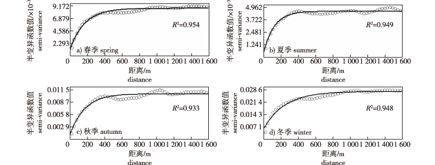
毋亭, 张勇, 侯西勇. 基于半变异函数的环渤海地区NDVI空间格局特征研究[J]. 生态科学, 2014, 33(2):313-320.
|
|
WU T, ZHANG Y, HOU X Y. Analysis of spatial patterns of NDVI over the Circum-Bohai Sea region based on semi-variogram[J]. Ecol Sci, 2014, 33(2):313-320.DOI:10.3969/j.issn.1008-8873.2014.02.018.
|
| [19] |
卫春阳, 徐丹丹, 董凯凯, 等. 遥感影像空间格局变异函数分析研究进展[J]. 地球信息科学学报, 2017, 19(4):540-548.
|
|
WEI C Y, XU D D, DONG K K, et al. Advances in analysis of remote sensing image pattern based on semi-variogram[J]. J Geo Inf Sci, 2017, 19(4):540-548.DOI:10.3969/j.issn.1560-8999.2017.04.012.
|
| [20] |
周静平, 李存军, 胡海棠, 等. 森林植被遥感监测影像最佳分辨率选择[J]. 浙江农林大学学报, 2018, 35(4):716-723.
|
|
ZHOU J P, LI C J, HU H T, et al. Optimal resolution selection for monitoring forest vegetation using remote sensing images[J]. J Zhejiang A F Univ, 2018, 35(4):716-723.DOI:10.11833/j.issn.2095-0756.2018.04.017.
|
| [21] |
ATKINSON P M, CURRAN P J. Defining an optimal size of support for remote sensing investigations[J]. IEEE Trans Geosci Remote Sens, 1995, 33(3):768-776.DOI:10.1109/36.387592.
|
| [22] |
MEISEL J E, TURNER M G. Scale detection in real and artificial landscapes using semivariance analysis[J]. Landsc Ecol, 1998, 13(6):347-362.DOI:10.1023/A:1008065627847.
|
| [23] |
徐岚, 赵羿. 利用马尔柯夫过程预测东陵区土地利用格局的变化[J]. 应用生态学报, 1993, 4(3):272-277.
|
|
XU L, ZHAO Y. Forecast of land use pattern change in Dongling District of Shenyang:an application of Markov process[J]. Chin J Appl Ecol, 1993, 4(3):272-277.
|
| [24] |
鲁春阳, 齐磊刚, 桑超杰. 土地利用变化的数学模型解析[J]. 资源开发与市场, 2007, 23(1):25-27.
|
|
LU C Y, QI L G, SANG C J. Analysis on mathematic model of land-use changes[J]. Resour Dev Mark, 2007, 23(1):25-27.DOI:10.3969/j.issn.1005-8141.2007.01.008.
|
| [25] |
胡鸿, 许延丽, 鞠洪波, 等. 基于遥感影像的福建省长汀县级植被覆盖变化监测及分析[J]. 南京林业大学学报(自然科学版), 2019, 43(3):92-98.
|
|
HU H, XU Y L, JU H B, et al. Monitoring and analysis of county-level vegetation cover change in Changting,Fujian based on remote sensing images[J]. Journal of Nanjing Forestry University(Natural Sciences Edition), 2019, 43(3):92-98.DOI:10.3969/j.issn.1000-2006.201805013.
|
| [26] |
MILNE B T, COHEN W B. Multiscale assessment of binary and continuous landcover variables for MODIS validation,mapping,and modeling applications[J]. Remote Sens Environ, 1999, 70(1):82-98.DOI:10.1016/S0034-4257(99)00059-0.
|
| [27] |
SILVESTRI S, MARANI M, SETTLE J, et al. Salt marsh vegetation radiometry[J]. Remote Sens Environ, 2002, 80(3):473-482.DOI:10.1016/S0034-4257(01)00325-X.
|
| [28] |
江淼, 张显峰, 孙权, 等. 不同分辨率影像反演植被覆盖度的参数确定与尺度效应分析[J]. 武汉大学学报·信息科学版, 2011, 36(3):311-315.
|
|
JIANG M, ZHANG X F, SUN Q, et al. Vegetation coverage retrieval scale effect analysis using multi-sensor data[J]. Geomat Inf Sci Wuhan Univ, 2011, 36(3):311-315.DOI:10.13203/j.whugis2011.03.010.
|
| [29] |
BARET F, HAGOLLE O, GEIGER B, et al. LAI,fAPAR and fCover CYCLOPES global products derived from VEGETATION, Part 1: principles of the algorithm[J]. Remote Sens Environ, 2007, 110(3):275-286.DOI:10.1016/j.rse.2007.02.018.
|

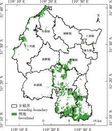
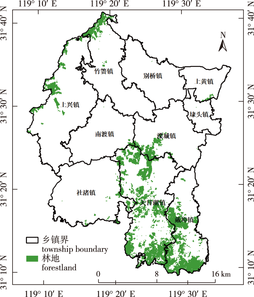
 ), 谭露1, 郭红丽2, 吴芳2, 齐斐3, 蒙雯婷1, 徐雁南1,*(