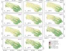
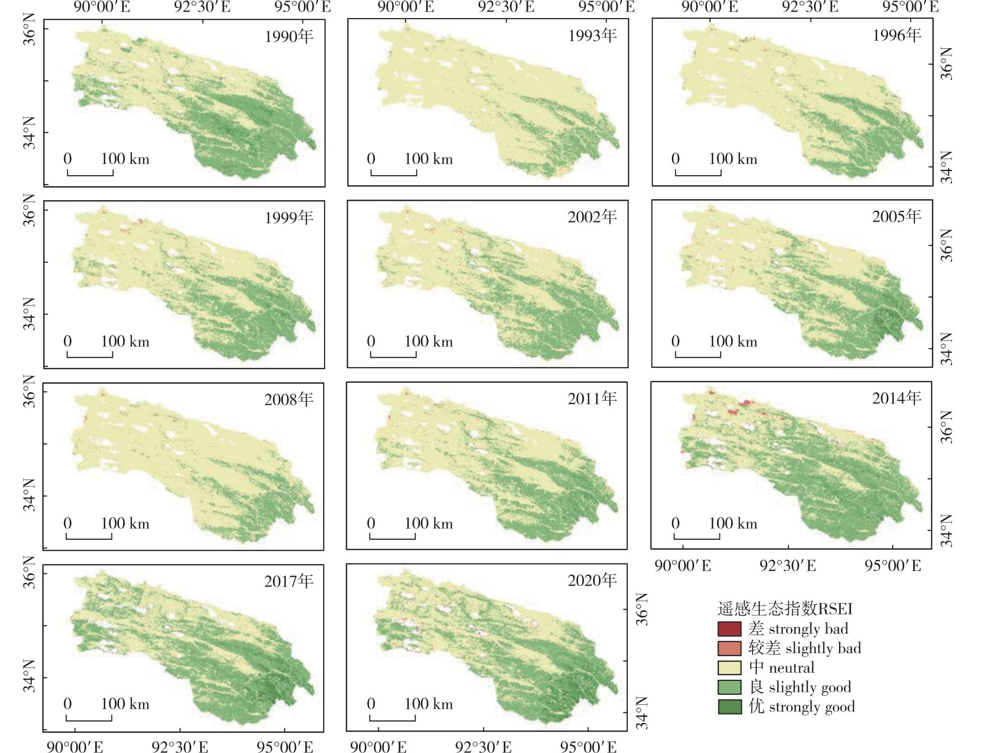
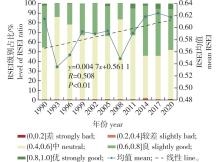
| [1] |
樊江文, 邵全琴, 刘纪远, 等. 1988—2005年三江源草地产草量变化动态分析[J]. 草地学报, 2010, 18(1):5-10.
|
|
FAN J W, SHAO Q Q, LIU J Y, et al. Dynamic changes of grassland yield in Three River Headwater region from 1988 to 2005[J]. Acta Agrestia Sinica, 2010, 18(1):5-10.DOI:10.3969/j.issn.1007-0435.2010.01.002.
|
| [2] |
张彩红, 薛伟, 辛颖, 等. 基于层次分析法的贵州玉舍国家森林公园休养地适宜度评价[J]. 南京林业大学学报(自然科学版), 2020, 44(2):215-219.
|
|
ZHANG C H, XUE W, XIN Y, et al. Suitability evaluation of rest and recuperation sites in Guizhou Yushe National Forest Park by analytic hierarchy process(AHP)[J]. Journal of Nanjing Forestry University (Natural Sciences Edition), 2020, 44(2):215-219.DOI:10.3969/j.issn.1000-2006.201812009.
|
| [3] |
任继周, 林慧龙. 江河源区草地生态建设构想[J]. 草业学报, 2005, 14(2):1-8.
|
|
REN J Z, LIN H L. Assumed plan on grassland ecological reconstruction in the source region of Yangtse River,Yellow River and Lantsang River[J]. Acta Pratacultural Science, 2005, 14(2):1-8.DOI:10.3321/j.issn:1004-5759.2005.02.001.
|
| [4] |
陈兴, 余正勇. 三江源国家公园生态保护研究进展与展望[J]. 国土资源科技管理, 2022, 39(2):13-24.
|
|
CHEN X, YU Z Y. Research progress and prospect of ecological protection in Sanjiang-yuan National Park[J]. Scientific and Technological Management of Land and Resources, 2022, 39(2):13-24.DOI:10.3969/j.issn.1009-4210.2022.02.002.
|
| [5] |
刘栩位, 周启刚, 周浪, 等. 基于RSEI的三峡库区重庆段水土保持生态功能区生态环境质量动态监测[J]. 水土保持研究, 2021, 28(5):278-286.
|
|
LIU X W, ZHOU Q G, ZHOU L, et al. RSEI-based dynamic monitoring of ecological quality of the soil and water conservation functional area in the Chongqing section of the Three Gorges Reservoir area[J]. Research of Soil and Water Conservation, 2021, 28(5):278-286.DOI:10.13869/j.cnki.rswc.2021.05.032.
|
| [6] |
WU S P, GAO X, LEI J Q, et al. Ecological environment quality evaluation of the Sahel region in Africa based on remote sensing ecological index[J]. Journal of Arid Land, 2022, 14(1):14-33.DOI:10.1007/s40333-022-0057-1.
|
| [7] |
徐涵秋. 区域生态环境变化的遥感评价指数[J]. 中国环境科学, 2013, 33(5):889-897.
|
|
XU H Q. A remote sensing index for assessment of regional ecological changes[J]. China Environmental Science, 2013, 33(5):889-897.DOI:10.3969/j.issn.1000-6923.2013.05.019.
|
| [8] |
MATEO-GARCÍA G, GÓME-CHOVA L, AMORÓS-LÓPEZ J, et al. Multitemporal cloud masking in the google earth engine[J]. Remote Sensing, 2018, 10(7):1079.DOI:10.3390/rs10071079.
|
| [9] |
TSAI Y H, STOW D, CHEN H L, et al. Mapping vegetation and land use types in Fanjingshan National Nature Reserve using google earth engine[J]. Remote Sensing, 2018, 10(6):927.DOI:10.3390/rs10060927.
|
| [10] |
李婷婷, 马超, 郭增长. 基于RSEI模型的贺兰山长时序生态质量评价及影响因素分析[J]. 生态学杂志, 2021, 40(4):1154-1165.
|
|
LI T T, MA C, GUO Z C. Ecological quality evaluation and influencing factors analysis of Helan Mountain based on RSEI[J]. Chinese Journal of Ecology, 2021, 40(4):1154-1165.DOI:10.13292/j.1000-4890.202104.027.
|
| [11] |
唐燕文. 基于遥感生态指数的东江源流域生态环境质量评价[D]. 赣州: 江西理工大学, 2021.DOI: 10.27176/d.cnki.gnfyc.2021.000588.
|
|
TANG Y W. Evaluation of ecological environment quality in the source basin of Dongjiang River based on remote sensing ecological index[D]. Ganzhou: Jiangxi University of Science and Technology, 2021.
|
| [12] |
SUN C J, LI X M, ZHANG W Q, et al. Evolution of ecological security in the tableland region of the Chinese Loess Plateau using a remote-sensing-based index[J]. Sustainability, 2020, 12(8):3489.DOI:10.3390/su12083489.
|
| [13] |
叶有华, 梁永贤, 沈一青, 等. 《生态环境状况评价技术规范(试行)》中若干值得商榷的问题[J]. 热带地理, 2009, 29(4):404-406.
|
|
YE Y H, LIANG Y X, SHEN Y Q, et al. Some issues related to “Technical criterion for eco-environmental status evaluation (trial implementation)”[J].Tropical Geography, 2009, 29(4):404-406.DOI:10.3969/j.issn.1001-5221.2009.04.019.
|
| [14] |
陈炜, 黄慧萍, 田亦陈, 等. 基于Google Earth Engine平台的三江源地区生态环境质量动态监测与分析[J]. 地球信息科学学报, 2019, 21(9):1382-1391.
|
|
CHEN W, HUANG H P, TIAN Y C, et al. Monitoring and assessment of the eco-environment quality in the Sanjiangyuan region based on google earth engine[J]. Journal of Geo-Information Science, 2019, 21(9):1382-1391.
|
| [15] |
赵慧芳, 曹晓云. 三江源国家公园植被覆盖时空变化及其气候驱动因素[J]. 高原气象, 2022, 41(2):328-337.
|
|
ZHAO H F, CAO X Y. Vegetation cover changes and its climate driving in Three-River-Source National Park[J]. Plateau Meteorology, 2022, 41(2):328-337.DOI:10.7522/j.issn.1000-0534.2021.00091.
|
| [16] |
许茜, 李奇, 陈懂懂, 等. 近40 a三江源地区土地利用变化动态分析及预测[J]. 干旱区研究, 2018, 35(3):695-704.
|
|
XU Q, LI Q, CHEN D D, et al. Land use change in the Three-River Headwaters in recent 40 years[J]. Arid Zone Research, 2018, 35(3):695-704.DOI:10.13866/j.azr.2018.03.24.
|
| [17] |
李璠, 颜亮东, 赵梦凡, 等. 三江源地区生长季降水特征对土壤水分的影响[J]. 干旱区资源与环境, 2022, 36(6):121-128.
|
|
LI F, YAN L D, ZHAO M F, et al. Effect of precipitation in growing season on soil moisture in the Sanjiangyuan region[J]. Journal of Arid Land Resources and Environment, 2022, 36(6):121-128.DOI:10.13448/j.cnki.jalre.2022.155.
|
| [18] |
张妹婷, 翟永洪, 张志军, 等. 三江源区草地生态系统质量及其动态变化[J]. 环境科学研究, 2017, 30(1):75-81.
|
|
ZHANG M T, ZHAI Y H, ZHANG Z J, et al. Quality and dynamic changes of grassland ecosystems in the Three-River Headwater region[J]. Research of Environmental Sciences, 2017, 30(1):75-81.DOI:10.13198/j.issn.1001-6929.2017.01.48.
|
| [19] |
WEN X L, MING Y L, GAO Y G, et al. Dynamic monitoring and analysis of ecological quality of Pingtan comprehensive experimental zone,a new type of sea island city,based on RSEI[J]. Sustai-nability, 2020, 12(1):21.DOI:10.3390/su12010021.
|
| [20] |
李洪果, 陈达镇, 许靖诗, 等. 濒危植物格木天然种群的表型多样性及变异[J]. 林业科学, 2019, 55(4):69-83.
|
|
LI H G, CHEN D Z, XU J S, et al. Phenotypic diversity and variation in natural populations of Erythrophleum fordii,an endangered plant species[J]. Scientia Silvae Sinicae, 2019, 55(4):69-83.DOI:10.11707/j.1001-7488.20190408.
|
| [21] |
黄晓军, 祁明月, 李艳雨, 等. 关中地区PM2.5时空演化及人口暴露风险[J]. 环境科学, 2020, 41(12):5245-5255.
|
|
HUANG X J, QI M Y, LI Y Y, et al. Spatio-temporal evolution and population exposure risk to PM2.5 in the Guanzhong area[J]. Environmental Science, 2020, 41(12):5245-5255.DOI:10.13227/j.hjkx.202004189.
|
| [22] |
TONG S Q, ZHANG J Q, BAO Y H, et al. Analyzing vegetation dynamic trend on the Mongolian Plateau based on the Hurst exponent and influencing factors from 1982-2013[J]. Journal of Geographical Sciences, 2018, 28(5):595-610.DOI:10.1007/s11442-018-1493-x.
|
| [23] |
徐嘉昕, 房世波, 张廷斌, 等. 2000—2016年三江源区植被生长季NDVI变化及其对气候因子的响应[J]. 国土资源遥感, 2020, 32(1):237-246.
|
|
XU J X, FANG S B, ZHANG T B, et al. NDVI changes and its correlation with climate factors of the Three River-Headwater region in growing seasons during 2000 to 2016[J]. Remote Sensing for Land & Resources, 2020, 32(1):237-246.DOI:10.6046/gtzyyg.2020.01.32.
|
| [24] |
周侃, 张健, 虞虎, 等. 国家公园及周边地区人为扰动强度的时空变化与驱动因素:以三江源国家公园为例[J]. 生态学报, 2022, 42(14):5574-5585.
|
|
ZHOU K, ZHANG J, YU H, et al. Spatio-temporal variation and drivers of degree of human distur-bance in National Park and surrounding areas:a case study of Sanjiangyuan National Park[J]. Acta Ecologica Sinica, 2022, 42(14):5574-5585.DOI:10.5846/stxb202106131573.
|
| [25] |
桑国庆, 唐志光, 邓刚, 等. 基于MODIS NDVI时序数据的湖南省植被变化研究[J]. 长江流域资源与环境, 2021, 30(5):1100-1109.
|
|
SANG G Q, TANG Z G, DENG G, et al. Study on ve-getation change in Hunan Province based on MODIS NDVI time series data[J]. Resources and Environment in the Yangtze Basin, 2021, 30(5):1100-1109.DOI:10.11870/cjlyzyyhj202105007.
|
| [26] |
徐丽娇, 胡泽勇, 赵亚楠, 等. 1961—2010年青藏高原气候变化特征分析[J]. 高原气象, 2019, 38(5):911-919.
|
|
XU L J, HU Z Y, ZHAO Y N, et al. Climate change characteristics in Qinghai-Tibetan Plateau during 1961-2010[J]. Plateau Meteorology, 2019, 38(5):911-919.DOI:10.7522/j.issn.1000-0534.2018.00137.
|
| [27] |
卢明星, 徐传红, 朱咏莉, 等. Cd诱导土壤ALP的Hormesis效应:土地利用变化的驱动机制[J]. 南京林业大学学报(自然科学版), 2020, 44(2):173-180.
|
|
LU M X, XU C H, ZHU Y L, et al. Hormetic effect of Cd on soil alkaline phosphatase:driving mechanism of land use change[J]. Journal of Nanjing Forestry University (Natural Sciences Edition), 2020, 44(2):173-180.DOI:10.3969/j.issn.1000-2006.201903054.
|
| [28] |
YANG X Y, MENG F, FU P J, et al. Spatiotemporal change and driving factors of the eco-environment quality in the Yangtze River Basin from 2001 to 2019[J]. Ecological Indicators, 2021,131:108214.DOI:10.1016/j.ecolind.2021.108214.
|
| [29] |
赵风华, 于贵瑞. 陆地生态系统碳-水耦合机制初探[J]. 地理科学进展, 2008, 27(1):32-38.
|
|
ZHAO F H, YU G R. A review on the coupled carbon and water cycles in the terrestrial ecosystems[J]. Progress in Geography, 2008, 27(1):32-38.DOI:10.11820/dlkxjz.2008.01.005.
|

 ), 蒋馥根, 龙依, 邓目丽, 孙华*(