Tree species identification of combined TLS date and UAV images

ZHONG Hao, WANG Chuhong, LIN Wenshu

JOURNAL OF NANJING FORESTRY UNIVERSITY ›› 2024, Vol. 48 ›› Issue (4) : 104-112.

PDF(3331 KB)
PDF(3331 KB)
JOURNAL OF NANJING FORESTRY UNIVERSITY ›› 2024, Vol. 48 ›› Issue (4) : 104-112. DOI: 10.12302/j.issn.1000-2006.202205041

Tree species identification of combined TLS date and UAV images

Author information +
History +

Abstract

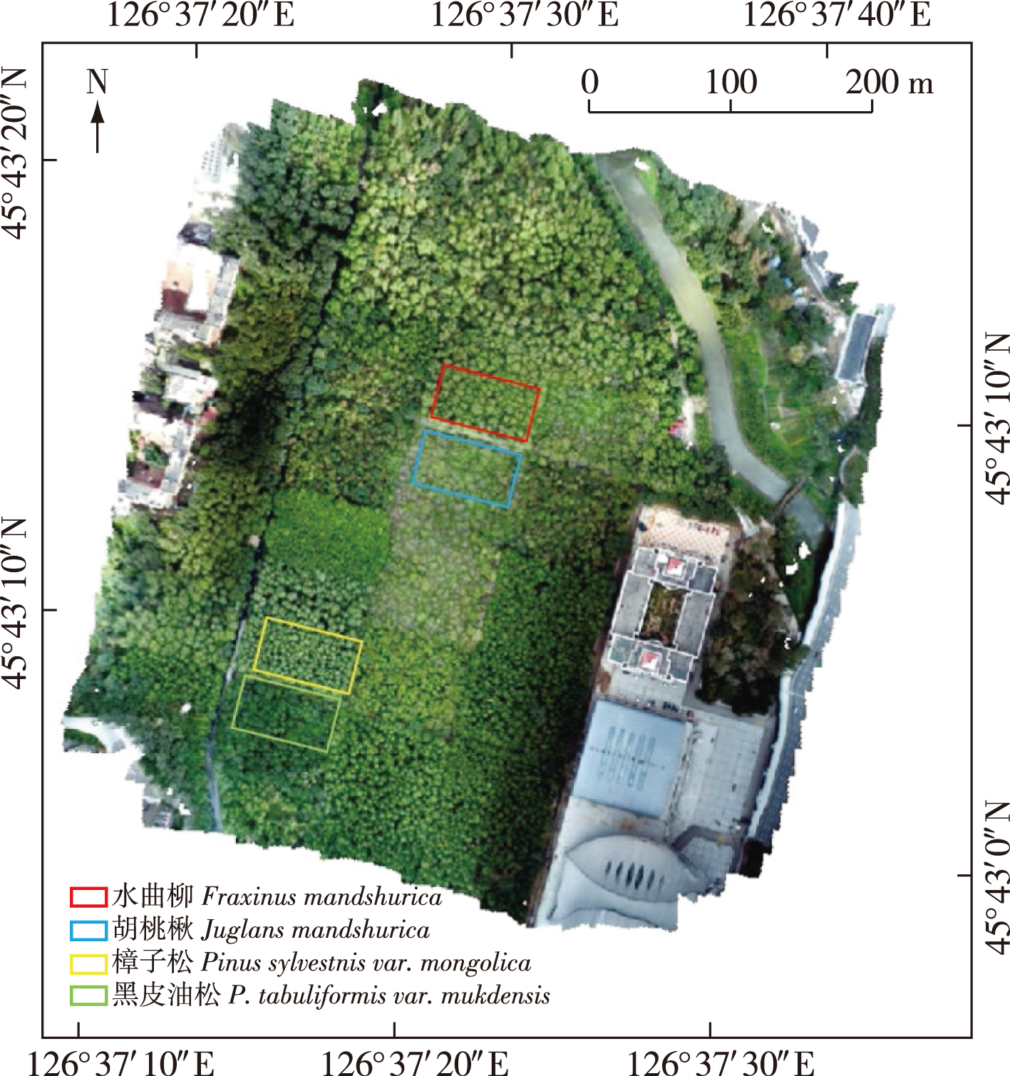
【Objective】Rapid and accurate identification of tree species is crucial for the research and protection of forest resources. Identification of tree species by remote sensing technology has become an important method of forest investigation. However, there are some problems in tree species identification by remote sensing, such as a lack of information in the upper canopy of terrestrial laser scanning (TLS) data and the lower canopy of unmanned aerial vehicle (UAV) images. Therefore, identifying tree species requires multi-source remote sensing data.【Method】In this study, Pinus sylvestris var. mongolica, P. tabuliformis var. mukdensis, Fraxinus mandshurica and Juglans mandshurica in the urban forestry demonstration base of Northeast Forestry University at Harbin were used as the research objects to identify tree species. TLS point cloud data and UAV image data were acquired. Through the processing of UAV images, the photogrammetric point cloud and orthophoto image were obtained. The UAV image point cloud and TLS point cloud data were registered and fused, then divided into single tree points. Based on the single tree point cloud, shape features, structure features, tree trunk color features, and crown color features were extracted, and tree species identification was performed by a support vector machine classification algorithm. Subsequently, the ability of the method to identify tree species using different characteristics was analyzed by random forest algorithm.【Result】Optimal results were obtained when all the features were used to identify tree species. The total accuracy and Kappa coefficient of tree species identification results were 93.48% and 0.91, respectively, which were improved by 4.35-16.31percentage points and 0.06-0.22, respectively, compared with other comparison schemes.【Conclusion】The tree species recognition method based on the fusion of TLS data and UAV image point cloud data proposed in this study can compensate for the lack of information in the upper canopy of TLS point cloud data and the lower canopy of UAV images to a certain extent, and make full use of the rich information contained in multi-source data for tree species recognition. The method can effectively improve the accuracy of tree species identification.
Key words

tree species identification / multi-source remote sensing / LiDAR / unmanned aerial rehicle (UAV) images

Cite this article

Download Citations
ZHONG Hao , WANG Chuhong , LIN Wenshu. Tree species identification of combined TLS date and UAV images[J]. JOURNAL OF NANJING FORESTRY UNIVERSITY. 2024, 48(4): 104-112 https://doi.org/10.12302/j.issn.1000-2006.202205041

References

[1]
LATIFI H, HEURICH M. Multi-scale remote sensing-assisted forest inventory:a glimpse of the state-of-the-art and future prospects[J]. Remote Sens, 2019, 11(11):1260.DOI: 10.3390/rs11111260.
[2]
WHITE J C, COOPS N C, WULDER M A, et al. Remote sensing technologies for enhancing forest inventories:a review[J]. Can J Remote Sens, 2016, 42(5):619-641.DOI: 10.1080/07038992.2016.1207484.
[3]
李增元, 陈尔学. 中国林业遥感发展历程[J]. 遥感学报, 2021, 25(1):292-301.
LI Z Y, CHEN E X. Development course of forestry remote sensing in China[J]. Natl Remote Sens Bull, 2021, 25(1):292-301.
[4]
FENG B K, ZHENG C, ZHANG W Q, et al. Analyzing the role of spatial features when cooperating hyperspectral and LiDAR data for the tree species classification in a subtropical plantation forest area[J]. JARS, 2020, 14(2):022213.DOI: 10.1117/1.JRS.14.022213.
[5]
曹林, 佘光辉, 代劲松, 等. 激光雷达技术估测森林生物量的研究现状及展望[J]. 南京林业大学学报(自然科学版), 2013, 37(3):163-169.
CAO L, SHE G H, DAI J S, et al. Status and prospects of the LiDAR-based forest biomass estimation[J]. J Nanjing For Univ (Nat Sci Ed), 2013, 37(3):163-169.DOI: 10.3969/j.issn.1000-2006.2013.03.029.
[6]
WANG K P, WANG T J, LIU X H. A review:individual tree species classification using integrated airborne LiDAR and optical imagery with a focus on the urban environment[J]. Forests, 2018, 10(1):1.DOI: 10.3390/f10010001.
[7]
黄华国. 林业定量遥感研究进展和展望[J]. 北京林业大学学报, 2019, 41(12):1-14.
HUANG H G. Progress and perspective of quantitative remote sensing of forestry[J]. J Beijing For Univ, 2019, 41(12):1-14.DOI: 10.12171/j.1000-1522.20190326.
[8]
ASNER G P, MASCARO J, MULLER-LANDAU H C, et al. A universal airborne LiDAR approach for tropical forest carbon mapping[J]. Oecologia, 2012, 168(4):1147-1160.DOI: 10.1007/s00442-011-2165-z.
[9]
DIAN Y Y, PANG Y, DONG Y F, et al. Urban tree species mapping using airborne LiDAR and hyperspectral data[J]. J Indian Soc Remote Sens, 2016, 44(4):595-603.DOI: 10.1007/s12524-015-0543-4.
[10]
MAN Q X, DONG P L, YANG X M, et al. Automatic extraction of grasses and individual trees in urban areas based on airborne hyperspectral and LiDAR data[J]. Remote Sens, 2020, 12(17):2725.DOI: 10.3390/rs12172725.
[11]
WALLACE L, LUCIEER A, WATSON C, et al. Development of a UAV-LiDAR system with application to forest inventory[J]. Remote Sens, 2012, 4(6):1519-1543.DOI: 10.3390/rs4061519.
[12]
WALLACE L, MUSK R, LUCIEER A. An assessment of the repeatability of automatic forest inventory metrics derived from UAV-borne laser scanning data[J]. IEEE Trans Geosci Remote Sens, 2014, 52(11):7160-7169.DOI: 10.1109/TGRS.2014.2308208.
[13]
刘清旺, 李世明, 李增元, 等. 无人机激光雷达与摄影测量林业应用研究进展[J]. 林业科学, 2017, 53(7):134-148.
LIU Q W, LI S M, LI Z Y, et al. Review on the applications of UAV-based LiDAR and photogrammetry in forestry[J]. Sci Silvae Sin, 2017, 53(7):134-148.DOI: 10.11707/j.1001-7488.20170714.
[14]
MICHEZ A, PIÉGAY H, JONATHAN L, et al. Mapping of riparian invasive species with supervised classification of Unmanned Aerial System (UAS) imagery[J]. Int J Appl Earth Obs Geoinf, 2016, 44:88-94.DOI: 10.1016/j.jag.2015.06.014.
[15]
陈向宇, 云挺, 薛联凤, 等. 基于激光雷达点云数据的树种分类[J]. 激光与光电子学进展, 2019, 56(12):203-214.
CHEN X Y, YUN T, XUE L F, et al. Classification of tree species based on LiDAR point cloud data[J]. Laser Optoelectron Prog, 2019, 56(12):203-214.DOI: 10.3788/LOP56.122801.
[16]
GUAN H Y, YU Y T, JI Z, et al. Deep learning-based tree classification using mobile LiDAR data[J]. Remote Sens Lett, 2015, 6(11):864-873.DOI: 10.1080/2150704x.2015.1088668.
[17]
廖小罕, 肖青, 张颢. 无人机遥感:大众化与拓展应用发展趋势[J]. 遥感学报, 2019, 23(6):1046-1052.
LIAO X H, XIAO Q, ZHANG H. UAV remote sensing:popularization and expand application development trend[J]. J Remote Sens, 2019, 23(6):1046-1052.
[18]
FRANKLIN S E, AHMED O S. Deciduous tree species classification using object-based analysis and machine learning with unmanned aerial vehicle multispectral data[J]. Int J Remote Sens, 2018, 39(15/16):5236-5245.DOI: 10.1080/01431161.2017.1363442.
[19]
FENG X X, LI P J. A tree species mapping method from UAV images over urban area using similarity in tree-crown object histograms[J]. Remote Sens, 2019, 11(17):1982.DOI: 10.3390/rs11171982.
[20]
SAARINEN N, VASTARANTA M, NÄSI R, et al. Assessing biodiversity in boreal forests with UAV-based photogrammetric point clouds and hyperspectral imaging[J]. Remote Sens, 2018, 10(2):338.DOI: 10.3390/rs10020338.
[21]
ŠAŠAK J, GALLAY M, KANUK J, et al. Combined use of terrestrial laser scanning and UAV photogrammetry in mapping alpine terrain[J]. Remote Sens, 2019, 11(18):2154.DOI: 10.3390/rs11182154.
[22]
TONG X H, LIU X F, CHEN P, et al. Integration of UAV-based photogrammetry and terrestrial laser scanning for the three-dimensional mapping and monitoring of open-pit mine areas[J]. Remote Sens, 2015, 7(6):6635-6662.DOI: 10.3390/rs70606635.
[23]
ROŞCA S, SUOMALAINEN J, BARTHOLOMEUS H, et al. Comparing terrestrial laser scanning and unmanned aerial vehicle structure from motion to assess top of canopy structure in tropical forests[J]. Interface Focus, 2018, 8(2):20170038.DOI: 10.1098/rsfs.2017.0038.
[24]
张吴明, 李丹, 陈一铭, 等. 联合地基激光雷达与无人机摄影测量技术提取树高研究[J]. 北京师范大学学报(自然科学版), 2018, 54(6):764-771.
ZHANG W M, LI D, CHEN Y M, et al. Integration between TLS and UAV photogrammetry techniques for retrieving tree height[J]. J Beijing Norm Univ (Nat Sci), 2018, 54(6):764-771.DOI: 10.16360/j.cnki.jbnuns.2018.06.011.
[25]
曹明兰, 李亚东, 冯海英, 等. 倾斜摄影与激光扫描技术结合的3D森林景观建模[J]. 中南林业科技大学学报, 2019, 39(12):10-15,33.
CAO M L, LI Y D, FENG H Y, et al. 3D forest landscape modeling with the combination of oblique photography and laser scanner technique[J]. J Cent South Univ For Technol, 2019, 39(12):10-15,33.DOI: 10.14067/j.cnki.1673-923x.2019.12.002.
[26]
王楚虹, 刘浩然, 钟浩, 等. 联合UAV-LiDAR和HMLS技术的森林样地点云数据融合[J]. 中南林业科技大学学报, 2022, 42(3):26-38.
WANG C H, LIU H R, ZHONG H, et al. Point cloud data fusion of forest plots based on UAV-LiDAR and HMLS technologies[J]. J Cent South Univ For Technol, 2022, 42(3):26-38.DOI: 10.14067/j.cnki.1673-923x.2022.03.004.
[27]
黎华, 凯吾沙·塔依尔, 林木森, 等. 改进拟牛顿算法的点云稠密化应用研究[J]. 测绘科学, 2021, 46(12):83-90.
LI H, Kai Wusha·Tayier, LIN M S, et al. Research on application of improved Quasi-Newton algorithm in point cloud densification[J]. Sci Surv Mapp, 2021, 46(12):83-90.DOI: 10.16251/j.cnki.1009-2307.2021.12.012.
[28]
TAO S L, WU F F, GUO Q H, et al. Segmenting tree crowns from terrestrial and mobile LiDAR data by exploring ecological theories[J]. ISPRS J Photogramm Remote Sens, 2015, 110:66-76.DOI: 10.1016/j.isprsjprs.2015.10.007.
[29]
ZHANG Z Y, LIU X Y. Support vector machines for tree species identification using LiDAR-derived structure and intensity variables[J]. Geocarto Int, 2013, 28(4):364-378.DOI: 10.1080/10106049.2012.710653.
[30]
ZIEGLER A, KÖNIG I R. Mining data with random forests:current options for real-world applications[J]. Wiley Interdiscip Rev Data Min Knowl Discov, 2014, 4(1):55-63.DOI: 10.1002/widm.1114.
[31]
杨龙, 孙中宇, 唐光良, 等. 基于微型无人机遥感的亚热带林冠物种识别[J]. 热带地理, 2016, 36(5):833-839.
YANG L, SUN Z Y, TANG G L, et al. Identifying canopy species of subtropical forest by lightweight unmanned aerial vehicle remote sensing[J]. Trop Geogr, 2016, 36(5):833-839.DOI: 10.13284/j.cnki.rddl.002857.
[32]
杜培军, 夏俊士, 薛朝辉, 等. 高光谱遥感影像分类研究进展[J]. 遥感学报, 2016, 20(2):236-256.
DU P J, XIA J S, XUE Z H, et al. Review of hyperspectral remote sensing image classification[J]. J Remote Sens, 2016, 20(2):236-256.DOI: 10.11834/jrs.20165022.
[33]
童庆禧, 张兵, 张立福. 中国高光谱遥感的前沿进展[J]. 遥感学报, 2016, 20(5):689-707.
TONG Q X, ZHANG B, ZHANG L F. Current progress of hyperspectral remote sensing in China[J]. J Remote Sens, 2016, 20(5):689-707.DOI: 10.11834/jrs.20166264.
[34]
ZHONG H, LIN W S, LIU H R, et al. Identification of tree species based on the fusion of UAV hyperspectral image and LiDAR data in a coniferous and broad-leaved mixed forest in northeast China[J]. Front Plant Sci, 2022, 13:964769.DOI: 10.3389/fpls.2022.964769.
[35]
刘嘉政, 王雪峰, 王甜. 基于深度学习的树种图像自动识别[J]. 南京林业大学学报(自然科学版), 2020, 44(1):138-144.
LIU J Z, WANG X F, WANG T. Automatic identification of tree species based on deep learning[J]. J Nanjing For Univ (Nat Sci Ed), 2020, 44(1):138-144.DOI: 10.3969/j.issn.1000-2006.201809004.
PDF(3331 KB)

Accesses

Citation

Detail

Sections
Recommended
The full text is translated into English by AI, aiming to facilitate reading and comprehension. The core content is subject to the explanation in Chinese.

/