Research on TLS single tree detection method based on point cloud slicing combined with clustering algorithm

YI Jing, MA Kaisen, XIANG Jianping, TANG Jie, JIANG Fugen, CHEN Song, SUN Hua

JOURNAL OF NANJING FORESTRY UNIVERSITY ›› 2024, Vol. 48 ›› Issue (4) : 113-122.

PDF(2610 KB)
PDF(2610 KB)
JOURNAL OF NANJING FORESTRY UNIVERSITY ›› 2024, Vol. 48 ›› Issue (4) : 113-122. DOI: 10.12302/j.issn.1000-2006.202206035

Research on TLS single tree detection method based on point cloud slicing combined with clustering algorithm

Author information +
History +

Abstract

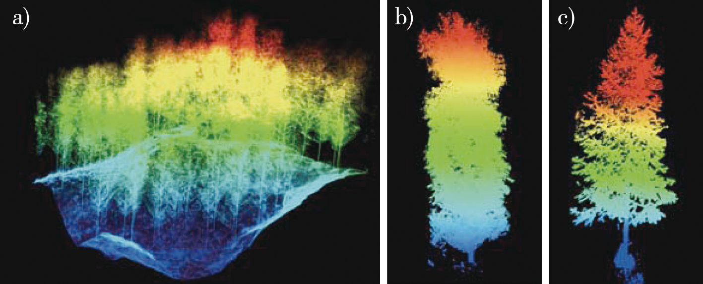
【Objective】To solve the problem that a canopy height model (CHM) and normalized point cloud (NPC) directly generated by terrestrial laser scanning (TLS) are not capable of detecting individual trees in complex stands, this study introduced the method of point cloud slicing combined with clustering to improve the detection accuracy.【Method】In this study, six sample plots in a plantation with different stand densities in Guangxi Zhuang Autonomous Region, China, were used as the research objects. First, the NPC data of a sample plot obtained by TLS were used to extract point cloud slices at a height of 1.3 m, and then the density-based spatial clustering of applications with noise (DBSCAN) and mean shift algorithms were used to cluster the tree trunk point clouds in the slices. The accuracy was verified by the field survey data, and the detection results were compared with those of the local maximum algorithm based on a CHM, and a point cloud segmentation algorithm based on an NPC. The applicability and parameter sensitivity of the different detection methods were evaluated and analyzed.【Result】Satisfactory detection results were obtained by all methods, and the optimal detection accuracy F-score was ≥ 0.86 for each sample plot. The individual tree detection method using point cloud slicing combined with a clustering algorithm produced better results. The clustering threshold epsilon neighborhood (Eps) value of the DBSCAN algorithm and the clustering radius r of the mean shift algorithm significantly affected the individual tree detection rate, with the maximum Eps depending on the maximum stand spacing and optimum results when r was close to the maximum individual tree diameter at breast height.【Conclusion】Individual tree detection based on point cloud slicing combined with a clustering algorithm can increase the detection rate of understory trees lower forest, effectively improve the accuracy of single tree detection in dense stands, and provide a reference for the selection of single tree detection methods in different forest stands.

Key words

terrestrial laser scanning / single tree detection / point cloud slicing / clustering algorithm / extraction of forest parameters / plantation

Cite this article

Download Citations
YI Jing , MA Kaisen , XIANG Jianping , et al . Research on TLS single tree detection method based on point cloud slicing combined with clustering algorithm[J]. JOURNAL OF NANJING FORESTRY UNIVERSITY. 2024, 48(4): 113-122 https://doi.org/10.12302/j.issn.1000-2006.202206035

References

[1]
曹林, 佘光辉, 代劲松, 等. 激光雷达技术估测森林生物量的研究现状及展望[J]. 南京林业大学学报(自然科学版), 2013, 37(3):163-169.
CAO L, SHE G H, DAI J S, et al. Status and prospects of the LiDAR-based forest biomass estimation[J]. J Nanjing For Univ (Nat Sci Ed), 2013, 37(3):163-169.DOI: 10.3969/j.issn.1000-2006.2013.03.029.
[2]
李增元, 刘清旺, 庞勇. 激光雷达森林参数反演研究进展[J]. 遥感学报, 2016, 20(5):1138-1150.
LI Z Y, LIU Q W, PANG Y. Review on forest parameters inversion using LiDAR[J]. J Remote Sens, 2016, 20(5):1138-1150.DOI: 10.11834/jrs.20165130.
[3]
吴楠, 李增元, 廖声熙, 等. 国内外林业遥感应用研究概况与展望[J]. 世界林业研究, 2017, 30(6):34-40.
WU N, LI Z Y, LIAO S X, et al. Current situation and prospect of research on application of remote sensing to forestry[J]. World For Res, 2017, 30(6):34-40.DOI: 10.13348/j.cnki.sjlyyj.2017.0075.y.
[4]
刘鲁霞, 庞勇. 机载激光雷达和地基激光雷达林业应用现状[J]. 世界林业研究, 2014, 27(1):49-56.
LIU L X, PANG Y. Applications of airborne laser scanning and terrestrial laser scanning to forestry[J]. World For Res, 2014, 27(1):49-56.DOI: 10.13348/j.cnki.sjlyyj.2014.01.009.
[5]
花伟成, 田佳榕, 孙心雨, 等. 基于TLS数据的杨树削度方程建立及材积估算[J]. 南京林业大学学报(自然科学版), 2021, 45(4):41-48.
HUA W C, TIAN J R, SUN X Y, et al. Assessing the stem taper function and volume estimation of poplar (Populus)by terrestrial laser scanning[J]. J Nanjing For Univ (Nat Sci Ed), 2021, 45(4):41-48.DOI: 10.12302/j.issn.1000-2006.202006023.
[6]
蒋佳文, 温小荣, 顾海波, 等. 基于多站扫描的点云特征参数与材积结构动态分析[J]. 南京林业大学学报(自然科学版), 2019, 43(6):83-90.
JIANG J W, WEN X R, GU H B, et al. Dynamic analysis of point cloud characteristic parameters and volume structure based on multi-station scan[J]. J Nanjing For Univ (Nat Sci Ed), 2019, 43(6):83-90.DOI: 10.3969/j.issn.1000-2006.201901020.
[7]
XU D D, WANG H B, XU W X, et al. LiDAR applications to estimate forest biomass at individual tree scale:opportunities,challenges and future perspectives[J]. Forests, 2021, 12(5):550.DOI: 10.3390/f12050550.
[8]
刘会玲, 张晓丽, 张莹, 等. 机载激光雷达单木识别研究进展[J]. 激光与光电子学进展, 2018, 55(8):40-48.
LIU H L, ZHANG X L, ZHANG Y, et al. Review on individual tree detection based on airborne LiDAR[J]. Laser Optoelectron Prog, 2018, 55(8):40-48.DOI: 10.3788/LOP55.082805.
[9]
WANG L, GONG P, BIGING G S. Individual tree-crown delineation and treetop detection in high-spatial-resolution aerial imagery[J]. Photogramm Eng Remote Sensing, 2004, 70(3):351-357.DOI: 10.14358/pers.70.3.351.
[10]
刘方舟, 刘浩, 云挺. 基于分水岭优化思想的单木信息分割算法[J]. 林业工程学报, 2020, 5(5):109-116.
LIU F Z, LIU H, YUN T. Individual tree crown separation using the improved watershed method[J]. J For Eng, 2020, 5(5):109-116.DOI: 10.13360/j.issn.2096-1359.202001021.
[11]
郭庆华, 刘瑾, 陶胜利, 等. 激光雷达在森林生态系统监测模拟中的应用现状与展望[J]. 科学通报, 2014, 59(6):459-478.
GUO Q H, LIU J, TAO S L, et al. Perspectives and prospects of LiDAR in forest ecosystem monitoring and modeling[J]. Chin Sci Bull, 2014, 59(6):459-478.DOI: 10.1360/972013-592.
[12]
LI W K, GUO Q H, JAKUBOWSKI M K, et al. A new method for segmenting individual trees from the lidar point cloud[J]. Photogramm Eng Remote Sensing, 2012, 78(1):75-84.DOI: 10.14358/pers.78.1.75.
[13]
LIANG X L, KANKARE V, HYYPPÄ J, et al. Terrestrial laser scanning in forest inventories[J]. ISPRS J Photogramm Remote Sens, 2016, 115:63-77.DOI: 10.1016/j.isprsjprs.2016.01.006.
[14]
LU X C, GUO Q H, LI W K, et al. A bottom-up approach to segment individual deciduous trees using leaf-off lidar point cloud data[J]. ISPRS J Photogramm Remote Sens, 2014, 94:1-12.DOI: 10.1016/j.isprsjprs.2014.03.014.
[15]
CHEN W, HU X B, CHEN W, et al. Airborne LiDAR remote sensing for individual tree forest inventory using trunk detection-aided mean shift clustering techniques[J]. Remote Sens, 2018, 10(7):1078.DOI: 10.3390/rs10071078.
[16]
MADHULATHA T S. An overview on clustering methods[J]. IOSR J Eng, 2012, 2(4):719-725.DOI: 10.9790/3021-0204719725.
[17]
林秀云, 孙圆, 刘晨曦, 等. 依据地面激光扫描数据的杉木材积建模与造材[J]. 东北林业大学学报, 2022, 50(1):33-39.
LIN X Y, SUN Y, LIU C X, et al. Volume modeling and merchantable volume for Cunninghamia lanceolata using terrestrial laser scanner[J]. J Northeast For Univ, 2022, 50(1):33-39.DOI: 10.13759/j.cnki.dlxb.2022.01.012.
[18]
WANG C X, JI M, WANG J, et al. An improved DBSCAN method for LiDAR data segmentation with automatic eps estimation[J]. Sensors, 2019, 19(1):172.DOI: 10.3390/s19010172.
[19]
麻卫峰, 王金亮, 麻源源, 等. 改进K均值聚类的点云林木胸径提取[J]. 测绘科学, 2021, 46(9):122-129.
MA W F, WANG J L, MA Y Y, et al. An improved K-means clustering method for DBH extraction from point cloud[J]. Science of Surveying and Mapping, 2021, 46(9):122-129.DOI: 10.16251/j.cnki.1009-2307.2021.09.016.
[20]
TAO S L, WU F F, GUO Q H, et al. Segmenting tree crowns from terrestrial and mobile LiDAR data by exploring ecological theories[J]. ISPRS J Photogramm Remote Sens, 2015, 110:66-76.DOI: 10.1016/j.isprsjprs.2015.10.007.
[21]
DUONG T, BECK G, AZZAG H, et al. Nearest neighbour estimators of density derivatives,with application to mean shift clustering[J]. Pattern Recognit Lett, 2016, 80:224-230.DOI: 10.1016/j.patrec.2016.06.021.
[22]
朱德海. 点云库PCL学习教程[M]. 北京: 北京航空航天大学出版社, 2012:189-191.
ZHU D H. PCL learning course of point cloud library[M]. Beijing: Beijing University of Aeronautics & Astronautics Press, 2012:189-191.
[23]
ZHAO X Q, GUO Q H, SU Y J, et al. Improved progressive TIN densification filtering algorithm for airborne LiDAR data in forested areas[J]. ISPRS J Photogramm Remote Sens, 2016, 117:79-91.DOI: 10.1016/j.isprsjprs.2016.03.016.
[24]
KHOSRAVIPOUR A, SKIDMORE A K, ISENBURG M. Generating spike-free digital surface models using LiDAR raw point clouds:a new approach for forestry applications[J]. Int J Appl Earth Obs Geoinf, 2016, 52:104-114.DOI: 10.1016/j.jag.2016.06.005.
[25]
WULDER M, NIEMANN K O, GOODENOUGH D G. Local maximum filtering for the extraction of tree locations and basal area from high spatial resolution imagery[J]. Remote Sens Environ, 2000, 73(1):103-114.DOI: 10.1016/S0034-4257(00)00101-2.
[26]
POPESCU S C, WYNNE R H, NELSON R F. Estimating plot-level tree heights with lidar:local filtering with a canopy-height based variable window size[J]. Comput Electron Agric, 2002, 37(1/2/3):71-95.DOI: 10.1016/S0168-1699(02)00121-7.
[27]
CHEN Q, BALDOCCHI D, GONG P, et al. Isolating individual trees in a savanna woodland using small footprint lidar data[J]. Photogramm Eng Remote Sensing, 2006, 72(8):923-932.DOI: 10.14358/pers.72.8.923.
[28]
TANG J, JIANG F G, LONG Y, et al. Identification of the yield of Camellia oleifera based on color space by the optimized mean shift clustering algorithm using terrestrial laser scanning[J]. Remote Sens, 2022, 14(3):642.DOI: 10.3390/rs14030642.
[29]
WATT P J, DONOGHUE D N M. Measuring forest structure with terrestrial laser scanning[J]. Int J Remote Sens, 2005, 26(7):1437-1446.DOI: 10.1080/01431160512331337961.
[30]
MA K S, CHEN Z X, FU L Y, et al. Performance and sensitivity of individual tree segmentation methods for UAV-LiDAR in multiple forest types[J]. Remote Sens, 2022, 14(2):298.DOI: 10.3390/rs14020298.
[31]
李响, 甄贞, 赵颖慧. 基于局域最大值法单木位置探测的适宜模型研究[J]. 北京林业大学学报, 2015, 37(3):27-33.
LI X, ZHEN Z, ZHAO Y H. Suitable model of detecting the position of individual treetop based on local maximum method[J]. J Beijing For Univ, 2015, 37(3):27-33.DOI: 10.13332/j.1000-1522.20140313.
[32]
LISIEWICZ M, KAMINSKA A, STERENCZAK K. Recognition of specified errors of individual tree detection methods based on canopy height model[J]. Remote Sens Appl, 2022, 25:100690.DOI: 10.1016/j.rsase.2021.100690.
[33]
ZHEN Z, QUACKENBUSH L, ZHANG L J. Trends in automatic individual tree crown detection and delineation: evolution of LiDAR data[J]. Remote Sens, 2016, 8(4):333.DOI: 10.3390/rs8040333.
[34]
LIU J B, LIANG X L, HYYPPÄ J, et al. Automated matching of multiple terrestrial laser scans for stem mapping without the use of artificial references[J]. Int J Appl Earth Obs Geoinf, 2017, 56:13-23.DOI: 10.1016/j.jag.2016.11.003.
[35]
WANG Y S, HYYPPÄ J, LIANG X L, et al. International benchmarking of the individual tree detection methods for modeling 3-D canopy structure for silviculture and forest ecology using airborne laser scanning[J]. IEEE Trans Geosci Remote Sens, 2016, 54(9):5011-5027.DOI: 10.1109/TGRS.2016.2543225.
[36]
YANG Q L, SU Y J, JIN S C, et al. The influence of vegetation characteristics on individual tree segmentation methods with airborne LiDAR data[J]. Remote Sens, 2019, 11(23):2880.DOI: 10.3390/rs11232880.
[37]
杨海城. 基于ULS和TLS的天然次生林不同林层单木参数估测及对比[D]. 哈尔滨: 东北林业大学, 2021.
YANG H C. Estimation and comparison of individual tree parameters for different forest canopies in natural secondary forest based on ULS and TLS[D]. Harbin: Northeast Forestry University, 2021.
PDF(2610 KB)

Accesses

Citation

Detail

Sections
Recommended
The full text is translated into English by AI, aiming to facilitate reading and comprehension. The core content is subject to the explanation in Chinese.

/