PDF(3705 KB)
Dominant factors influencing the geographical distribution pattern of eight species of Juniperus in China
WANG Aijun, LU Dongye, HE Rong, HUANG Haiguang, NING Jing, HAN Ruoshuang, ZHANG Guosheng, HE Yujiao
Journal of Nanjing Forestry University (Natural Sciences Edition) ›› 2025, Vol. 49 ›› Issue (6) : 205-214.
PDF(3705 KB)
PDF(3705 KB)
Dominant factors influencing the geographical distribution pattern of eight species of Juniperus in China
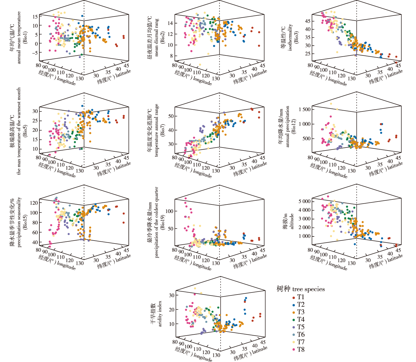
【Objective】The geographical distribution characteristics of tree species reflect climate trends, while climate change in turn influences their distribution. The interaction between these provides a theoretical basis for studying the geographical distribution and origin of tree species, as well as formulating conservation strategies.【Method】Taking eight naturally distributed species of the Juniperus across the three-level geographical terrains as the research subjects, this study employed analysis of variance (ANOVA), coefficient of variation, linear regression analysis, principal component analysis (PCA), and linear discriminant analysis (LDA) on climate and altitude data from 222 sampling sites. The aim was to compare and identify the dominant factors restricting the formation of the geographical distribution pattern of Juniperus species.【Result】Significant differences (P<0.001) were observed among the eight species in terms of annual mean temperature, mean diurnal range, isothermality, the max temperature of the warmest month, temperature annual range, annual precipitation, precipitation seasonality, precipitation of the coldest quarter, altitude, and aridity index. Among these factors, the variance in isothermality, temperature annual range, annual precipitation, altitude, and aridity index originated primarily from interspecific differences, while the variance in the remaining five factors originated mainly from intraspecific variations. The coefficients of variation for mean diurnal range, isothermality, the max temperature of the warmest month, temperature annual range, and precipitation seasonality were approximately 20%, indicating strong restrictive effects. Latitude and longitude were significantly correlated with isothermality, the max temperature of the warmest month, temperature annual range, precipitation seasonality and altitude, with negative correlations observed for isothermality and altitude.The temperature annual range, isothermality, precipitation seasonality, the max temperature of the warmest month, and altitude were the main drivers of geographical distribution differences among the eight Juniperus species, and the contribution of temperature-related factors exceeded that of precipitation-related ones. The eight species were roughly divided into two groups: the dry-cold zone group, including J. sabina var. davurica, J. rigida, J. sabina and J. pseudosabina; and the warm-humid zone group, including J. przewalskii, J. tibetica, J. saltuaria and J. indica.【Conclusion】Temperature (isothermality, the max temperature of the warmest month, temperature annual range), moisture (precipitation seasonality), and altitude collectively drive the geographical distribution of each Juniperus species, with temperature exerting a greater influence than moisture. Altitude readjusts the hydrothermal conditions in areas with the same latitude and longitude. This study presents the mean values and ranges of temperature, moisture, and altitude for the suitable distribution areas of the eight species, providing a theoretical reference for future ex-situ cultivation.The findings indicate that Juniperus species prefer cold and humid environments, reflecting their characteristics as part of the Holarctic flora.
Juniperus / geographical distribution pattern / dominant factor / climate / altitude
| [1] |
|
| [2] |
|
| [3] |
|
| [4] |
|
| [5] |
毛康珊. 广义柏科的生物地理学研究:从板块漂移理论到冰期避难所[D]. 兰州: 兰州大学, 2010.
|
| [6] |
|
| [7] |
|
| [8] |
. This study aimed to elucidate the relationship between climate and the phylogenetic and morphological divergence of spruces (Picea) worldwide. Climatic and georeferenced data were collected from a total of 3388 sites distributed within the global domain of spruce species. A phylogenetic tree and a morphological tree for the global spruces were reconstructed based on DNA sequences and morphological characteristics. Spatial evolutionary and ecological vicariance analysis (SEEVA) was used to detect the ecological divergence among spruces. A divergence index (D) with (0, 1) scaling was calculated for each climatic factor at each node for both trees. The annual mean values, extreme values and annual range of the climatic variables were among the major determinants for spruce divergence. The ecological divergence was significant (P < 0. 001) for 185 of the 279 comparisons at 31 nodes in the phylogenetic tree, as well as for 196 of the 288 comparisons at 32 nodes in the morphological tree. Temperature parameters and precipitation parameters tended to be the main driving factors for the primary divergences of spruce phylogeny and morphology, respectively. Generally, the maximum D of the climatic variables was smaller in the basal nodes than in the remaining nodes. Notably, the primary divergence of morphology and phylogeny among the investigated spruces tended to be driven by different selective pressures. Given the climate scenario of severe and widespread drought over land areas in the next 30–90 years, our findings shed light on the prediction of spruce distribution under future climate change.
|
| [9] |
中国植被编辑委员会. 中国植被[M]. 北京: 科学出版社,1980.
Chinese Vegetation Editorial Committee. Chinese vegetation[M]. Beijing: Science Press,1980.
|
| [10] |
李文华, 周沛村. 暗针叶林在欧亚大陆分布的基本规律及其数学模型的研究[J]. 资源科学, 1979, 1(1):21-34.
无
|
| [11] |
王思齐, 朱章明. 中国蔷薇属植物物种丰富度分布格局及其与环境因子的关系[J]. 生态学报, 2022, 42(1):209-219.
|
| [12] |
|
| [13] |
王静. 川渝地区马先蒿属物种多样性及其与环境因子的关系[D]. 成都: 四川大学, 2005.
|
| [14] |
孟和, 姜真杰, 张国盛. 内蒙古臭柏不同分布区生长与生态因子的关联分析[J]. 浙江农林大学学报, 2010, 27(1):51-56.
|
| [15] |
|
| [16] |
|
| [17] |
|
| [18] |
|
| [19] |
李贺, 张维康, 王国宏. 中国云杉林的地理分布与气候因子间的关系[J]. 植物生态学报, 2012, 36(5):372-381.
为了揭示中国云杉林的地理分布与气候因子间的关系, 在中国云杉林15个群系的地理分布范围内选取613个地理坐标点, 其中包括云杉各个种分布的海拔上限和下限坐标点各235和228个。通过数字地球系统确定每个点的海拔高程, 从中国气象插值数据库获取每个点的气候数据。数据分析分别采用线性回归、变异系数比较和主成分分析(PCA)法。结果显示, 中国云杉林分布范围内, 年平均气温、最冷月平均气温、最热月平均气温、≥5 ℃积温、≥0 ℃积温、年降水量、土壤水分含量和干燥指数α的平均值分别是3.38 ℃、–9.75 ℃、14.78 ℃、1 227.83 ℃·d、2 271.19 ℃·d、712.23 mm、80.02%和0.50; 各气候因子与中国云杉林垂直分布的上下限间均具有显著的回归关系; 除了年平均气温和最冷月平均气温变异系数较大外, 其他6个气候因子的变异系数均较小, 且彼此间无显著差异; 无论是云杉分布的上限还是下限, ≥5 ℃积温和≥0 ℃积温在PCA第一主分量具有较高的载荷, 而年降水量和土壤水分含量在第二、三主分量具有较高的载荷。影响中国云杉林分布的主要气候因子是生长季节积温, 其次是年降水量和土壤水分含量。
<p><em>Aims</em> Our objective was to examine the relationship between climatic factors and geographical distribution of spruce forests in China.</br><em>Methods</em> We sampled 613 points within the geographical range of Chinese spruce forests, of which 235 points were at the upper altitudinal limit and 228 at the lower altitudinal limit. The elevation for each point was determined using Google Earth while climatic data were from the Chinese meteorological interpolation database. Linear regression, comparison of coefficient of variation (<em>CV)</em> and principal component analysis (PCA) were conducted for data analysis.</br><em>Important findings</em> Within the distribution range of Chinese spruce forests, mean values of mean annual air temperature (<em>MAT</em>), mean air temperature of the coldest month (<em>MTCM</em>), mean air temperature of the warmest month (<em>MTWM</em>), growing degree days on a 5 ℃ basis (<em>GDD<sub>5</sub></em>) and on a 0 ℃ basis (<em>GDD<sub>0</sub></em>), mean annual precipitation (<em>MAP</em>), soil moisture (<em>SM</em>) and aridity index (<em>α</em>) are 3.38 ℃, –9.75 ℃, 14.78 ℃, 1 227.83 ℃·d, 2 271.19 ℃·d, 712.23 mm, 80.02% and 0.50, respectively. Both the upper and lower limits of altitude were significantly correlated with each of the climatic factors. In terms of <em>CV</em>, <em>MAT</em> and <em>MTCM</em> are significantly higher than the other six climatic factors; however, no significant differences were detected among those six. In addition, <em>GDD<sub>5</sub></em> and <em>GDD<sub>0</sub></em> have higher loading on the first principal component, yet <em>MAP</em> and <em>SM</em> have higher loading on the second and third principal component. Major conclusions are that <em>GDD<sub>0</sub></em> and <em>GDD<sub>5</sub></em> are likely the key factors that influence the distribution of Chinese spruce forest, followed by <em>MAP</em> and <em>SM</em>.</p>
|
| [20] |
邱明宇, 王飞, 南芳茹, 等. 中国串珠藻科植物地理分布及与环境因子的关系[J]. 水生生物学报, 2021, 45(2):455-463.
|
| [21] |
|
| [22] |
|
| [23] |
|
| [24] |
|
| [25] |
|
| [26] |
|
| [27] |
张晓玮, 王婧如, 王明浩, 等. 中国云杉属树种地理分布格局的主导气候因子[J]. 林业科学, 2020, 56(4):1-11.
|
| [28] |
|
| [29] |
李晓笑, 陶翠, 王清春, 等. 中国亚热带地区4种极危冷杉属植物的地理分布特征及其与气候的关系[J]. 植物生态学报, 2012, 36(11):1154-1164.
|
| [30] |
刘然, 王春晶, 何健, 等. 气候变化背景下中国冷杉属植物地理分布模拟分析[J]. 植物研究, 2018, 38(1):37-46.
中国是世界上冷杉属(Abies Mill.)植物种类最为丰富、分布地域最广的国家,也是研究冷杉属植物分布成因与规律的关键地区。本文通过中国数字植物标本馆、全球生物多样性信息数据库和相关文献三种途径收集我国冷杉属植物的地理分布数据,结合当前和未来气候情景,应用最大熵模型(MaxEnt)模拟冷杉属植物的潜在分布,并使用GIS的空间分析功能做生境适宜性分析,评估我国各地区对冷杉属植物的保护能力。结果显示:(1)四川西南部、云南北部、西藏自治区东南部是我国冷杉属植物分布的热点地区;(2)在未来气候变化情景下,我国冷杉属植物的适宜生境面积将明显减少;(3)适宜生境在未来有向北迁移的趋势;(4)就各地区保护能力而言,在当前气候情景下,云南省的保护能力最高,在未来,我国西部地区的保护能力呈上升趋势,中部和东部地区呈下降趋势。本研究可为冷杉属植物的保护工作提供一定的理论依据和参考价值。
China is the country which has the most abundant and the widest geographical distribution of <em>Abies</em> Mill. species in the world. It is also the key area for studying the causes and law of <em>Abies</em> distribution. We collected the data of geographical distribution of <em>Abies</em> in China in three ways: Chinese Virtual Herbarium, Global Biodiversity Information Facility and relevant literatures. Based on the current and future climate scenarios, the maximum entropy model(MaxEnt) was used to simulate the potential distribution of <em>Abies</em>. Also, we analysed of habitat suitability and evaluated the protective capability of various regions in China, using GIS spatial analysis functions. The results showed that: (1)Southwestern Sichuan, northern Yunnan, as well as southeastern Tibet are the hot spots for <em>Abies</em> in China; (2)The area of suitable habitat of <em>Abies</em> in China will significantly reduce under the future climate change scenario; (3)The suitable habitat has the tendency of moving northwards in the future; (4)Yunnan province has the highest protective capability under the current climate scenario. Under the future climate change scenario, the protective capability of the western regions in China will increase, while that of the central and eastern regions will decline. This study can provide a theoretical basis and reference value for the protection of <em>Abies</em>.
|
| [31] |
徐振朋, 张佳琦, 宛涛, 等. 孑遗植物裸果木历史分布格局模拟及避难区研究[J]. 西北植物学报, 2017, 37(10):2074-2081.
|
| [32] |
|
| [33] |
|
/
| 〈 |
|
〉 |