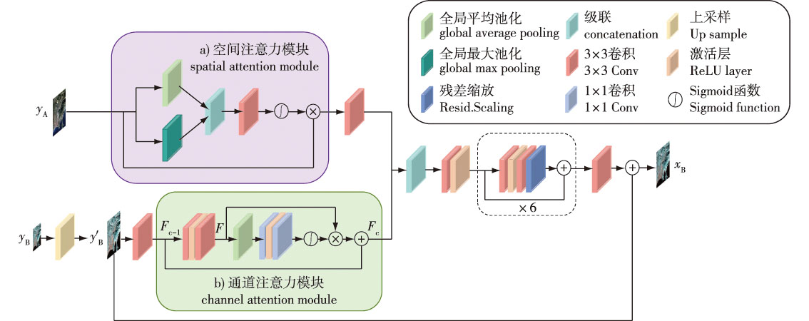
【Objective】This study aims to enhance the spatial resolution of Sentinel-2 satellite remote sensing imagery by applying deep learning and image fusion techniques, thereby improving the accuracy and reliability of surface information extraction, so as to provide robust data support for subsequent precise investigation and monitoring of forest resources, agricultural yield prediction, and related applications.【Method】A super-resolution reconstruction method for Sentinel-2 imagery, based on a spatial-channel dual-stream attention mechanism, was proposed. Considering the inherent multi-spectral and multi-resolution characteristics of remote sensing images, a dual-branch model was designed to differentially process high-resolution (HR) and low-resolution (LR) spectral bands. The spatial attention mechanism was introduced into the HR branch to precisely capture intricate spatial details. Conversely, the channel attention mechanism was applied to the LR branch to dynamically adjust the weight distribution of spectral features, enhancing spectral feature representation. During the feature fusion stage, a deep feature extraction strategy was employed to effectively integrate spatial and spectral features, generating composite multidimensional feature representations. Additionally, a combined loss function incorporating both L1 loss and edge loss was utilized to facilitate effective feedback learning, ultimately achieving high-quality super-resolution reconstruction.【Result】Experiments were conducted on two data scales: downsampled images from three distinct regions and real Sentinel-2 images. The results demonstrated that the proposed method outperformed comparative algorithms in both objective evaluation metrics and subjective visual quality. Specifically, for the downsampled image data, the proposed method achieved a reduction in Root Mean Square Error (RMSE) of at least 50.33 compared with the bicubic interpolation method, and at least 1.64 compared to the DSen2 method. For the real image data, the proposed method yielded significantly clearer and more natural visual results.【Conclusion】The dual-stream attention model proposed in this study effectively improved the spatial resolution of Sentinel-2 satellite imagery. This enhancement can facilitate the generation of high-quality data for applications such as crop health detection and land use analysis, thereby expanding the potential utility of Sentinel-2 data across multiple domains.
 PDF(5872 KB)