Evaluation and zoning of rural greenway landscape features based on landscape resources

Zheng Jie, He Junjun, Bai Xuefeng, Xu Hao, Hu Zhijie

Journal of Nanjing Forestry University (Natural Sciences Edition) ›› 2026, Vol. 50 ›› Issue (4) : 278-285.

PDF(5073 KB)
PDF(5073 KB)
Journal of Nanjing Forestry University (Natural Sciences Edition) ›› 2026, Vol. 50 ›› Issue (4) : 278-285. DOI: 10.12302/j.issn.1000-2006.202501037

Evaluation and zoning of rural greenway landscape features based on landscape resources

Author information +
History +

Abstract

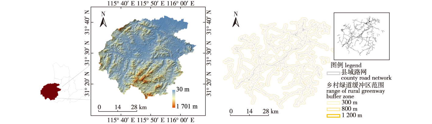
【Objective】To address the insufficient resource integration and imprecise spatial characterization in rural greenway planning, this study establishes a multidimensional landscape resource identification system integrating ecology, culture, and production, and proposes a scientific zoning method for optimizing greenway design.【Method】Using the countywide road network of Jinzhai County, Anhui Province as the primary study object, three buffer distances (300 m, 800 m, and 1 200 m) were established along roads to analyze the gradient effects of roads on adjacent landscape resources. A spatially constrained multivariate clustering model (SCMC) was introduced and integrated with multi-source data and GIS to identify landscape-resource characteristics across three dimensions—natural ecology, cultural activities, and agricultural production—and dominant landscape-character zones were delineated based on the clustering results.【Result】(1) Ecological resources clustered in the southern region, showing a “high-south, low-north” pattern, while cultural resources concentrated in the north with the lowest proportion of transportation facilities, and agricultural resources exhibited significant spatial heterogeneity. (2) Five dominant greenway zones were identified with strong regional independence, particularly in the distribution of cultural resources, and the greenways can be functionally classified into four types—ecological, cultural, production-oriented, and composite—prioritizing, respectively, ecological conservation and tourism/recreation; cultural-heritage transmission; agricultural economic value; and an organic integration of cultural and productive functions. (3) Four functional zones (ecological, cultural, agricultural, and composite) were delineated in Jinzhai County.【Conclusion】In view of the complex nature of rural environments, the identification of rural greenway landscape features should transcend the traditional single-dimensional evaluation paradigm and establish a multidimensional identification framework; through differentiated strategies—such as ecological-corridor construction, culture-industry linkages, and the integration of agricultural production—multifunctional synergy and spatial optimization of rural greenways can be achieved, thereby providing scientific support for rural revitalization.
Key words

rural greenway / landscape resources / landform characteristics / spatial multivariate constrained clustering / Jinzhai County, Anhui Province

Cite this article

Download Citations
Zheng Jie , He Junjun , Bai Xuefeng , et al . Evaluation and zoning of rural greenway landscape features based on landscape resources[J]. Journal of Nanjing Forestry University (Natural Sciences Edition). 2026, 50(4): 278-285 https://doi.org/10.12302/j.issn.1000-2006.202501037

References

[1]
徐文辉. 浙江省乡村绿道发展模式创建[J]. 城市规划, 2010, 34(6):60-63.
Xu W H. Establishment of development model of rural greenway in Zhejiang[J]. City Planning Review, 2010, 34(6):60-63.
[2]
Liu C Y, Dou X T, Li J F, et al. Analyzing government role in rural tourism development:an empirical investigation from China[J]. Journal of Rural Studies, 2020, 79:177-188. DOI:10.1016/j.jrurstud.2020.08.046.
[3]
王琴, 郝琳哲. 基于低碳生态理念的绿道慢行系统设计研究[J]. 公路, 2024, 69(1):212-218.
Wang Q, Hao L Z. Design of greenway slow-moving system based on low-carbon ecological concept[J]. Highway, 2024, 69(1):212-218.
[4]
顾浩, 王兰, 张钰彤, 等. 基于健康理念的绿道规划设计导则优化[J]. 规划师, 2024, 40(2):74-81.
Gu H, Wang L, Zhang Y T, et al. Optimizing greenway planning and design guidelines based on health concepts[J]. Planners, 2024, 40(2):74-81. DOI:10.3969/j.issn.1006-0022.2024.02.010.
[5]
郑段雅, 周星宇, 何迎佳, 等. 基于多源大数据和网络模型的城市绿道精细化选线研究:以武汉市城市绿道为例[J]. 现代城市研究, 2023(8):113-118.
Zheng D Y, Zhou X Y, He Y J, et al. The research on urban greenway fineness route selection technology based on multivariate big data and network model:a cace study of Wuhan greenways[J]. Modern Urban Research, 2023(8):113-118. DOI:10.3969/j.issn.1009-6000.2023.08.016.
[6]
郭屹岩, 姚有庆, 李钢, 等. 绿道网络重塑乡村舒适性空间策略:以振江镇为例[J]. 西安建筑科技大学学报(自然科学版), 2022, 54(1):76-84.
Guo Y Y, Yao Y Q, Li G, et al. Strategy of reconstructing rural amenity space by greenway network:a case study of Zhenjiang Town[J]. Journal of Xi’an University of Architecture & Technology, 2022, 54(1):76-84. DOI:10.15986/j.1006-7930.2022.01.010.
[7]
谢波, 肖扬谋, 王潇. 城市绿道使用对居民健康的影响研究:以武汉东湖绿道为例[J]. 中国园林, 2022, 38(11):40-45.
Xie B, Xiao Y M, Wang X. Exploring the effect of urban greenway use on residents’ health:evidence from the east lake greenway in Wuhan,China[J]. Chinese Landscape Architecture, 2022, 38(11):40-45. DOI:10.19775/j.cla.2022.11.0040.
[8]
胡玲, 陈挺帅, 顾力天, 等. 风景型绿道的设计研究:以青山湖绿道二期设计为例[J]. 中国园林, 2022, 38(S1):59-64.
Hu L, Chen T S, Gu L T, et al. Study on the design of scenic greenway:a case study of the design of the second phase of Qingshan Lake greenway[J]. Chinese Landscape Architecture, 2022, 38(S1):59-64. DOI:10.19775/j.cla.2022.S1.0059.
[9]
周琪超, 徐文辉. 乡村产业绿道选线适宜性评价研究[J]. 中国园林, 2021, 37(1):89-94.
Zhou Q C, Xu W H. Study on suitability evaluation of route selection in rural industry greenway[J]. Chinese Landscape Architecture, 2021, 37(1):89-94. DOI:10.19775/j.cla.2021.01.0089.
[10]
吴雪, 张云路, 李雄. 基于“三生空间” 协同的乡村绿道选线研究:以怀柔科学城为例[J]. 城市发展研究, 2021, 28(1):27-32.
Wu X, Zhang Y L, Li X. Research on rural greenway route selection based on the coordination of “production-living-ecological space”:a case of Huairou science city[J]. Urban Development Studies, 2021, 28(1):27-32. DOI:10.3969/j.issn.1006-3862.2021.01.016.
[11]
卜昌荣, 陈漫华, 陈佩青. 基于乡土资源价值最大化利用的乡村绿道规划设计:以姜家镇十里水果长廊绿道为例[J]. 中国园林, 2020, 36(S2):59-62.
Bu C R, Chen M H, Chen P Q. Planning and design of rural greenway based on maximizing the value of local resources:taking the Jiangjia Town ten-mile fruit corridor greenway as an example[J]. Chinese Landscape Architecture, 2020, 36(S2):59-62. DOI:10.19775/j.cla.2020.S2.0059.
[12]
丁金华, 汪大庆. “三生”空间视角下苏南水网乡村景观生态风险评价:以石头潭片区为例[J]. 西北林学院学报, 2024, 39(2):265-273.
Ding J H, Wang D Q. Ecological risk assessment of rural landscape of southern Jiangsu water net from the perspective of “ecology-production-living” space:a case study of stone pool area[J]. Journal of Northwest Forestry University, 2024, 39(2):265-273.
[13]
肖时珍, 肖华, 吴宇辉. 基于GIS视域分析的项目建设对世界遗产景观美学价值的影响评价:以武陵源世界自然遗产地为例[J]. 桂林理工大学学报, 2020, 40(3):516-522.
Xiao S Z, Xiao H, Wu Y H. Assessment of construction project on the aesthetic values of world heritage landscape based on GIS viewshed analysis:a case study of Wulingyuan World Natural Heritage Site[J]. Journal of Guilin University of Technology, 2020, 40(3):516-522.
[14]
黄莹莹, 谈石柱, 陈倩婷, 等. 基于景观特征识别和评价的乡村景观营造模式[J]. 浙江农林大学学报, 2022, 39(4):894-901.
Huang Y Y, Tan S Z, Chen Q T, et al. Rural landscape construction model based on the recognition and evaluation of landscape features[J]. Journal of Zhejiang A&F University, 2022, 39(4):894-901. DOI:10.11833/j.issn.2095-0756.20210644.
[15]
张旻桓, 沈守云, 刘二冬. 南宁青秀山风景资源评价[J]. 中南林业科技大学学报, 2011, 31(8):130-135.
Zhang M H, Shen S Y, Liu E D. Evaluation of scenic resources of Qingxiushan in Nanning City[J]. Journal of Central South University of Forestry & Technology, 2011, 31(8):130-135. DOI:10.14067/j.cnki.1673-923x.2011.08.005.
[16]
胡佳媛, 刘灵豫, 代勤龙, 等. 基于AHP-GIS的生态旅游适宜性评价:以大熊猫国家公园小相岭片区及周边社区为例[J]. 应用生态学报, 2024, 35(3):780-788.
Hu J Y, Liu L Y, Dai Q L, et al. Evaluation of ecotourism suitability based on AHP-GIS:taking Xiaoxiangling area of the Giant Panda National Park and the surrounding communities as an example[J]. Chinese Journal of Applied Ecology, 2024, 35(3):780-788. DOI:10.13287/j.1001-9332.202403.020.
[17]
Nie Z Y, Dong T, Pan W. Spatial differentiation and geographical similarity of traditional villages:take the Yellow River basin and the Yangtze River basin as examples[J]. PLoS One, 2024, 19(2):e0295854. DOI:10.1371/journal.pone.0295854.
[18]
Sisman S, Aydinoglu A C. Improving performance of mass real estate valuation through application of the dataset optimization and Spatially Constrained Multivariate Clustering Analysis[J]. Land Use Policy, 2022, 119:106167. DOI:10.1016/j.landusepol.2022.106167.
[19]
Assuncão R M, Neves M C, Câmara G, et al. Efficient regionalization techniques for socio-economic geographical units using minimum spanning trees[J]. International Journal of Geographical Information Science, 2006, 20(7):797-811. DOI:10.1080/13658810600665111.
[20]
胡长涓, 傅静雯, 宫聪. 基于 “综合生态观” 的历史街区复兴研究框架[J]. 室内设计与装修, 2025(6):120-122.
Hu C J, Fu J W, Gong C. Research framework for the revival of historic districts based on ‘Comprehensive Ecological View’[J]. Interior Design Construction, 2025(6):120-122. DOI:10.3969/j.issn.1005-7374.2025.06.026.
[21]
田乐. 安徽省金寨县红色文化资源保护与利用研究[D]. 合肥: 安徽农业大学, 2022.
Tian L. Study on protection and utilization of red cultural resources in Jinzhai County,Anhui Province[D]. Hefei: Anhui Agricultural University, 2022.
[22]
黄卫, 尹雯, 宋健. 农村居民点空间分布特征及影响因素研究:以湖北省恩施市为例[J]. 国土与自然资源研究, 2024(6):84-88.
Huang W, Yin W, Song J. Spatial distribution characteristics and influencing factors of rural settlements:a case of Enshi City,Hubei Province[J].Territory & Natural Resources Study,2024(6):84-88. DOI:10.16202/j.cnki.tnrs.2024.06.017.
[23]
国安东, 李永化, 杨俊. 基于多距离空间聚类的城市建筑景观时空分异研究[J]. 测绘通报, 2017(2):102-105.
Guo A D, Li Y H, Yang J. Research on spatial and temporal differences of urban architectural landscape based on multi-distance spatial cluster[J]. Bulletin of Surveying and Mapping, 2017(2):102-105. DOI:10.13474/j.cnki.11-2246.2017.0059.
[24]
刘岳, 李忠武, 唐政洪, 等. 基于适宜性分析与GIS的长沙市大河西先导区城市绿道网络设计[J]. 生态学杂志, 2012, 31(2):426-432.
Liu Y, Li Z W, Tang Z H, et al. Greenway network design of Great West River Pilot Area in Changsha City,Hunan Province of south-central China based on suitability analysis and GIS[J]. Journal of Ecology, 2012, 31(2):426-432. DOI:10.13292/j.1000-4890.2012.0048.
[25]
郭屹岩, 刘利, 张春鹏. 基于绿道网络构建乡村生态体验旅游空间:以宽甸满族自治县为例[J]. 农业现代化研究, 2018, 39(3):486-493.
Guo Y Y, Liu L, Zhang C P. Greenway network based ecological experience tourism space construction in rural areas:a case study of Kuandian Manchu Autonomous County[J]. Research of Agricultural Modernization, 2018, 39(3):486-493. DOI:10.13872/j.1000-0275.2018.0033.
[26]
高子轶, 卓玛措, 张俊英, 等. 青藏高原生态旅游资源与基础设施空间协同的区划研究[J]. 干旱区资源与环境, 2024, 38(3):172-181.
Gao Z Y, Zhuo M C, Zhang J Y, et al. Regional division of spatial synergy between ecological tourism resources and infrastructures on the Qinghai-Tibet Plateau[J]. Journal of Arid Land Resources and Environment, 2024, 38(3):172-181. DOI:10.13448/j.cnki.jalre.2024.065.
[27]
蔡文婷, 姜娜, 佃袁勇, 等. 乡村景观资源特征指标体系构建[J]. 风景园林, 2022, 29(3):25-30.
Cai W T, Jiang N, Dian Y Y, et al. The construction of rural landscape resource characteristics index system[J]. Landscape Architecture, 2022, 29(3):25-30. DOI:10.14085/j.fjyl.2022.03.0025.06.
[28]
张耀元, 林墨飞. 边疆乡村生态旅游绿道选线研究:以黑河市坤河达斡尔族满族乡为例[J]. 中国园林, 2024, 40(3):101-107.
Zhang Y Y, Lin M F. Research on the selection of green lanes for ecotourism in frontier rural areas:taking daur Manchu township of Kunhe in Heihe City as an example[J]. Chinese Landscape Architecture, 2024, 40(3):101-107. DOI:10.19775/j.cla.2024.03.0101.
[29]
方轶轶, 闻鸿, 曾慕琳. 基于POI的公共服务设施核密度分析:以眉山市北部新城区为例[J]. 中国水运, 2022, 22(6):150-152,155.
Fang Y Y, Wen H, Zeng M L. Analysis on the nuclear density of public service facilities based on POI:a case study of the northern new town of Meishan City[J]. China Water Transport, 2022, 22(6):150-152,155.
[30]
夏梦婷, 徐文辉. 基于多功能协同评价模型的乡村绿道规划研究[J]. 中国园林, 2021, 37(11):86-91.
Xia M T, Xu W H. Research on rural greenway planning based on the multifunctional collaborative evaluation model[J]. Chinese Landscape Architecture, 2021, 37(11):86-91. DOI:10.19775/j.cla.2021.11.0086.
[31]
牛小溪, 谭立峰, 刘芳, 等. 基于空间统计分析和地理探测器的中国海洋文化遗产空间区划[J]. 热带地理, 2024, 44(3):532-546.
Niu X X, Tan L F, Liu F, et al. Spatial zoning of China’s marine cultural heritage based on spatial statistical analysis and GeoDetector[J]. Tropical Geography, 2024, 44(3):532-546. DOI:10.13284/j.cnki.rddl.003842.
PDF(5073 KB)

Accesses

Citation

Detail

Sections
Recommended
The full text is translated into English by AI, aiming to facilitate reading and comprehension. The core content is subject to the explanation in Chinese.

/