Research on forest change detection based on fully convolutional network and low resolution label

XIANG Jun, YAN Enping, JIANG Jiawei, SONG Yabin, WEI Wei, MO Dengkui

JOURNAL OF NANJING FORESTRY UNIVERSITY ›› 2024, Vol. 48 ›› Issue (1) : 187-195.

PDF(4436 KB)
PDF(4436 KB)
JOURNAL OF NANJING FORESTRY UNIVERSITY ›› 2024, Vol. 48 ›› Issue (1) : 187-195. DOI: 10.12302/j.issn.1000-2006.202204069

Research on forest change detection based on fully convolutional network and low resolution label

Author information +
History +

Abstract

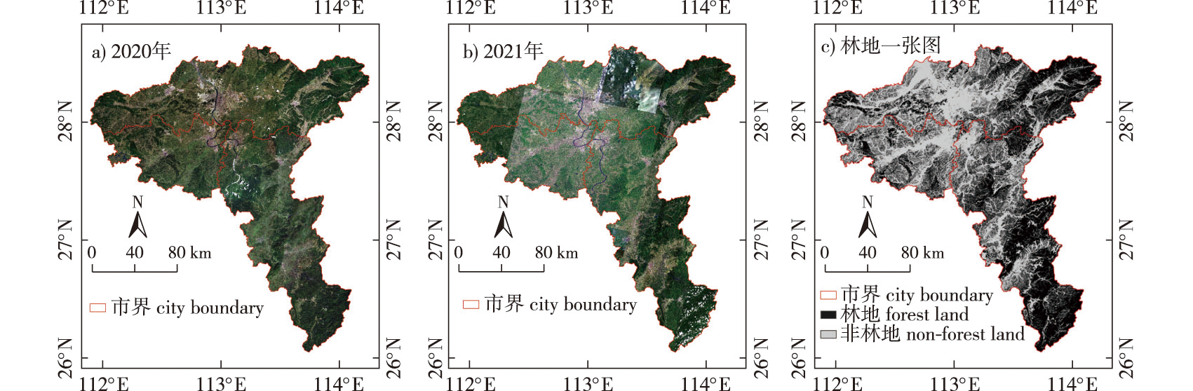
【Objective】A forest change detection method based on fully convolutional networks and low resolution labels is proposed to address the problem of missing or insufficient high-precision label samples in current forest change detection, with the goal of achieving simple and rapid extraction of forest changes in forest areas. 【Method】First, the gathered data was de-clouded, screened and labeled, and then the fully convolutional network model was used to extract the forests in high-scoring remote sensing photos in the study area in 2020 and 2021, respectively, and the model accuracy was evaluated. The forest change area was calculated using the post-classification comparison method, and the findings were compared with visual interpretation results. The pixel area was used to calculate evaluation indicators, such as forest change detection accuracy. 【Result】Experiments reveal that the F1 score of the model employed in this research is 97.09% in 2020 forest extraction results and 95.96% in 2021 forest extraction results, which was the best among segmentation network models (U-Net, FPN, LinkNet). The total change precision rate of forest increase and forest decline was 73.30%, the recall rate was 77.37%, and the F1 score was 75.28% when comparing the forest extraction data from the two periods to obtain the changed area. 【Conclusion】Based on low resolution labeling, this method allows for the speedy and precise capture of forest change regions from high-resolution remote sensing pictures. To accomplish forest change detection, a small number of low-resolution labels are used, which can also serve as a reference for large-scale forestland change inquiries.

Key words

low resolution label / fully convolutional network / deep learning / forest changes detection

Cite this article

Download Citations
XIANG Jun , YAN Enping , JIANG Jiawei , et al . Research on forest change detection based on fully convolutional network and low resolution label[J]. JOURNAL OF NANJING FORESTRY UNIVERSITY. 2024, 48(1): 187-195 https://doi.org/10.12302/j.issn.1000-2006.202204069

References

[1]
魏安世, 杨志刚. 森林资源年度监测小班数据自动更新技术[J]. 南京林业大学学报(自然科学版), 2010, 34(4):123-128.
WEI A S, YANG Z G. Automatic updating technique of subcompartment data for annual monitoring of forest resource[J]. J Nanjing For Univ (Nat Sci Ed), 2010, 34(4):123-128.DOI: 10.3969/j.issn.1000-2006.2010.04.027.
[2]
刘羿, 佘光辉, 刘安兴, 等. 森林资源系统自组织特征研究[J]. 南京林业大学学报(自然科学版), 2008, 32(5):51-55.
LIU Y, SHE G H, LIU A X, et al. Research on self-organization characters in forest resource system[J]. J Nanjing For Univ (Nat Sci Ed), 2008, 32(5):51-55.DOI: 10.3969/j.issn.1000-2006.2008.05.012.
[3]
李春干, 梁文海. 基于面向对象变化向量分析法的遥感影像森林变化检测[J]. 国土资源遥感, 2017, 29(3):77-84.
LI C G, LIANG W H. Forest change detection using remote sensing image based on object-oriented change vector analysis[J]. Remote Sens Land Resour, 2017, 29(3):77-84.DOI: 10.6046/gtzyyg.2017.03.11.
[4]
张丽云, 赵天忠, 夏朝宗, 等. 遥感变化检测技术在林业中的应用[J]. 世界林业研究, 2016, 29(2):44-48.
ZHANG L Y, ZHAO T Z, XIA C Z, et al. Application of change detection technologies of remote sensing to forestry[J]. World For Res, 2016, 29(2):44-48.DOI: 10.13348/j.cnki.sjlyyj.2016.02.005.
[5]
张祖宇, 滕永核, 秦元丽, 等. 基于U-Net模型的无人机影像数据地表覆被信息自动提取研究[J]. 广西林业科学, 2022, 51(4):516-519.
ZHANG Z Y, TENG Y H, QIN Y L, et al. Automatic extraction of land cover information from UAV image data based on U-Net model[J]. Guangxi Forest Sci, 2022, 51(4):516-519.DOI: 10.19692/j.issn.1006-1126.20220411.
[6]
王利民, 刘佳, 杨玲波, 等. 基于无人机影像的农情遥感监测应用[J]. 农业工程学报, 2013, 29(18):136-145.
WANG L M, LIU J, YANG L B, et al. Applications of unmanned aerial vehicle images on agricultural remote sensing monitoring[J]. Trans Chin Soc Agric Eng, 2013, 29(18):136-145.DOI: 10.3969/j.issn.1002-6819.2013.18.017.
[7]
ZHAO S H, WANG Q, LI Y, et al. An overview of satellite remote sensing technology used in China’s environmental protection[J]. Earth Sci Inform, 2017, 10(2):137-148.DOI: 10.1007/s12145-017-0286-6.
[8]
ROGAN J, CHEN D M. Remote sensing technology for mapping and monitoring land-cover and land-use change[J]. Prog Plan, 2004, 61(4):301-325.DOI: 10.1016/S0305-9006(03)00066-7.
[9]
郭颖, 李增元, 陈尔学, 等. 一种改进的高空间分辨率遥感影像森林类型深度学习精细分类方法:双支FCN-8s[J]. 林业科学, 2020, 56(3):48-60.
GUO Y, LI Z Y, CHEN E X, et al. A deep learning method for forest fine classification based on high resolution remote sensing images:two-branch FCN-8s[J]. Sci Silvae Sin, 2020, 56(3):48-60.DOI: 10.11707/j.1001-7488.20200306.
[10]
覃先林, 李晓彤, 刘树超, 等. 中国林火卫星遥感预警监测技术研究进展[J]. 遥感学报, 2020, 24(5):511-520.
QIN X L, LI X T, LIU S C, et al. Forest fire early warning and monitoring techniques using satellite remote sensing in China[J]. J Remote Sens, 2020, 24(5):511-520.
[11]
杨雷, 禹定峰, 高皜, 等. Sentinel-2的胶州湾水体透明度遥感反演[J]. 红外与激光工程, 2021, 50(12):515-521.
YANG L, YU D F, GAO H, et al. Remote sensing retrieval of secchi disk depth in Jiaozhou Bay using Sentinel-2 MSI image[J]. Infrared Laser Eng, 2021, 50(12):515-521.
[12]
陈锐志, 王磊, 李德仁, 等. 导航与遥感技术融合综述[J]. 测绘学报, 2019, 48(12):1507-1522.
CHEN R Z, WANG L, LI D R, et al. A survey on the fusion of the navigation and the remote sensing techniques[J]. Acta Geod Cartogr Sin, 2019, 48(12):1507-1522.DOI: 10.11947/j.AGCS.2019.20190446.
[13]
GU J X, WANG Z H, KUEN J, et al. Recent advances in convolutional neural networks[J]. Pattern Recognit, 2018, 77:354-377.DOI: 10.1016/j.patcog.2017.10.013.
[14]
SHELHAMER E, LONG J, DARRELL T. Fully convolutional networks for semantic segmentation[C]// IEEE Transactions on Pattern Analysis and Machine Intelligence.May 24,2016,IEEE, 2016:640-651.DOI: 10.1109/TPAMI.2016.2572683.
[15]
业巧林, 许平, 张冬. 基于深度学习特征和支持向量机的遥感图像分类[J]. 林业工程学报, 2019, 4(2):119-125.
YE Q L, XU D P, ZHANG D. Remote sensing image classification based on deep learning features and support vector machine[J]. J Fore Eng, 2019, 4(2):119-125.DOI:10.13360/j.issn.2096-1359.2019.02.019.
[16]
FU G, LIU C J, ZHOU R, et al. Classification for high resolution remote sensing imagery using a fully convolutional network[J]. Remote Sens, 2017, 9(5):498.DOI: 10.3390/rs9050498.
[17]
LIU R C, JIANG D W, ZHANG L L, et al. Deep depthwise separable convolutional network for change detection in optical aerial images[J]. IEEE J Sel Top Appl Earth Obs Remote Sens, 2020, 13:1109-1118.DOI: 10.1109/JSTARS.2020.2974276.
[18]
LEI T, ZHANG Q, XUE D H, et al. End-to-end change detection using a symmetric fully convolutional network for landslide mapping[C]// ICASSP 2019—2019 IEEE International Conference on Acoustics,Speech and Signal Processing (ICASSP). May 12-17,2019,Brighton,UK.IEEE, 2019:3027-3031.DOI: 10.1109/ICASSP.2019.8682802.
[19]
MILLETARI F, NAVAB N, AHMADI S A. V-net:fully convolutional neural networks for volumetric medical image segmentation[C]// 2016 Fourth International Conference on 3D Vision (3DV). October 25-28,2016,Stanford,CA,USA.IEEE, 2016:565-571.DOI: 10.1109/3DV.2016.79.
[20]
RONNEBERGER O, FISCHER P, BROX T. U-net:convolutional networks for biomedical image segmentation[C]//International Conference on Medical Image Computing and Computer-Assisted Intervention. Cham:Springer, 2015:234-241.DOI:10.1007/978-3-319-24574-4_28.
[21]
CHEN H, SHI Z W. A spatial-temporal attention-based method and a new dataset for remote sensing image change detection[J]. Remote Sens, 2020, 12(10):1662.DOI: 10.3390/rs12101662.
[22]
王昶, 张永生, 王旭, 等. 基于深度学习的遥感影像变化检测方法[J]. 浙江大学学报(工学版), 2020, 54(11):2138-2148.
WANG C, ZHANG Y S, WANG X, et al. Remote sensing image change detection method based on deep neural networks[J]. J Zhejiang Univ (Eng Sci), 2020, 54(11):2138-2148.DOI: 10.3785/j.issn.1008-973X.2020.11.009.
[23]
WANG Z Y, LIU M L, LIU X N, et al. Spatio-temporal evolution of surface urban heat islands in the Chang-Zhu-Tan urban agglomeration[J]. Phys Chem Earth Parts A/B/C, 2020, 117:102865.DOI: 10.1016/j.pce.2020.102865.
[24]
JIANG W G, DENG Y, TANG Z H, et al. Modelling the potential impacts of urban ecosystem changes on carbon storage under different scenarios by linking the CLUE-S and the InVEST models[J]. Ecol Model, 2017, 345:30-40.DOI: 10.1016/j.ecolmodel.2016.12.002.
[25]
马润, 胡斯勒图, 尚华哲, 等. 基于葵花-8卫星大气产品的地表下行短波辐射计算[J]. 遥感学报, 2019, 23(5):924-934.
MA R, HUSI L, SHANG H Z, et al. Estimation of downward surface shortwave radiation from Himawari-8 atmospheric products[J]. J Remote Sens, 2019, 23(5):924-934.
[26]
伟乐斯, 尚华哲, 胡斯勒图, 等. GF-5 DPC数据的云检测方法研究[J]. 遥感学报, 2021, 25(10):2053-2066.
WEI L S, SHANG H Z, HUSI L, et al. Cloud detection algorithm based on GF-5 DPC data[J]. J Remote Sens, 2021, 25(10):2053-2066.
[27]
PONTIUS R G, SHUSAS E, MCEACHERN M. Detecting important categorical land changes while accounting for persistence[J]. Agric Ecosyst Environ, 2004, 101(2/3):251-268.DOI: 10.1016/j.agee.2003.09.008.
[28]
KINGMA D P, BA J. Adam:a method for stochastic optimization[EB/OL]. arXiv:Learning, 2014.[2022-03-20]. https://arxiv.org/abs/1412.6980.
[29]
HAND D, CHRISTEN P. A note on using the F-measure for evaluating record linkage algorithms[J]. Stat Comput, 2018, 28(3):539-547.DOI: 10.1007/s11222-017-9746-6.
[30]
YIN H, PFLUGMACHER D, LI A, et al. Land use and land cover change in Inner Mongolia-understanding the effects of China’s re-vegetation programs[J]. Remote Sens Environ, 2018, 204:918-930.DOI: 10.1016/j.rse.2017.08.030.
[31]
JIN S M, YANG L M, ZHU Z, et al. A land cover change detection and classification protocol for updating Alaska NLCD 2001 to 2011[J]. Remote Sens Environ, 2017, 195:44-55.DOI: 10.1016/j.rse.2017.04.021.
[32]
LI J Y, HUANG X, CHANG X Y. A label-noise robust active learning sample collection method for multi-temporal urban land-cover classification and change analysis[J]. ISPRS J Photogramm Remote Sens, 2020, 163:1-17.DOI: 10.1016/j.isprsjprs.2020.02.022.
[33]
HARALICK R M, STERNBERG S R, ZHUANG X H. Image analysis using mathematical morphology[J]. IEEE Trans Pattern Anal Mach Intell, 1987, PAMI-9(4):532-550.DOI: 10.1109/TPAMI.1987.4767941.
[34]
吴胜义, 张方圆, 王飞. 林地变更调查技术方法分析与研究[J]. 林业科技, 2021, 46(2):38-41,45.
WU S Y, ZHANG F Y, WANG F. Analysis and research on technology and method of forest land change survey[J]. For Sci Technol, 2021, 46(2):38-41,45.DOI: 10.19750/j.cnki.1001-9499.2021.02.011.
[35]
徐新良, 刘纪远, 庄大方, 等. 中国林地资源时空动态特征及驱动力分析[J]. 北京林业大学学报, 2004, 26(1):41-46.
XU X L, LIU J Y, ZHUANG D F, et al. Spatial-temporal characteristics and driving forces of woodland resource changes in China[J]. J Beijing For Univ, 2004, 26(1):41-46.DOI: 10.3321/j.issn:1000-1522.2004.01.008.
[36]
夏传福, 李静, 柳钦火. 植被物候遥感监测研究进展[J]. 遥感学报, 2013, 17(1):1-16.
XIA C F, LI J, LIU Q H. Review of advances in vegetation phenology monitoring by remote sensing[J]. J Remote Sens, 2013, 17(1):1-16.
[37]
范德芹, 赵学胜, 朱文泉, 等. 植物物候遥感监测精度影响因素研究综述[J]. 地理科学进展, 2016, 35(3):304-319.
FAN D Q, ZHAO X S, ZHU W Q, et al. Review of influencing factors of accuracy of plant phenology monitoring based on remote sensing data[J]. Prog Geogr, 2016, 35(3):304-319.
PDF(4436 KB)

Accesses

Citation

Detail

Sections
Recommended
The full text is translated into English by AI, aiming to facilitate reading and comprehension. The core content is subject to the explanation in Chinese.

/