
JOURNAL OF NANJING FORESTRY UNIVERSITY ›› 2023, Vol. 47 ›› Issue (5): 9-18.doi: 10.12302/j.issn.1000-2006.202209011
Special Issue: 林草计算机应用研究专题
Previous Articles Next Articles
ZHANG Huacong1,2,3( ), TAN Xinjian3(), YU Longhua3, LI Yueqiao3, CHEN Yongfu1,2, LIU Ren3, ZHANG Huaiqing1,2,*()
Received:2022-09-05
Revised:2022-10-25
Online:2023-09-30
Published:2023-10-10
CLC Number:
ZHANG Huacong, TAN Xinjian, YU Longhua, LI Yueqiao, CHEN Yongfu, LIU Ren, ZHANG Huaiqing. Crown segmentation of CHM based on the enhanced frost local filtering and distance map reconstruction[J]. JOURNAL OF NANJING FORESTRY UNIVERSITY, 2023, 47(5): 9-18.
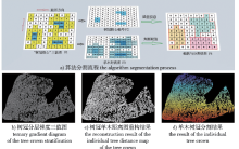
Fig. 1
Process of coniferous mixed forest division"
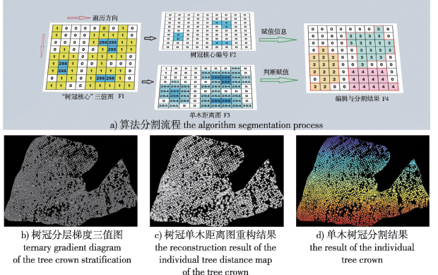
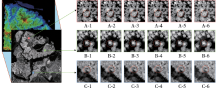
Fig. 2
Comparison of results of different filtering methods A, B and C respectively represent the canopy layer of mixed broad-leave forest, mixed coniferous forest, and coniferous broad-leaved forest. The same below. In the figure,1, 2, 3, 4, 5 and 6 respectively represent the original image, the result of the enhanced Frost filtering, the result of the enhanced Lee filtering, the result of the local Sigma filtering, the result of median filtering, and the result of the filtering method used in this study."

Table 1
Comparison of results of different filtering methods"
| 指标 index | 冠层类型 canopy layer type | 原始图像 original image | 增强Frost enhanced frost | 增强Lee enhanced Lee | 局部Sigma local sigma | 中值滤波 median filtering | 本研究 this research |
|---|---|---|---|---|---|---|---|
| 平滑指数(SI) smoothness index | A阔叶混交林 | 2.38 | 2.56 | 2.83 | 2.36 | 2.53 | 2.63 |
| B针叶混交林 | 3.06 | 3.39 | 3.39 | 3.13 | 3.34 | 3.31 | |
| C针阔混交 | 2.48 | 2.66 | 2.65 | 2.52 | 2.58 | 2.60 | |
| 均值 | 2.64 | 2.87 | 2.96 | 2.67 | 2.82 | 2.85 | |
| 信噪比(SNR) signal to noise ratio | A阔叶混交林 | 14.33 | 14.83 | 14.71 | 14.33 | 14.61 | 14.53 |
| B针叶混交林 | 13.25 | 14.05 | 14.05 | 13.35 | 13.79 | 13.61 | |
| C针阔混交 | 13.66 | 14.11 | 14.08 | 13.73 | 14.17 | 13.91 | |
| 均值 | 13.75 | 14.33 | 14.28 | 13.77 | 14.19 | 14.02 | |
| 等效视数(ENL) equivalent number of looks | A阔叶混交林 | 5.70 | 6.59 | 8.06 | 5.63 | 6.47 | 6.98 |
| B针叶混交林 | 9.46 | 11.55 | 11.55 | 9.90 | 11.24 | 11.04 | |
| C针阔混交 | 6.22 | 7.14 | 7.09 | 6.38 | 6.72 | 6.81 | |
| 均值 | 7.13 | 8.43 | 8.90 | 7.31 | 8.14 | 8.28 | |
| 边缘保持指数(EPI) edge protect index | A阔叶混交林 | 0.44 | 0.51 | 0.91 | 0.45 | 0.89 | |
| B针叶混交林 | 0.47 | 0.48 | 0.86 | 0.43 | 0.85 | ||
| C针阔混交 | 0.48 | 0.49 | 0.89 | 0.44 | 0.85 | ||
| 均值 | 0.46 | 0.49 | 0.89 | 0.44 | 0.86 |

Fig. 3
Crown segmentation results of different resolution CHM In the figure, 1, 2, 3, 4 and 5 represent the original point cloud data and the plot display (colored by elevation), the segmentation results of the 0.1, 0.2, 0.5 and 1.0 m resolution CHM image. Red box denotes the plot boundaries."
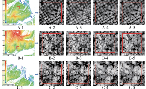
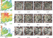
Fig. 4
Tree crown segmentation results of different segmentation methods In the figure, 1, 2, 3, 4 and 5 represent the original point cloud data and plot location (colored by elevation), the CHM image after filtering, the segmentation results of the mean shift method, the watershed segmentation method, and the segmentation results of the method used in this study. denotes the plot boundaries, and indicates the position of individual trees."
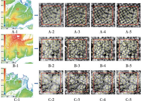
Table 2
Comparison of segmentation accuracy of different methods"
| 冠层类型 canopy layer type | 样地序号 sample No. | 实测株树 quantity of tree | 总体精度(OA) overall accuracy | 误判误差 (CE) commission error | 漏判误差(OE) omission error | |||||||
|---|---|---|---|---|---|---|---|---|---|---|---|---|
| 本研究 this paper | 分水岭 watershed | 均值漂移 mean shift | 本研究 this paper | 分水岭 watershed | 均值漂移 mean shift | 本研究 this paper | 分水岭 watershed | 均值漂移 mean shift | ||||
| A阔叶混交林 broad-leaved mixed forest | 1 | 41 | 0.71 | 0.37 | 0.37 | 0.27 | 0.61 | 0.61 | 0.02 | 0.02 | 0.02 | |
| 2 | 52 | 0.79 | 0.42 | 0.37 | 0.21 | 0.54 | 0.58 | 0.00 | 0.04 | 0.05 | ||
| 3 | 41 | 0.76 | 0.44 | 0.32 | 0.22 | 0.56 | 0.66 | 0.02 | 0.00 | 0.02 | ||
| 均值mean | 45 | 0.75 | 0.41 | 0.35 | 0.23 | 0.57 | 0.62 | 0.02 | 0.02 | 0.03 | ||
| B针叶混交林 coniferous mixed forest | 4 | 67 | 0.97 | 0.78 | 0.66 | 0.03 | 0.21 | 0.31 | 0.00 | 0.01 | 0.03 | |
| 5 | 62 | 0.94 | 0.81 | 0.74 | 0.05 | 0.18 | 0.23 | 0.02 | 0.02 | 0.03 | ||
| 6 | 56 | 0.98 | 0.84 | 0.71 | 0.02 | 0.16 | 0.24 | 0.00 | 0.00 | 0.05 | ||
| 均值mean | 62 | 0.96 | 0.81 | 0.70 | 0.03 | 0.18 | 0.26 | 0.01 | 0.01 | 0.04 | ||
| C针阔混交林 coniferous broad- leaved mixed forest | 7 | 59 | 0.86 | 0.69 | 0.54 | 0.10 | 0.29 | 0.41 | 0.03 | 0.02 | 0.05 | |
| 8 | 65 | 0.82 | 0.72 | 0.58 | 0.14 | 0.25 | 0.38 | 0.05 | 0.03 | 0.04 | ||
| 9 | 57 | 0.84 | 0.68 | 0.56 | 0.11 | 0.30 | 0.40 | 0.05 | 0.02 | 0.04 | ||
| 均值mean | 60 | 0.84 | 0.70 | 0.57 | 0.12 | 0.28 | 0.40 | 0.04 | 0.02 | 0.03 | ||
| 总体均值total mean | 56 | 0.85 | 0.64 | 0.55 | 0.13 | 0.34 | 0.43 | 0.02 | 0.02 | 0.02 | ||
Fig. 5
Crown extraction accuracy based on the method in this paper"
| [1] | 解宇阳, 王彬, 姚扬, 等. 基于无人机激光雷达遥感的亚热带常绿阔叶林群落垂直结构分析[J]. 生态学报, 2020, 40(3):196-207. |
| XIE Y Y, WANG B, YAO Y, et al. Quantification of vertical community structure of subtropical evergreen broadleaved forest community using UAV-Lidar data[J]. Acta Ecologica Sinica, 2020, 40(3):196-207. DOI:10.5846/stxb201809282112. | |
| [2] | 陈宗铸, 杨琦, 雷金睿, 等. 基于激光雷达数据的热带森林冠高模型生成及平均树高估计[J]. 中南林业科技大学学报, 2018, 38(7):1-7. |
| CHEN Z T, YANG Q, LEI J R, et al. Generation of tropical forest canopy height model and estimation of average tree height based on lidar data[J]. Journal of Central South University of Forestry and Technology, 2018, 38(7):1-7. DOI:10.14067/j.cnki.1673-923x.2018.07.001. | |
| [3] | 巨一琳, 姬永杰, 黄继茂, 等. 联合LiDAR和多光谱数据森林地上生物量反演研究[J]. 南京林业大学学报(自然科学版), 2022, 46(1):58-68. |
| JU Y L, JI Y J, HUANG J M, et al. Inversion of forest aboveground biomass using combination of LiDAR and multispectral data[J]. Journal of Nanjing Forestry University(Natural Sciences Edition), 2022, 46(1):58-68. Doi: 10.12302/j.issn.1000-2006.202109029. | |
| [4] | ALVITES C I, SANTOPUOLI G, MAESANO M, et al. Unsupervised algorithms to detect single trees in a mixed-species and multi-layered Mediterranean forest using LiDAR data[J]. Canadian Journal of Forest Research, 2021, 51(12):1766-1780. DOI:10.1139/cjfr-2020-0510. |
| [5] | JIANG X, LI G, LU D, et al. Modelingforest aboveground carbon density in the brazilian amazon with integration of MODIS and airborne LiDAR data[J]. Remote Sensing, 2020, 12(20): 3330. DOI:10.3390/rs12203330. |
| [6] | 张冬, 云挺, 薛联凤, 等. 基于力场的点云树木骨架提取方法[J]. 南京林业大学学报(自然科学版), 2016, 40(2):160-166. |
| ZHANG D, YUN T, XUE L F, et al. Skeleton extraction for point cloud trees based on force field[J]. Journal of Nanjing Forestry University(Natural Sciences Edition), 2016, 40(2):160-166. DOI:10.3969/j.issn.1000-2006.2016.02.027. | |
| [7] | BLACKBURN R C, BUSCAGLIA R, MEADOR A. Mixtures of airborne lidar-based approaches improve predictions of forest structure[J]. Canadian Journal of Forest Research, 2021, 51(8):1106-1116. DOI:10.1139/cjfr-2020-0506 |
| [8] | 李文娟, 赵传燕, 别强, 等. 基于机载激光雷达数据的森林结构参数反演[J]. 遥感技术与应用, 2015, 30(5):917-924. |
| LI W J, ZHAO C Y, BIE Q, et al. Retrieval of the forest structural parameters using airborne LiDAR data[J]. Remote Sensing Technology and Application, 2015, 30(5):917-924. DOI:10.11873/j.issn.1004-0323.2015.5.0917. | |
| [9] | VALERO S, KNAPP D E, TOCHON G, et al. On the use of binary partition trees for the tree crown segmentation of tropical rainforest hyperspectral images[J]. Remote Sensing of Environment, 2015, 159:318-331.DOI:10.1016/j.rse.2014.12.020. |
| [10] | 王辉, 韩娜娜, 吕程序, 等. 基于Mask R-CNN的单株柑橘树冠识别与分割[J]. 农业机械学报, 2021, 52(5):169-174. |
| WANG H, HAN N N, LYU C X, et al. Recognition and segmentation of individual citrus tree crown based on Mask R-CNN[J]. Transactions of the Chinese Society of Agricultural Machinery, 2021, 52(5):169-174. DOI:10.6041/j.issn.1000-1298.2021.05.018. | |
| [11] | 程晓菲, 武刚. 基于高分辨率卫星影像的CV模型单木定位法[J]. 南京林业大学学报(自然科学版), 2022, 46(5):143-151. |
| CHEN X F, WU G. Locating individual tree from high resolution satellite images based on CV model[J]. Journal of Nanjing Forestry University(Natural Sciences Edition), 2022, 46(5):143-151. DOI:10.12302/j.issn.1000-2006.202102020. | |
| [12] | 孙振峰, 张晓丽, 李霓雯. 机载与星载高分遥感影像单木树冠分割方法和适宜性对比[J]. 北京林业大学学报, 2019, 41(11):66-75. |
| SUN Z F, ZHANG X L, LI N W. Comparison of individual tree crown extraction method and suitability of airborne and spaceborne high-resolution remote sensing images[J]. Journal of Beijing Forestry University, 2019, 41(11):66-75. DOI:10.13332/j.1000-1522.20180446. | |
| [13] | YANG L, SHENG Y H, WANG B. 3D reconstruction of building facade with fused data of terrestrial LiDAR data and optical image[J]. Optik, 2016, 127(4):2165-2168. DOI:10.1016/j.ijleo.2015.11.147. |
| [14] | MAN Q, DONG P, GUO H. Pixel and feature-level fusion of hyperspectral and lidar data for urban land-use classification[J]. International Journal of Remote Sensing, 2015, 36(5/6):1618-1644. DOI:10.1080/01431161.2015.1015657. |
| [15] | LI Y, JAVIER I G. LiDAR for autonomous driving: the principles, challenges, and trends for automotive lidar and perception systems[J]. IEEE Signal Processing Magazine, 2020, 37(4):50-61. DOI:10.1109/MSP.2020.2973615. |
| [16] | FABAIN D, REIK L, FELIX M, et al. Simulating imaging spectrometer data: 3D forest modeling based on LiDAR and in situ data[J]. Remote Sensing of Environment, 2014, 152:235-250. DOI: 10.1016/j.rse.2014.06.015. |
| [17] | 徐志扬, 刘浩栋, 陈永富, 等. 基于无人机LiDAR的杉木树冠上部外轮廓模拟与可视化研究[J]. 林业科学研究, 2021, 34(4):9. |
| XU Z Y, LIU H D, CHEN Y F, et al. Outer upper crown profile aimulation and visualization for Cunninghamia lanceolata based on UAV-borne LiDAR data[J]. Forest Research, 2021, 34(4):9. DOI:10.13275/j.cnki.lykxyj.2021.04.005. | |
| [18] | HUO L, LINDBERG E, HOLMGREN J. Towards low vegetation identification:a new method for tree crown segmentation from LiDAR data based on a symmetrical structure detection algorithm (SSD)[J]. Remote Sensing of Environment, 2022, 270: 112857. DOI:10.1016/j.rse.2021.112857. |
| [19] | AYREY E, FARVER S, KERSHAW, et al. Layer Stacking: a novel algorithm for individual forest tree segmentation from LiDAR point clouds[J]. Canadian Journal of Remote Sensing, 2017, 43(1):16-27. DOI:10.1080/07038992.2017.1252907. |
| [20] | HUI Z, LI N, XIA Y, et al. Individual tree extraction from UAV LIDAR point clouds based on self-adaptive mean shift segmentation[J]. ISPRS Annals of the Photogrammetry, Remote Sensing and Spatial Information Sciences, 2021(1):25-30. DOI:10.5194/isprs-annals-V-1-2021-25-2021. |
| [21] | CHEN X, JIANG K, ZHU Y, et al. Individual tree crown segmentation directly from UAV-borne LiDAR data using thePointNet of deep learning[J]. Forests, 2021, 12(2):131. DOI:10.3390/f12020131. |
| [22] | WANG J, CHEN X, CAO L, et al. Individual rubber tree segmentation based on ground-based LiDAR data and faster R-CNN of deep learning[J]. Forests, 2019, 10(9):793-813. DOI:10.3390/f10090793. |
| [23] | 黄昕晰, 夏凯, 冯海林, 等. 基于无人机影像与Mask R-CNN的单木树冠检测与分割[J]. 林业工程学报, 2021, 6(2):133-140. |
| HUANG X X, XIA K, FENG H L, et al. Research on individual tree crown detection and segmentation using UAV imaging and Mask R-CNN[J]. J Fore Eng, 2021, 6(2):133-140.DOI:10.13360/j.issn.2096-1359.202009004. | |
| [24] | VINCENT L, SOILLE P. Watersheds in digital spaces: an efficient algorithm based on immersion simulations[J]. IEEE Computer Society, 1991, 13(6):583-598. DOI:10.1109/34.87344. |
| [25] | CHEN Q, DENNIS B, GONG P, et al. Isolating individual trees in a savanna woodland using small footprint LIDAR data[J]. Photogrammetric Engineering and Remote Sensing, 2006, 72(8):923-932. DOI:10.14358/PERS.72.8.923. |
| [26] | 王鑫运, 黄杨, 邢艳秋, 等. 基于无人机高密度LiDAR点云的人工针叶林单木分割算法[J]. 中南林业科技大学学报, 2022, 42(8):66-77. |
| WANG X Y, HUANG Y, LI D J, et al. The single tree segmentation of UAV high-density LiDAR point cloud data based on coniferous plantations[J]. Journal of Central South University of Forestry and Technology, 2022, 42(8):66-77. DOI:10.14067/j.cnki.1673-923x.2022.08.007. | |
| [27] | 李岩, 史泽林, 程坤, 等. 运用激光雷达数据的单木树冠提取算法对帽儿山林场单木参数估测的影响[J]. 东北林业大学学报, 2019, 47(11):61-67. |
| LI Y, SHI Z L, CHEN K, et al. Effect of three individual tree crown delineation algorithms on estimating individual tree parameters with LiDAR data[J]. Journal of Northeast Forestry University, 2019, 47(11):61-67. DOI:10.13759/j.cnki.dlxb.2019.11.012. | |
| [28] |
张海清, 李向新, 王成, 等. 结合DSM的机载LiDAR单木树高提取研究[J]. 地球信息科学学报, 2021, 23(10):1873-1881.
doi: 10.12082/dqxxkx.2021.210030 |
| ZHANG H Q, LI X X, WANG C, et al. Individual tree height extraction from airborne LiDAR data by combining with DSM[J]. Journal of Geo-information Science, 2021, 23(10):1873-1881. DOI:10.12082/dqxxkx.2021.210030. | |
| [29] |
LOPES A, NEZRY E, TOUZI R, et al. Structure detection and statistical adaptive speckle filtering in SAR images[J]. International Journal of Remote Sensing, 1993, 14(9):1735-1758.
doi: 10.1080/01431169308953999 |
| [30] | 贾惠珍, 王同罕. 基于自适应微调因子的改进 frost 滤波[J]. 计算机工程与设计, 2011, 32(11): 3793-3795. |
| JIA H Z, WANG T H. Modified frost filtering based on adaptive parameter[J]. Computer Engineering and Design, 2011, 32(11):3793-3795. | |
| [31] |
VINCENT L. Morphological grayscale reconstruction in image analysis: applications and efficient algorithms[J]. IEEE transactions on image processing, 1993, 2(2):176-201. DOI:10.1109/83.217222.
pmid: 18296207 |
| [32] | 李增元, 庞勇, 刘清旺, 等. 激光雷达森林参数反演技术与方法[M]. 北京: 科学出版社, 2015. |
| LI Z Y, PANG Y, LIU Q W, et al. Lidar forest parameter inversion technology and method[M]. Beijing: Science Press, 2015. | |
| [33] | 王娟, 张超, 陈巧, 等. 结合无人机可见光和激光雷达数据的杉木树冠信息提取[J]. 西南林业大学学报, 2022, 42(1):133-141. |
| WANG J, ZHANG C, CHEN Q, et al. The method of extracting information of Cunninghamia lanceolata crown combined with RGB and LiDAR based on UAV[J]. Journal of Southwest Forestry University. 2022, 42(1):133-141. DOI: 10.11929/j.swfu.202101013. | |
| [34] | 汪垚, 张志玉, 倪文俭, 等. 基于机载LiDAR数据的林下地形提取算法比较与组合分析[J]. 北京林业大学学报, 2017, 39(12):25-35. |
| WANG Y, ZHANG Z Y, NI W J, et al. Comparison of filter algorithms and combination analysis for DEM extracting based on airborne laser scanning point clouds[J]. Journal of Beijing Forestry University, 2017, 39(12):25-35. DOI: 10.13332/j.1000-1522.20170300. |
| [1] | XIN Shidong, JIANG Lichun, MU Lin. Predictive model of stand tree layer additive carbon storage of Korean pine plantation in Heilongjiang Province, China [J]. JOURNAL OF NANJING FORESTRY UNIVERSITY, 2022, 46(1): 115-121. |
| [2] | CUI Zeyu, ZHANG Huaiqing, ZUO Yuanqing, YANG Tingdong, LIU Yang, ZHANG Jing, WANG Linlong. The distribution of under branch heights in various directions of the three-dimensional Chinese fir model [J]. JOURNAL OF NANJING FORESTRY UNIVERSITY, 2022, 46(1): 81-87. |
| [3] | SHAN Kaili, ZANG Hao, PAN Ping, NING Jinkui, OUYANG Xunzhi. Individual tree crown width prediction models for natural Phoebe bournei in central Jiangxi Province [J]. JOURNAL OF NANJING FORESTRY UNIVERSITY, 2022, 46(1): 88-96. |
| [4] | WANG Dongzhi, HU Xuejiao, LI Dayong, GAO Yushan, LI Tianyu. Creating site indexes for needle and broadleaved mixed forest using the nonlinear mixed effect model [J]. JOURNAL OF NANJING FORESTRY UNIVERSITY, 2020, 44(4): 159-166. |
| [5] | PAN Lei, SUN Yujun, WANG Yifu, CHEN Liping, CAO Yuanshuai. Estimation of aboveground biomass in a Chinese fir (Cunninghamia lanceolata)forest combining data of Sentinel⁃1 and Sentinel⁃2 [J]. JOURNAL OF NANJING FORESTRY UNIVERSITY, 2020, 44(3): 149-156. |
| [6] | ZHOU Zeyu, YANG Raohua, ZHANG Yuzhen, HUANG Xuanrui, ZHANG Zhidong, WANG Dongzhi, LI Dayong. Prediction model construction of diameter distribution of Larix principis-rupprechtii plantation [J]. JOURNAL OF NANJING FORESTRY UNIVERSITY, 2020, 44(2): 117-124. |
| [7] | LI Guangyou, XU Jianmin, WANG Wei, WU Shijun, ZHU Ying'an, WANG Yingsheng, PAN Jian, GUO Hongying, SHI Tingyou. Study on heterosis estimation and genetic analysis of Eucalyptus hybrids in cold area [J]. JOURNAL OF NANJING FORESTRY UNIVERSITY, 2017, 41(04): 55-63. |
| [8] | ZHANG Mifang,HU Man,LI Mingyang. Estimation of stock volume of urban forest using fully polarimetric radar data of PALSAR [J]. JOURNAL OF NANJING FORESTRY UNIVERSITY, 2016, 40(06): 56-62. |
| [9] | YANG Ming,WANG Yueting,ZHANG Xiaoli. Study on the model for estimating forest volume of Chinese fir based on bi-source remote sensing data [J]. JOURNAL OF NANJING FORESTRY UNIVERSITY, 2016, 40(05): 107-114. |
| Viewed | ||||||
|
Full text |
|
|||||
|
Abstract |
|
|||||