
JOURNAL OF NANJING FORESTRY UNIVERSITY ›› 2025, Vol. 49 ›› Issue (2): 175-184.doi: 10.12302/j.issn.1000-2006.202309009
Previous Articles Next Articles
KONG Delun( ), XING Yanqiu*()
Received:2023-09-07
Accepted:2024-01-08
Online:2025-03-30
Published:2025-03-28
Contact:
XING Yanqiu
E-mail:1394661761@qq.com;yanqiuxing@nefu.edu.cn
CLC Number:
KONG Delun, XING Yanqiu. Inversion of tree height from GEDI and ICESat-2 spaceborne lidar[J]. JOURNAL OF NANJING FORESTRY UNIVERSITY, 2025, 49(2): 175-184.
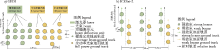
Fig. 1
Beam sampling modes of GEDI and ICESat-2"
Fig. 2
Terrain height difference of GEDI and ICESat-2 The numbers in the figure represent the number of spot points scanned corresponding to the horizontal axis. n represents the total number of light spots scanned in the area under this condition."
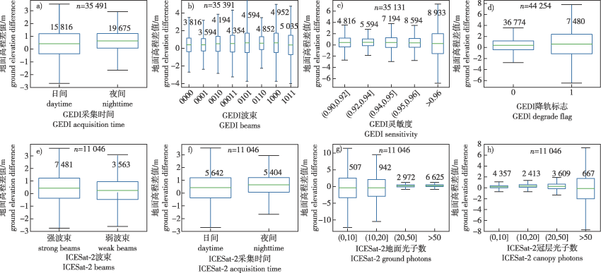
Table 1
GEDI L2A classification with different algorithm group"
| 算法组 algorithm group | 噪声阈值 noise threshold | 信号阈值 signal threshold | 起始阈值 front threshold | 结束阈值 back threshold |
|---|---|---|---|---|
| a1 | 6.5σ | 6.5σ | 3σ | 6σ |
| a2 | 6.5σ | 3.5σ | 3σ | 3σ |
| a3 | 6.5σ | 3.5σ | 3σ | 6σ |
| a4 | 6.5σ | 6.5σ | 6σ | 6σ |
| a5 | 6.5σ | 3.5σ | 3σ | 2σ |
| a6 | 6.5σ | 3.5σ | 3σ | 4σ |
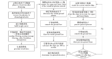
Fig. 3
The flow chart based on slope classification algorithm"
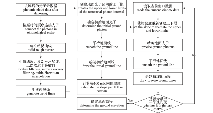
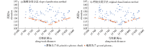
Fig. 4
Differences in different parameters of photon cloud ground line"
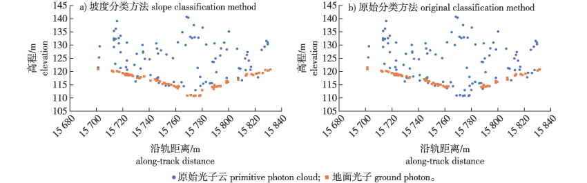
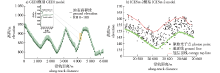
Fig. 5
Tree height models of GEDI and ICESat-2"
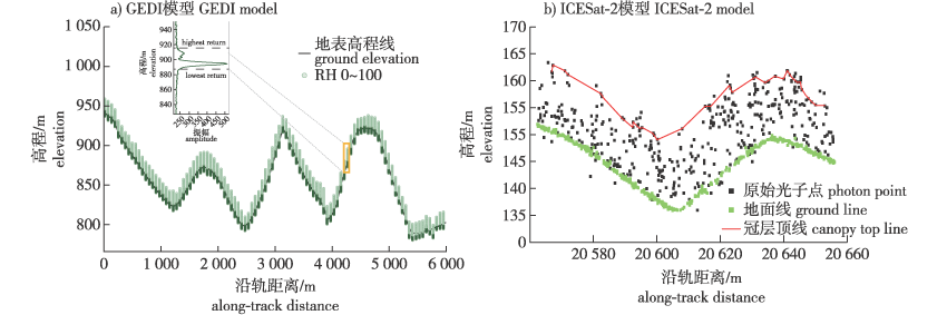
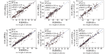
Fig. 6
GEDI algorithm set and airborne data inversion tree height scatter plot"
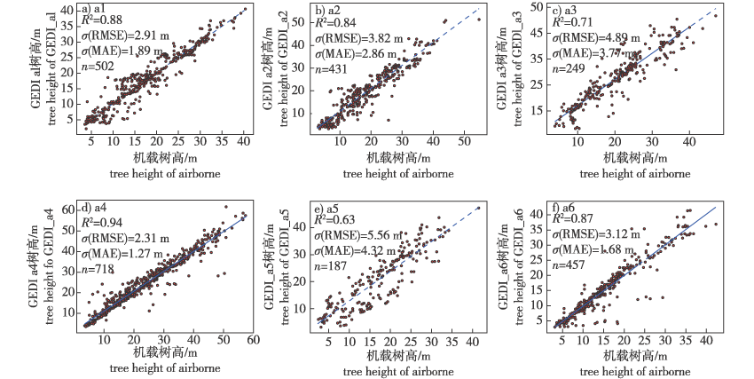

Fig. 7
NASA algorithm and the algorithm in this paper invert tree height contrast scatter plot"

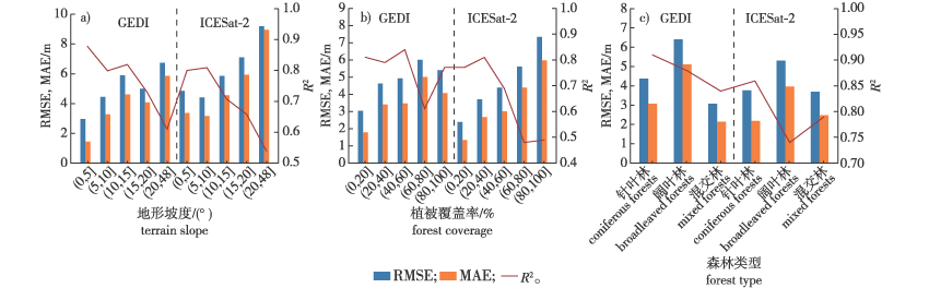
Fig. 8
Quantitative accuracy evaluation of inversion tree height of spaceborne lidar under different factors"
| [1] | HAYASHI M, SAIGUSA N, OGUMA H, et al. Measuring forest canopy height using ICESat/GLAS data for applying to Japanese spaceborne lidar mission[C]// Lidar Remote Sensing for Environmental Monitoring XIII.Kyoto,Japan.SPICE, 2012,8526:85260.DOI:10.1117/12.981583. |
| [2] | URBAZAEV M, HESS L L, HANCOCK S, et al. Assessment of terrain elevation estimates from ICESat-2 and GEDI spaceborne LiDAR missions across different land cover and forest types[J]. Sci Remote Sens, 2022,6:100067. DOI:10.1016/j.srs.2022.100067. |
| [3] | MA L, HURTT G, TANG H, et al. Spatial heterogeneity of global forest aboveground carbon stocks and fluxes constrained by spaceborne lidar data and mechanistic modeling[J]. Glob Chang Biol, 2023, 29(12):3378-3394.DOI:10.1111/gcb.16682. |
| [4] | SUN T, QI J B, HUANG H G. Discovering forest height changes based on spaceborne lidar data of ICESat-1 in 2005 and ICESat-2 in 2019:a case study in the Beijing-Tianjin-Hebei region of China[J]. For Ecosyst, 2020, 7(1):53. DOI:10.1186/s40663-020-00265-w. |
| [5] | LIN X D, SHANG R, CHEN J M, et al. High-resolution forest age mapping based on forest height maps derived from GEDI and ICESat-2 space-borne lidar data[J]. Agric For Meteor, 2023,339:109592. DOI:10.1016/j.agrformet.2023.109592. |
| [6] | ZHU W D, YANG F, QIU Z G, et al. Enhancing forest canopy height retrieval: insights from integrated GEDI and Landsat data Analysis[J]. Sustainability, 2023, 15(13):10434.DOI:10.3390/su151310434. |
| [7] | 胡艳, 王迪, 刘凌菲, 等. 利用大光斑激光雷达估测小兴安岭平均树高[J]. 安徽农业科学, 2014, 42(15):4707-4709. |
| HU Y, WANG D, LIU L F, et al. Estimation of forest tree average heights from GLAS data in lesser Khingan mountains[J]. J Anhui Agric Sci, 2014, 42(15):4707-4709.DOI:10.13989/j.cnki.0517-6611.2014.15.094. | |
| [8] | 董瀚元, 于颖, 范文义. 星载激光雷达GEDI数据林下地形反演性能验证[J]. 南京林业大学学报(自然科学版), 2023, 47(2):141-149. |
| DONG H Y, YU Y, FAN W Y. Verification of performance of understory terrain inversion from spaceborne lidar GEDI data[J]. J Nanjing For Univ (Nat Sci Ed), 2023, 47(2):141-149. | |
| [9] | 吴伟东. 联合卫星遥感影像与光子雷达数提取山林地区数字高程模型[D]. 广州: 广东工业大学, 2022. |
| [13] | GUPTA R, SHARMA L K. Mixed tropical forests canopy height mapping from spaceborne LiDAR GEDI and multisensor imagery using machine learning models[J]. Remote Sens Appl Soc Environ, 2022, 27(2):100817.DOI:10.1016/j.rsase.2022.100817. |
| [14] | DUBAYAH R, BLAIR J B, GOETZ S, et al. The global ecosystem dynamics investigation:high-resolution laser ranging of the earth’s forests and topography[J]. Sci Remote Sens, 2020,1:100002.DOI:10.1016/j.srs.2020.100002. |
| [15] | MARKUS T, NEUMANN T, MARTINO A, et al. The ice,cloud, and land elevation satellite-2 (ICESat-2):science requirements,concept,and implementation[J]. Remote Sens Environ, 2017, 190:260-273.DOI:10.1016/j.rse.2016.12.029. |
| [16] | 陆大进, 黎东, 朱笑笑, 等. 基于卷积神经网络的ICESat-2光子点云去噪分类[J]. 地球信息科学学报, 2021, 23(11):2086-2095. |
| LU D J, LI D, ZHU X X, et al. Denoising and classification of ICESat-2 photon point cloud based on convolutional neural network[J]. J Geo Inf Sci, 2021, 23(11):2086-2095. | |
| [17] | NEUENSCHWANDER A, PITTS K. The ATL08 land and vegetation product for the ICESat-2 Mission[J]. Remote Sens Environ, 2019, 221:247-259.DOI:10.1016/j.rse.2018.11.005. |
| [18] | ZOU S, PAN H, ZOU Z, et al. ICESat-2 laser altimetry data-guided high-accuracy positioning of satellite stereo images[J]. ISPRS Ann Photogramm Remote Sens Spatial Inf Sci, 2022, 41(1):41-48.DOI:10.5194/isprs-annals-V-1-2022-41-2022. |
| [19] | 陈雨莹, 王龑, 邹艳红, 等. 全球土地覆盖产品中森林类型数据在中国区域的质量评估[J]. 遥感技术与应用, 2023, 38(2):341-352. |
| CHEN Y Y, WANG Y, ZOU Y H, et al. Assessment of forest type data in global land cover products over China[J]. Remote Sens Technol Appl, 2023, 38(2):341-352.DOI: 10.11873/j.issn.1004-0323.2023.2.0341. | |
| [20] | ZHU X X, NIE S, WANG C, et al. Consistency analysis of forest height retrievals between GEDI and ICESat-2[J]. Remote Sens Environ, 2022,281:113244.DOI:10.1016/j.rse.2022.113244. |
| [21] | 韩明辉, 邢艳秋, 李国元, 等. GEDI不同算法组数据反演森林最大冠层高度和生物量精度比较[J]. 中南林业科技大学学报, 2022, 42(10):72-82. |
| [9] | WU W D. Extraction of digital elevation model in mountain forest area by combining satellite remote sensing image and photon radar number[D]. Guangzhou: Guangdong University of Technology, 2022. |
| [10] | 黄佳鹏. 基于ICESat-2/ATLAS光子计数LiDAR数据反演森林冠层高度研究[D]. 哈尔滨: 东北林业大学, 2021. |
| HUANG J P. Inversion of forest canopy height based on ICESat-2/ATLAS photon counting LiDAR data[D].Harbin: Northeast Forestry University, 2021.DOI: 10.27009/d.cnki.gdblu.2021.000073. | |
| [11] | 覃志刚, 尤号田, 黄元威, 等. 不同植被覆盖区ICESat-2和GF-7卫星地表高程信息对比研究[J]. 航天返回与遥感, 2023, 44(5):91-104. |
| QIN Z G, YOU H T, HUANG Y W, et al. Research on comparsion of surface elevation information of different vegetation cover types based on ICESat-2 and GF-7 satellite data[J]. Spacecr Recovery Remote Sens, 2023, 44(5):91-104.DOI: 10.3969/j.issn.1009-8518.2023.05.011. | |
| [12] | 张少伟. 基于多源数据的内蒙古大兴安岭林区森林资源变化监测研究[D]. 北京: 中国林业科学研究院, 2019. |
| ZHANG S W. Monitoring of forest resources change in Daxinganling forest region of Inner Mongolia based on multi-source data[D]. Beijing: Chinese Academy of Forestry, 2019. | |
| [21] | HAN M H, XING Y Q, LI G Y, et al. Comparison of the accuracy of the maximum canopy height and biomass inversion of the data of different GEDI algorithm groups[J]. J Cent South Univ For Technol, 2022, 42(10):72-82. DOI: 10.14067/j.cnki.1673-923x.2022.10.009. |
| [22] | 秦磊. 基于ICESat-2星载激光雷达光子云数据反演森林冠层高度方法研究[D]. 哈尔滨: 东北林业大学, 2020. |
| QIN L. Study on the method of retrieving forest canopy height based on the photon cloud data of ICESat-2 spaceborne lidar[D].Harbin: Northeast Forestry University, 2020. | |
| [23] | 王丽, 李毅, 朱建军, 等. ICESat-2 ATL08地形和冠层高度产品精度评估[J]. 遥感信息, 2023, 38(4): 144-152. |
| WANG L, LI Y, ZHU J J, et al. Accuracy assessment of ICESat-2 ATL08 terrain and canopy heights[J]. Remote Sens Info, 2023, 38(4): 144-152.DOI:10.20091/j.cnki.1000-3177.2023.04.018. |
| [1] | JIANG Mingyue, HUANG Qingyang, YANG Fan, XIE Lihong, CAO Hongjie, SHA Gang. Response of soil humification degree in Wudalianchi kipuka to the decomposition of foliar litter in the home-field advantage [J]. JOURNAL OF NANJING FORESTRY UNIVERSITY, 2025, 49(3): 190-196. |
| [2] | DONG Hanyuan, YU Ying, FAN Wenyi. Verification of performance of understory terrain inversion from spaceborne lidar GEDI data [J]. JOURNAL OF NANJING FORESTRY UNIVERSITY, 2023, 47(2): 141-149. |
| [3] | QIU Fengting, GUO Zhifeng, ZHANG Zongke, WEI Xianhu, LI Junjie, LYU Zheng. Spatio-temporal change characteristics of vegetation coverage and its relationship with meteorological factors in the Greater Mekong Subregion [J]. JOURNAL OF NANJING FORESTRY UNIVERSITY, 2022, 46(2): 187-195. |
| [4] | HUANG Jian, WU Dasheng, FANG Luming. Identification of sub-compartment forest type based on multi-source data and three-tier models [J]. JOURNAL OF NANJING FORESTRY UNIVERSITY, 2022, 46(1): 69-80. |
| [5] | ZHU Jiaqi, MAN Xiuling, WANG Fei. Organic carbon and nitrogen characteristics of soil aggregates in four forest types in frigid temperate zone [J]. JOURNAL OF NANJING FORESTRY UNIVERSITY, 2021, 45(5): 71-83. |
| [6] | CAI Longtao, XING Tao, XING Yanqiu, DING Jianhua, HUANG Jiapeng, CUI Yang, QIN Lei. Identification of forest types based on ICESat-GLAS data and fuzzy pattern recognition algorithm [J]. JOURNAL OF NANJING FORESTRY UNIVERSITY, 2021, 45(4): 33-40. |
| [7] | WANG Bing, ZHANG Pengjie, ZHANG Qiuliang. Characteristics of the soil aggregate and its organic carbon in different Larix gmelinii forest types [J]. JOURNAL OF NANJING FORESTRY UNIVERSITY, 2021, 45(3): 15-24. |
| [8] | HU Hong, XU Yanli, JU Hongbo, SUN Zhichao. Monitoring and analysis of county-level vegetation cover change in Changting, Fujian based on remote sensing images [J]. JOURNAL OF NANJING FORESTRY UNIVERSITY, 2019, 43(03): 92-98. |
| [9] | WU Guoxun, TANG Xuejun, RUAN Honghua, LUO Xifang. Carbon storage and carbon sequestration potential based on forest inventory data in Jiangxi Province, China [J]. JOURNAL OF NANJING FORESTRY UNIVERSITY, 2019, 43(01): 105-110. |
| [10] | CHEN Lixin, LIANG Weiwei, DUAN Wenbiao, LI Gang, LI Yifei, LI Shaoran, MA Haijuan. Effects of low molecular weight organic acid on inorganic phosphorus fractions of typical temperate forest soils [J]. JOURNAL OF NANJING FORESTRY UNIVERSITY, 2018, 42(04): 75-82. |
| [11] | ZHU Guangyu, HU Song, FU Liyong. Basal area growth model for oak natural forest in Hunan Province based on dummy variable [J]. JOURNAL OF NANJING FORESTRY UNIVERSITY, 2018, 42(02): 155-162. |
| [12] | WANG Xing, CUI Xiaoyang, GUO Yafen. A study on free amino acid in different forest types soil of cold-temperate forest region [J]. JOURNAL OF NANJING FORESTRY UNIVERSITY, 2016, 40(04): 42-48. |
| [13] | WU Chuping, YE Jihua, HUANG Yujie, ZHU Jinru, SHEN Aihua, YUAN Weigao, JIANG Bo. Effects of different forest types on water quality in Zhoushan Island, Zhejiang Province [J]. JOURNAL OF NANJING FORESTRY UNIVERSITY, 2015, 39(04): 75-80. |
| [14] | YANG Yanrong, ZHANG Zengxin, ZHANG Jinchi, LIU Chunming, ZHUANG Jiayao. A study on the relationship between vegetation coverage and regional climate change in middle and lower reaches of Yangtze River [J]. JOURNAL OF NANJING FORESTRY UNIVERSITY, 2013, 37(06): 89-95. |
| [15] | WEI Qiang,ZHANG Guangzhong,LING Lei,CHAI Chunshan. Water conservation function of litter and soil layer under main forest types in Xinglong Mountain of Gansu [J]. JOURNAL OF NANJING FORESTRY UNIVERSITY, 2013, 37(02): 78-84. |
| Viewed | ||||||
|
Full text |
|
|||||
|
Abstract |
|
|||||